Download presentation
Presentation is loading. Please wait.

1
History & Demographic Structure of Phila. Mapping Angles

2
Sections: Philadelphia Population: Statewide Historical Context Choropleth maps Philadelphia, Pittsburgh, and nearby Time trend Philly itself: Spatial History Map choices Law Behaving 1920s Delinquency Data

3
United States Census U.S. Constitution Requires census of population Every ten years Used for redistricting House of Representatives 1790-2000 Methods changed over years Can use Census Figures for Historical Trends http://www.census.gov/main/www/aboutus.html Census HQ in Maryland

4
Pennsylvania Counties Pennsylvania Counties Pittsburgh is within Allegheny County

5
History of Pennsylvania Population by County Using Maps Legend How many groups? What are ranges within each group? Map type: choropleth map “shows numerical data … for a group of regions by (1) grouping the data into classes, and (2) shading each class on the map.” Prentice Hall. “Making maps with GIS.” http://wps.prenhall.com/esm_clarke_gsgis_4/0,7300, 473320-,00.html
 grouping the data into classes, and (2) shading each class on the map. Prentice Hall. Making maps with GIS ,00.html.")
6
1790 Population By County

7
1850 Population By County Note legend change

8
1900 Population By County Note legend change again

9
1950 Population By County

10
2000 Population By County

11
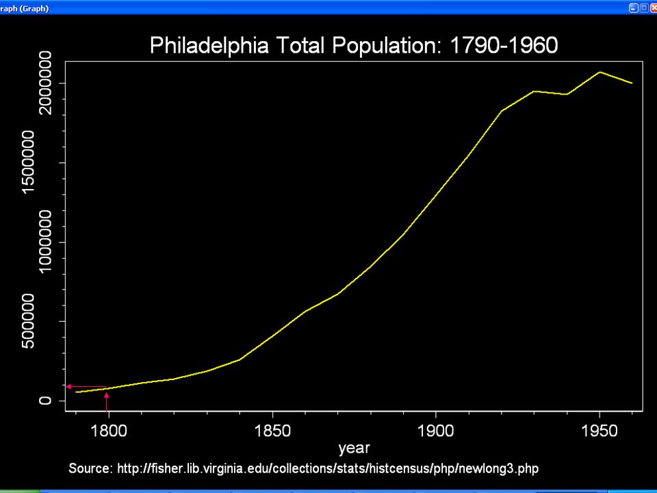
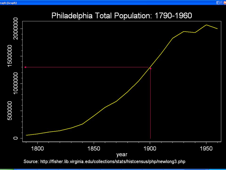
Philadelphia: more detail over time Line charts X Axis (horizontal): organizing variable (time) Y axis (vertical): variable being measured (population)
: organizing variable (time) Y axis (vertical): variable being measured (population)")
16
Steady growth, 1840-1930

17
Peak population

18
Sources of growth?

19
Immigration Foreign Domestic Growth of Jobs Manufacturing Commerce (ship, railroad) Incorporation Surrounding towns incorporated (1854)
 Incorporation Surrounding towns incorporated (1854)")
20
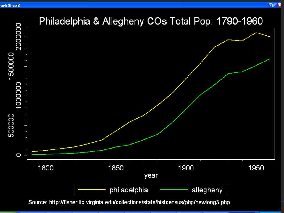
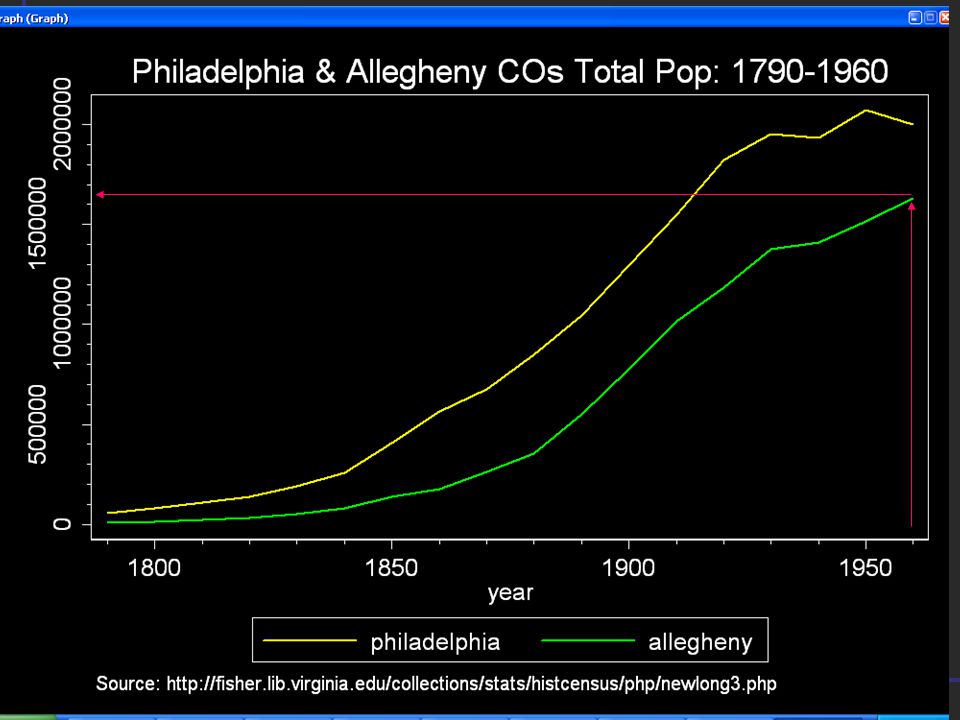
Compared to Pittsburgh (Allegheny Co.)?
")
22
When did Pittsburgh’s Steady Growth Begin?

23
1880

24
Did Pittsburgh every reach 2 million?

26
From 1880 to 1930, where Philly and Pittsburgh adding about the same number of people every year?

27
Since the Two lines Are PARALLEL Over time, We will say yes

28
What was happening in Philadelphia’s two adjoining counties to the west? Delaware Montgomery?

31
As late as 1930, The population in each Was only about _____

32
Sections: Philadelphia Population: Statewide Historical Context Choropleth maps Philadelphia, Pittsburgh, and nearby Time trend Philly itself: History Map and demographic data within Philly Choices Modifiable areal unit problem

33
Philadelphia 1681 Small port city on Delaware River

34
The Old Commercial Center? Hard to pinpoint Approximate: Customs house would be nearby Foreign vessels

35
Carpenters Hall, Custom’s House 1801-1817 Between. 3 rd, 4 th below Chestnut St.

36
x Lower Dock Area X = Carpenter Hall Circle= Society Hill, Olde City

37
Over time, the harbor spread Both to the north and south

38
As it spread, warehouses And canneries And cheap housing for Immigrants working in harbor Or related industries grew up Over time became substandard, Increasingly crowded. Often, only housing affordable for Bottom rung workers

39
Over time, housing Expands outward, Back from harbor; Along major routes, Horse drawn trolley, Then trolley Newer housing more $ As housing ages, it Gets cheaper

40
Same time, Downtown expanding Businesses taking Over Poor Residential districts Downtown Expands to Meet Increasing Population to be Served In the city and beyond

41
because …. Different types of people live in different places Ebenezer Maxwell Mansion, Chestnut Hill Vacant Houses, West Philadelphia

42
Social Space maps onto physical space 1930 Status Differences across Election wards Variable: Median Rent from 1930 Census 4 groups 11 wards each DARK = HI RENT LIGHT = LOW RENT

43
PBS NewsHour 10/2/202 http://www.pbs.org/newshour/bb/entertainment/july- dec02/hwl_10-2.html# http://www.pbs.org/newshour/bb/entertainment/july- dec02/hwl_10-2.html# Mayor Street’s Neighborhood Transformation Initiative

Similar presentations


 Metropolitan area: Central city + Counties that commuters come from.>")


