Download presentation
Presentation is loading. Please wait.

1
Geographic Toolbox Types of Geography –Physical Geography: regards the natural environment, such as… –Human Geography: regards the environment as it pertains to human uses such as…

2
WHAT ALL MAPS NEED 1) Title –The title should answer the questions: What? Where?When? 2) Legend –Water/City/Road/Mountains. Use a ruler to make a nice big box. Make smaller boxes for the symbols. 3) Scale –Explains how small the map is compared to the real world eg. 1cm represents 20 km 4) North Arrow –You may simply put an arrow with NORTH, or the full compass rose 5) A border –Provide an outline border for each map. Use a ruler to place a box around the map, or be as decorative as you want!!! 6) Always shade the water BLUE –You do NOT always have to color the land. In fact in some cases maps look better without too much coloring on them!!! 7) YOUR NAME!!! –Always in the top right hand corner, just like all your other assignments. ****Map Making WS
 Legend –Water/City/Road/Mountains. Use a ruler to make a nice big box. Make smaller boxes for the symbols. 3) Scale –Explains how small the map is compared to the real world eg. 1cm represents 20 km 4) North Arrow –You may simply put an arrow with NORTH, or the full compass rose 5) A border –Provide an outline border for each map. Use a ruler to place a box around the map, or be as decorative as you want!!. 6) Always shade the water BLUE –You do NOT always have to color the land. In fact in some cases maps look better without too much coloring on them!!. 7) YOUR NAME!!. –Always in the top right hand corner, just like all your other assignments. ****Map Making WS.")
3
Map Projections Small Scale maps Show a small amount of detail of a large area Used for political maps, physical maps, world maps… –Examine figure 3.11 (page 60) –Examine figure 11.9 (page 195)
 –Examine figure 11.9 (page 195)")
4
Map Projections Small Scale examples…

5
Map Projections Large Scale maps Show a great amount of detail about a small area Used for residential planning, hiking maps… –Examine Figure 5 (page 6)
")
6
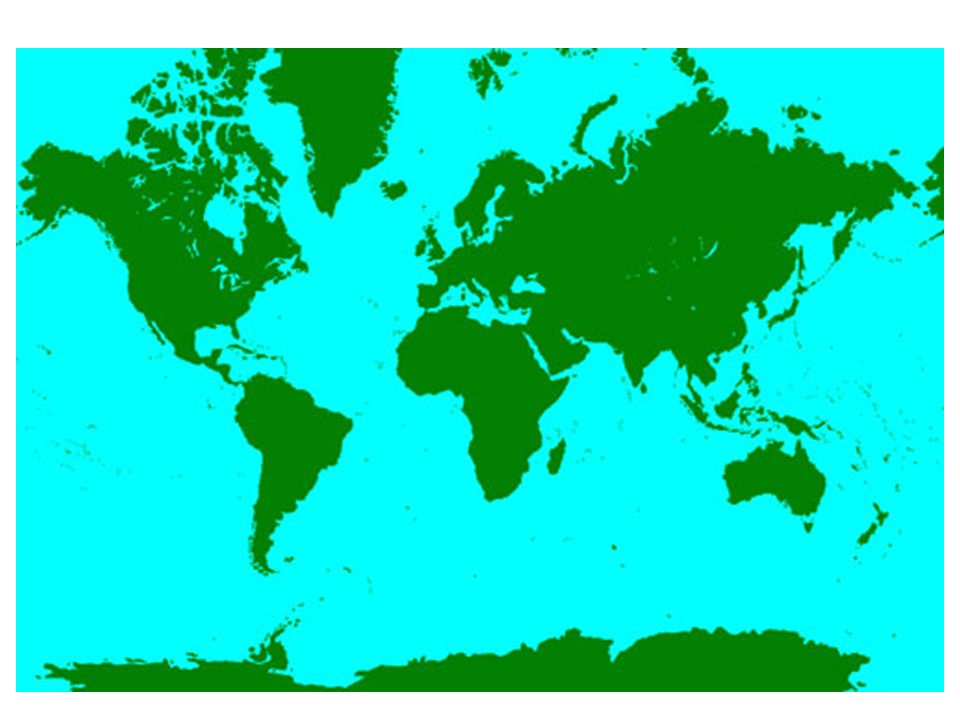
Types of Projections ALL map projects are distorted views of the earth’s surface!!! *A globe is the only accurate method to represent the earth because it is a sphere just like the earth The Mercator Projection is one particular map which is very distorted –To make a flat map from a round globe, cartographers ‘unwrapped’ the globe and stretched the northern (and southern) regions to make them flat –All lines of latitude and longitude are seen as straight lines –Created by the British as accurate naval navigation charts
 regions to make them flat –All lines of latitude and longitude are seen as straight lines –Created by the British as accurate naval navigation charts.")
8
Types of Projections Mercator cont. The problem is that any northern nation then looks stretched and larger than it really is –i.e. Canada, Greenland, Europe look BIG, while Africa, South America and other equatorial regions look smaller

9
Types of Projections The Winkel Tripel (1998) projection attempts to correct the distortions seen on maps –Curved lines of latitude and longitude show less distortion in the size of the northern regions –Gives us a less ethnocentric view of the world
 projection attempts to correct the distortions seen on maps –Curved lines of latitude and longitude show less distortion in the size of the northern regions –Gives us a less ethnocentric view of the world")
11
An odd map???

12
Types of Maps General Purpose Maps Provide many different types of information on one map –i.e. roads, hospitals, rivers, cities, forests… –Examine figure 11 (page 11) Thematic Maps Provide information on one specific characteristic or topic –I.e. elevation, vegetation, population density… –Examine figure 16 (page 18), Figure 3.10 (page 59) »***Types of Maps WS
 Thematic Maps Provide information on one specific characteristic or topic –I.e. elevation, vegetation, population density… –Examine figure 16 (page 18), Figure 3.10 (page 59) »***Types of Maps WS.")
13
General Purpose Map Ottawa Road map

14
Thematic Map: Poverty Rates

15
Compass Points and Bearings Compass points are used to show general direction North is always identified on any map created Cardinal Points: N, E, S, W Ordinal Points: NNE, NE, ENE, ESE, SE…

16
Compass Points and Bearings Bearing Points are given in exact degrees measuring angles »***Compass Points WS

17
Grid Systems Alphanumeric Grids ‘Uses letters and numbers to identify squares in a grid pattern’ letters and numbers always refer to either a row or column of squares –i.e. A12, K5, Q18… –Examine figure 11 (page 11) »***Alpha Numeric WS
 »***Alpha Numeric WS.")
18
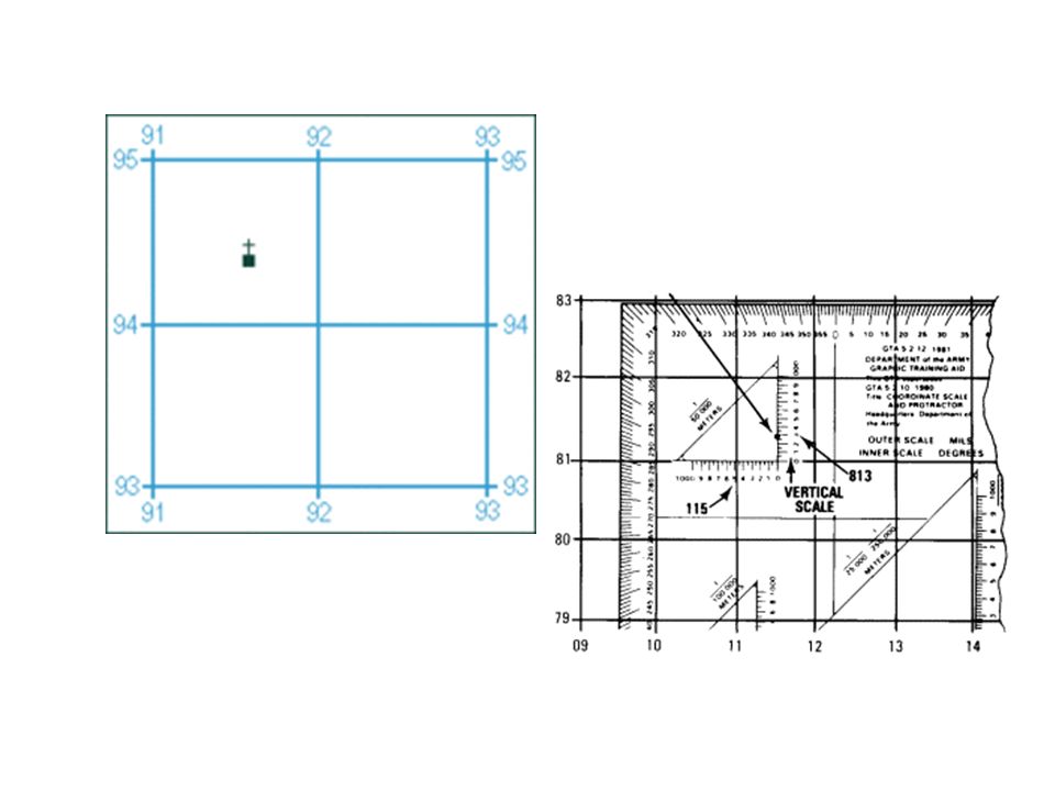
Grid Systems Military Grids Use 6 digit numbers to identify specific locations on map grids Numbers are used as ‘Eastings’ and ‘Northings’ to locate items on a map Numbers refer to the grid lines that appear on the map Always read towards the east first, then up towards the north (RRU) Each grid number is also broken down into tenths –I.e. 834095 –***Military Grid WS

20
Latitude and Longitude No matter where you are on the face of the earth, your location can be identified by your latitude and longitude coordinate (address) Read the vertical axis N or S (latitude) first, then horizontal axis E or W (longitude) second
 Read the vertical axis N or S (latitude) first, then horizontal axis E or W (longitude) second")
21
Latitude and Longitude Latitude lines: measure how far north or south a place is The equator is the starting point for all lines of latitude –All latitude lines run east-west around the globe –Ottawa is located 45 degrees north of the equator

22
Latitude and Longitude Longitude lines: measure how far east or west a place is The Prime Meridian is the starting point for all the lines of longitude –All longitude lines run north-south around the globe until they meet on the reverse side at 180 degrees –Ottawa is located 75 degrees west of the prime meridian Examine figure 14 (page 16) »***Lat. Long WS

23
ScalesScales

24
Distance Scales Direct Statement Scale Use words to describe the relationship between a distance on a map and a distance on the earth’s surface –I.e. ‘1cm to 10 km’ means every 1 cm you measure on the map is 10 km in real life –Examine figure 10 (page 10)
.")
25
Distance Scales Line Scale Uses a bar or a line to show/ describe scale Easiest to use – don’t even need a ruler! –Examine figure 11 (page 11)
.")
26
Distance Scales Representative Fraction Scale Uses numbers in a ratio to explain scale 1: 50 000 means 1cm on the map = 50 000 cm on the ground 1 : 100,000 the magic #!!! 100,000cm in a km –Good because… they can be used by anyone in the world, using any unit of measure!!! –1 : 1000 = small scale VS. 1 : 5,000,000 = large scale »***Scale WS

Similar presentations