Download presentation
Presentation is loading. Please wait.

1
Chapter 7 Human Geography of Canada: Developing a Vast Wilderness
Three major groups in Canada—the native peoples, the French, and the English—have melded into a diverse and economically strong nation.

2
Chapter 7, Section 1: History and Government of Canada
French and British settlement greatly influenced Canada’s political development. Canada’s size and climate affected economic growth and population distribution.

3
The First Settlers and Colonial Rivalry A. Early Peoples
After Ice Age, migrants cross Arctic land bridge from Asia 1. ancestors of Arctic Inuit (Eskimos); North American Indians to south 2. Vikings found Vinland (Newfoundland) about A.D. 1000; later abandon
; North American Indians to south. 2. Vikings found Vinland (Newfoundland) about A.D. 1000; later abandon.")
4
B. Colonization by France and Britain 1
B. Colonization by France and Britain 1. French explorers claim much of Canada in 1500–1600s as “New France” 2. British settlers colonize the Atlantic Coast 3. Coastal fisheries and inland fur trade important to both countries 4. Britain wins French and Indian War (1754–1763); French settlers stay
; French settlers stay q=new+france+map+1600s&um=1&hl=en&tbm=isch&tbnid=6PTW2i87bQx9GM:&imgrefurl.")
5
A. Establishing the Dominion of Canada
II. Steps Toward Unity A. Establishing the Dominion of Canada 1. In 1791 Britain creates two political units called provinces a. Upper Canada (later, Ontario): English-speaking, Protestant b. Lower Canada (Quebec): French-speaking, Roman Catholic c. Rupert’s Land a northern area owned by fur-trading company 2. Immigrants arrive, cities develop: Quebec City, Montreal, Toronto a. railways, canals are built as explorers seek better fur-trading areas
: English-speaking, Protestant. b. Lower Canada (Quebec): French-speaking, Roman Catholic. c. Rupert’s Land a northern area owned by fur-trading company. 2. Immigrants arrive, cities develop: Quebec City, Montreal, Toronto. a. railways, canals are built as explorers seek better fur-trading areas.")
6
3. Political, ethnic disputes lead to Britain’s 1867 North America Act
a. creates Dominion of Canada as a loose confederation (political union) b. Ontario, Quebec, Nova Scotia, New Brunswick c. self-governed part of British Empire 4. Expansion includes: a. Rupert’s Land, Manitoba, British Columbia, Prince Edward Island b. later: Yukon Territory, Alberta, Saskatchewan c. Newfoundland in 1949
 b. Ontario, Quebec, Nova Scotia, New Brunswick. c. self-governed part of British Empire. 4. Expansion includes: a. Rupert’s Land, Manitoba, British Columbia, Prince Edward Island. b. later: Yukon Territory, Alberta, Saskatchewan. c. Newfoundland in")
7
III. Continental Expansion and Development
A. From the Atlantic to the Pacific 1. In 1885 a transcontinental railroad goes from Montreal to Vancouver 2. European immigrants arrive and Yukon gold brings fortune hunters a. copper, zinc, silver also found; grow towns, railroads

8
B. Urban and Industrial Growth
1. Farming gives way to urban industrialization, manufacturing a. within 100 miles of U.S. border due to climate, land, transportation 2. Canada becomes major economic power in 20th century

9
A. The Parliamentary System
IV. Governing Canada A. The Parliamentary System 1. In 1931 Canada becomes independent, British monarch is symbolic head 2. Parliamentary government: a. parliament—legislature combining legislative and executive functions b. consists of an appointed Senate, elected House of Commons c. prime minister, head of government, is majority party leader 3. All ten provinces have own legislature and premier (prime minister) a. federal government administers the territories Stephen Harper is the current Prime Minister of Canada.
 a. federal government administers the territories. Stephen Harper is the current Prime Minister of Canada. page=2.")
10
Section 2: Economy and Culture of Canada
Winnipeg Vancouver Toronto

11
The Early Fur Trade in 1500s Native Americans, (First Nations) begin trade with European fishermen along Atlantic coast French and English trappers and traders expand westward Voyageurs—French-Canadian boatmen transport pelts to trading posts

12
I. An Increasingly Diverse Economy
* highly industrialized and urbanized, one of the world’s most developed economies. * a diverse people. A. Canada’s Primary Industries 1. Farming, logging, mining, fishing: 10% of gross domestic product a. Canada is the world’s leading exporter of forest products 2. Mining: uranium, zinc, gold, and silver are exported 3. Fishing: domestic consumption is low, so most of catch is exported

13
B. The Manufacturing Sector
1. 15% of Canadians work in manufacturing, create 1/5 of GDP a. make cars, steel, appliances, equipment (high-tech, mining) b. centered in heartland, from Quebec City, Quebec, to Windsor, Ontario
 b. centered in heartland, from Quebec City, Quebec, to Windsor, Ontario.")
14
C. Service Industries Drive the Economy 1
C. Service Industries Drive the Economy 1. Most Canadians work in service industries, which create 60% of GDP a. finance, utilities, trade, transportation, communication, insurance b. land’s natural beauty makes tourism the fastest growing service 2. Heavy trade with U.S.: same language, open border (world’s longest) a North American Free Trade Agreement (NAFTA) with U.S., Mexico b. 85% of Canadian exports go to U.S. c. 75% of Canada’s imports come from U.S.
 a North American Free Trade Agreement (NAFTA) with U.S., Mexico b. 85% of Canadian exports go to U.S. c. 75% of Canada’s imports come from U.S.")
15
Hello! Bonjour! II. A Land of Many Cultures A. Languages and Religions
1. Mixing of French and native peoples created métis culture 2. Bilingual: English is most common, except in French-speaking Quebec 3. English Protestants and French Catholics dominate, but often clash a. increasing numbers of Muslims, Jews, other groups Bonjour! Hello!

16
1. Densest in port cities (Montreal, Toronto, Vancouver) and farmlands
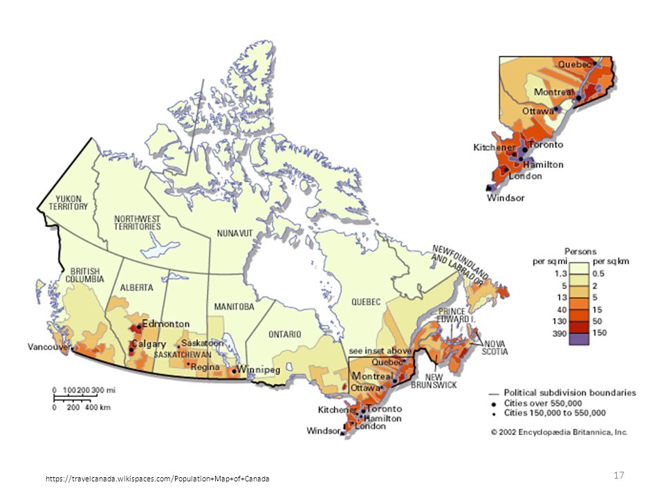
B. Canada’s Population 1. Densest in port cities (Montreal, Toronto, Vancouver) and farmlands 2. Environment keeps 80% of people on 10% of land (near U.S. border) 3. Urbanization: in % of people lived in cities, today it’s 80% 4. Various ethnic groups cluster in certain areas a. 75% of French Canadians live in Quebec b. many native peoples live on reserves—public land set aside for them c. most Inuits live in the remote Arctic north d. many Canadians of Asian ancestry live on West Coast
 and farmlands. 2. Environment keeps 80% of people on 10% of land (near U.S. border) 3. Urbanization: in % of people lived in cities, today it’s 80% 4. Various ethnic groups cluster in certain areas. a. 75% of French Canadians live in Quebec. b. many native peoples live on reserves—public land set aside for them. c. most Inuits live in the remote Arctic north. d. many Canadians of Asian ancestry live on West Coast.")
17
https://travelcanada.wikispaces.com/Population+Map+of+Canada
18
III. Life in Canada Today
A. Employment and Education 1. Relatively high standard of living, well-educated population 2. Labor force is 55% men, 45% women a. 75% in service industries, 15% in manufacturing b. Oldest university, Laval, established in Quebec by French c. English universities founded in Nova Scotia, New Brunswick in 1780s d. Today, Canada has a 97% literacy rate

19
B. Sports and Recreation
1. Popular sports: skating, ice hockey, fishing, skiing, golf, hunting a. Canada has own football league; other pro teams play in U.S. leagues b. native peoples developed lacrosse, European settlers developed hockey 2. Annual festivals include Quebec Winter Carnival, Calgary Stampede

20
C. The Arts 1. Earliest literature from oral traditions of First Nations peoples 2. Later writings from settlers, missionaries, explorers 3. Early visual arts seen in Inuit carving, West Coast totem poles 4. Early 1900s painting: unique style of Toronto’s Group of Seven 5. Shakespeare honored at Ontario’s world-famous Stratford Festival

21
Section 3: Sub regions of Canada
Canada is divided into four sub regions: the Atlantic, Core, Prairie Provinces, and the Pacific Province and the Territories. Each sub region possesses unique natural resources, landforms, economic activities, and cultural life.

22
I. The Atlantic Provinces A. Harsh Lands and Small Populations 1
I. The Atlantic Provinces A. Harsh Lands and Small Populations 1. Eastern Canada’s Atlantic Provinces: a. Prince Edward Island b. New Brunswick c. Nova Scotia d. Newfoundland 2. Only 8% of Canada’s population, due to rugged terrain, harsh weather

23
3. Most people live in coastal cities such as: a. Halifax b
3. Most people live in coastal cities such as: a. Halifax b. Nova Scotia c. St. John d. New Brunswick 4. 85% of Nova Scotia has rocky hills, poor soil 5. 90% of New Brunswick is forested 6. Newfoundland has severe storms

24
B. Economic Activities 1. New Brunswick’s largest industry: logging (lumber, wood pulp, paper) 2. Gulf of St. Lawrence, coastal waters supply seafood for export 3. Nova Scotia: logging, fishing, shipbuilding, trade through Halifax 4. Newfoundland: fishing, mining, logging, hydro-electric power

25
II. The Core Provinces—Quebec and Ontario
A. The Heartland of Canada 1. Quebec City: French explorer Samuel de Champlain built fort in 1608 2. 60% Canada’s population live in Core Provinces Ontario and Quebec a. Ontario has largest population; Quebec has largest land area

26
C. Canada’s Political and Economic Center 1
C. Canada’s Political and Economic Center 1. Ottawa, Ontario is the national capital 2. Quebec has great political importance in French-Canadian life 3. Core: 35% of Canada’s crops, 45% of minerals, 70% of manufacturing 4. Toronto the largest city, finance hub; Montreal second largest city The Rideau Canal in Ottawa freezes during the winter, and is used for ice skating!

27
III. The Prairie Provinces A. Canada’s Breadbasket
1. Great Plains Prairie Provinces: Manitoba, Saskatchewan, Alberta 2. 50% of Canada’s agricultural production, 60% of mineral output a. Alberta has coal, oil deposits; produces 90% of Canada’s natural gas

28
B. A Cultural Mix 1. Manitoba: Scots-Irish, Germans, Scandinavians, Ukrainians, Poles 2. Saskatchewan’s population includes Asian immigrants, Métis 3. Alberta’s diversity includes Indian, Japanese, Lebanese, Vietnamese

29
IV. The Pacific Province and the Territories A. British Columbia
1. westernmost province, mostly in Rocky Mountains a. 1/2 is forests; 1/3 is frozen tundra, snowfields, glaciers 2. Most people live in southwest; major cities are Victoria, Vancouver 3. Economy built on logging, mining, hydroelectric power a. Vancouver is Canada’s largest port, has prosperous shipping trade

30
1. The three northern territories account for 41% of Canada’s land
B. The Territories 1. The three northern territories account for 41% of Canada’s land 2. Sparsely populated due to rugged land and severe climate a. Yukon has population of 30,000; mostly wilderness b. Northwest Territories has population of 41,000; extends into Arctic c. Nunavut was created from Northwest Territories in 1999; home to Inuit i. Territories’ economies include mining, fishing, some logging

31
Bibliography Mcdougal Littell, World Geography. Houghton Mifflin Company. 2012

Similar presentations


>")