Download presentation
Presentation is loading. Please wait.

2
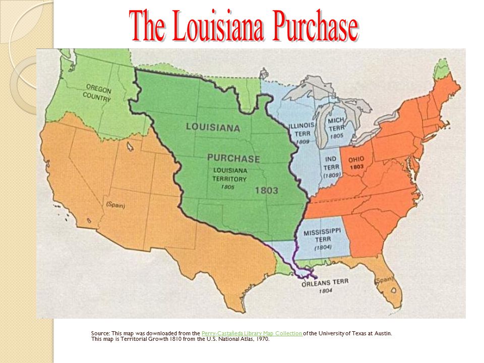
Source: This map was downloaded from the Perry-Castañeda Library Map Collection of the University of Texas at Austin. This map is Territorial Growth 1810 from the U.S. National Atlas, 1970.Perry-Castañeda Library Map Collection

3
Napoleon dreamed of an empire in the New World After losing the French and Indian war, the port of New Orleans was turned over to Spain, but in a secret treaty, they returned it to France and Napoleon planned to colonize the American territory. Just before turning it over to France, Spain closed the port to American shipping. 3/8 of the shipping of the U.S. was through the port of New Orleans and the US threatened to go to war with France and Spain. Napoleon’s had just lost an attempt to colonize the West Indies, (Toussaint L’Ouverture) and lost interest in colonizing the Americas. He decided to sell of all of Louisiana to the United States for $15 million. Napoleon’s Failed attempt to conquer the world
 and lost interest in colonizing the Americas. He decided to sell of all of Louisiana to the United States for $15 million. Napoleon’s Failed attempt to conquer the world.")
4
Because Jefferson was a strict contitutionalist, he was troubled. The constitution did not say anything about the President’s right to buy land BUT, his idea of a country of small farms needed land to expand. Jefferson would end up using the Necessary and Proper Clause [Article I, Section 8, Clause 18] that he despised. Ironically the Federalist argued against the purchase. Their main concern was the addition of more voters for the Jeffersonian Republicans. Should the US Buy the Louisiana Purchase?

5
Results of The Louisiana Territory 1. The U.S. doubled its size and acquired 800,000 square miles for three cents per acre 2. The U.S. received the western half of the richest river valley in the world 3. We were guaranteed the Mississippi waterway to the Gulf of Mexico included Port of New Orleans 4. It would pave the way for the westward expansion of the United States

6
The Lewis and Clark Expedition The plan for the expedition was actually laid out before the actual purchase was made. The leaders of this “Corps of Discovery” would be Meriwether Lewis and William Clark. ◦ Lewis was a former army captain who had been an assistant to President Jefferson. ◦ Clark had fought as a military man against Indians of the Ohio Valley. Sacagawea, a Shoshone female, became scout and translator when the group reached Bismarck, South Dakota for the winter. She would be crucial in helping the expedition succeed.

7
The group set out in May of 1804 from a spot near St. Louis. The trail extended from the Missouri River through the Rockies and along the Columbia River to the Pacific Ocean. The expedition would give basis for the U.S. claim to Oregon. It would open the West to trade and exploration.

8
Disprove the mysteries of the West. ◦ Woolly mammoths, unicorns, and seven-foot tall beavers. ◦ Some maps showed California as an island. ◦ There was still hope for finding a “northwest passage” Record what actually WAS there. ◦ Make maps. ◦ Record landforms and bodies of water. ◦ Recorded plant and animal life in the Louisiana area.

9
Zebulon Pike was sent out to search the headwaters of the Mississippi River to find the origin of the Missouri River. Pike set out in August of 1805 from Fort Bellfontaine, near St. Louis. Between 1806-1807, Pike went into Colorado and New Mexico. Pike sighted Pike’s peak in Colorado. www.wallpaperdave.com/pike.htm Fun Fact (AKA other exploration at the same time)
.")
10
How did the Louisiana Purchase contribute to the economic growth of the United States?

11
WAR OF 1812 Although The Louisiana Purchase opened up more trade opportunities for the United States, it would lead to problems with Britain.

12
Causes of War of 1812 England partially blocked American ports ◦ Only allowed some American ships to bring provisions to Europe which angered France and put American merchants in a difficult position. ◦ American sea trade suffered British Impressment of Sailors ◦ British kidnapped American sailors to work on British ships.

13
Madison Declares War! England didn’t really want to go to war with US because they were already fighting France British announced they wouldn’t interfere with US trade, but US did not get the information until several weeks after declaring war. (Mail was slow!)
.")
14
WAR OF 1812 In the beginning, England is also at war with France. Us Navy was small, but still won great victories. British burned the Capitol building and President’s mansion and attacked Fort McHenry In December, 1814, dozens of British ships and 7500 British troops approached Louisiana.

15
Battle of New Orleans Americans put together an army under the command of General Andrew Jackson. Jackson was victorious! Although it made Jackson a hero, the battle was unnecessary. The Treaty of Ghent, which ended the war, had been signed two weeks earlier on Christmas Eve. Slow mail (AGAIN)!
!.")
16
FUN FACT! During one of the battles (Fort McHenry), Francis Scott Key wrote “The Star Spangled Banner”. During one of the battles (Fort McHenry), Francis Scott Key wrote “The Star Spangled Banner”. He watched the all night battle and was encouraged at dawn, when he saw the flag still flying, to express his pride in song. He watched the all night battle and was encouraged at dawn, when he saw the flag still flying, to express his pride in song.
, Francis Scott Key wrote The Star Spangled Banner . During one of the battles (Fort McHenry), Francis Scott Key wrote The Star Spangled Banner . He watched the all night battle and was encouraged at dawn, when he saw the flag still flying, to express his pride in song. He watched the all night battle and was encouraged at dawn, when he saw the flag still flying, to express his pride in song..")
17
Effects of War of 1812 Increased patriotism Broke the strength of the Native Americans (they had sided with the British) MOST IMPORTANTLY ◦ The interruption of trade forced Americans to make their own goods. ◦ This encouraged the growth of US manufacturers and will lead to the Industrial Revolution.

18
CLOSING QUESTION Would you agree that the War of 1812 should be called the “Second War for Independence”? Explain your answer.

Similar presentations

 I.Intro II.Jefferson (1801-1809) “The Man” III.Louisiana A.Purchase B.Exploration IV.Madison (1809-1817) A.War Of 1812 1.Background.>")

Thomas Jefferson Chapter 9 Notes B)Westward Expansion>")


