Download presentation
Presentation is loading. Please wait.

1
THIS DOCUMENTS CONTAINS ALL THE CLASS NOTES WE HAVE DONE SO FAR.
IT IS HERE FOR REFERENCE ONLY YOU ONLY NEED TO STUDY THE MATERIALS IN THE STUDY GUIDE IN THE HANDOUTS FOLDER FOR THE OCTOBER 6 QUIZ DON’T PRINT THIS DOCUMENT – IT’S TOO LONG WELCOME G6 STUDENTS

2
English Social Studies Kuwait and the Arab World Book 3
Mr. Stewart

3
Physical Characteristics of the Arab World
Geographic Location North & East Africa & South West Asia Coordinates: Latitude 2° South and 37° North Longitude 17° West and 60° East

4
September 15, 2015 DO NOW Definitions: Waterways Trade Exports Imports
Population Cradle

5
Definitions: Waterways a river, sea, canal, or other route for travel by water Trade the action of buying and selling goods and services Export send (goods or services) to another country for sale Import bring (goods or services) into a country from abroad for sale Population all the inhabitants of a particular place or who share similarities Cradle the place of origin of
 to another country for sale. Import. bring (goods or services) into a country from abroad for sale. Population. all the inhabitants of a particular place or who share similarities. Cradle. the place of origin of.")
6
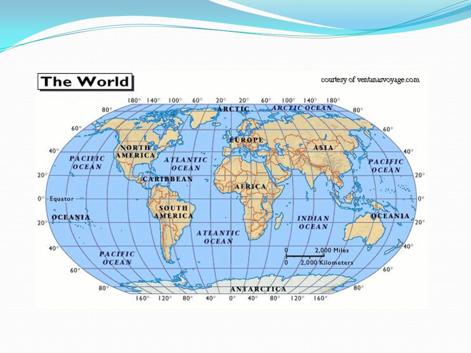
World Continents and Oceans

8
Countries of the Arab World

9
Physical Characteristics of the Arab World
Comprised of 22 countries - Biggest by area: Sudan - Biggest by population: Egypt - Smallest: Bahrain

10
Map of the Arab World

11
Seas of the Arab World Seas Bordering the Arab World:
Atlantic Ocean (west), Arabian Gulf (east) Indian Ocean (south east) Mediterranean (north) The Red Sea (east of Africa/ west of Saudi Arabia) The Gulf of Oman (south east) Straight of Hurmuz (south east)
, Arabian Gulf (east) Indian Ocean (south east) Mediterranean (north) The Red Sea (east of Africa/ west of Saudi Arabia) The Gulf of Oman (south east) Straight of Hurmuz (south east)")
12
Importance of the Arab World
Central location Linking Asia, Europe and East Africa Important trade routes by sea or land Cradle of three religions: Judaism, Christianity and Islam Central Location helped the spread of these religions Example: Islam spread as far as China and Spain

13
Importance in Recent Times
Importance increased significantly in recent times Arab World is biggest exporter of oil and has most of the worlds oil reserves Most industrial countries like Japan, USA and the countries of Europe depend mainly on Arab oil

14
How Trade Routes Through the Arab World Connected Continents

15
September 20, 2015 Do Now Topography, Plain, Plateau, Coast Sediment
the arrangement of the natural and artificial physical features of an area Plain, a large area of flat land with few trees Plateau, an area of fairly level high ground Coast the part of the land adjoining or near the sea Sediment the accumulation of sand and dirt that settles in the bottom of lakes

16
September 20, 2015 Classwork (see homework below)
What is topography? Describes the surface features of a region or area of land Includes the natural and artificial physical features of an area Three main topographic features of the Arab World Plains Plateaus Mountains

17
Topography of Arab World

18
Topography of Arab World 2

19
Plains (two main kinds)
1. Coastal Plains: Flat areas of land usually along the coast: EXAMPLES: Morocco, Algeria (between Atlas mountains and the Mediterranean Sea) - North Africa (Egypt, Libya) - North, East and South Arabian Gulf and Oman 2. Fluvial Plains Created by sediment from rivers EXAMPLES: River Nile Delta, Plains between the Tigris and Euphrates Rivers
 - North Africa (Egypt, Libya) - North, East and South Arabian Gulf and Oman. 2. Fluvial Plains. Created by sediment from rivers. EXAMPLES: River Nile Delta, Plains between the Tigris and Euphrates Rivers.")
20
Coastal plains are very important natural
Intertidal areas provide habitat for many birds, plants and marine life (crabs, snails, shellfish, fish etc – food source for other bigger fish) Plains provide fertile farming and feeding grounds for migrating birds Vegetation is adapted to temperature and salty of water – provides feeding for animals, birds and other life (eg; BETWEEN Doha and Kuwait City)
 Plains provide fertile farming and feeding grounds for migrating birds. Vegetation is adapted to temperature and salty of water – provides feeding for animals, birds and other life. (eg; BETWEEN Doha and Kuwait City)")
21
Coastal Plains Kuwait & Morocco

22
Coastal plain agriculture

23
Birds in Kuwait Costal Plains

24
Animals grazing in Kuwait

25
Coastal plains are very important resting places for migrating birds

26
Bird Migration Routes They need plains to stop, rest and feed.

27
Fluvial Plains Egypt (R. Nile) & Iraq (R. Tigris)
 & Iraq (R. Tigris)")
28
Plateaus High areas with mostly flat tops
Largest plateau is Sahara Desert ( meters high) Najd Plateau covers most of Saudi Arabia (maximum height 1500) In Arab World plateaus are mostly dry deserts with sand dunes and some oasis.
 Najd Plateau covers most of Saudi Arabia (maximum height 1500) In Arab World plateaus are mostly dry deserts with sand dunes and some oasis.")
29
Najd Plateau in Saudi Arabia

30
Najd Plateau in Saudi Arabia

31
Mountains There are four main mountain ranges in the Arab World:
1. Atlas Mountains – (height 4165 m) – Across Morocco, Algeria and Tunisia 2. Oman Mountains (height 3000 m) South East of Arabian Peninsula 3. Al Hejaz Mountains (height 3000 m) West Saudi Arabia and Yemen 4. Lebanese Mountains (height 3088 m)
 – Across Morocco, Algeria and Tunisia. 2. Oman Mountains (height 3000 m) South East of Arabian Peninsula. 3. Al Hejaz Mountains (height 3000 m) West Saudi Arabia and Yemen. 4. Lebanese Mountains (height 3088 m)")
32
Atlas Mountains

33
Al Hejaz Mountains

34
September 20, Homework Print the world map in the handouts folder (Name: Grade 6 MENA map): Fill in the names of the Arab countries (as shown in class) Find the following rivers: - River Nile - Tigris and Euphrates Rivers Mark them in blue USE THE MAP ON PAGE 16 OR TOPOGRAPHY MAP IN YOUR HANDOUTS Color in the Coastal and Fluvial plains in North Africa and Arabian Peninsula in green Color in the plateaus in yellow Color in the mountains in brown DUE Tuesday September 29
 Find the following rivers: - River Nile. - Tigris and Euphrates Rivers. Mark them in blue. USE THE MAP ON PAGE 16 OR. TOPOGRAPHY MAP IN YOUR HANDOUTS. Color in the Coastal and Fluvial plains in North Africa and Arabian Peninsula in green. Color in the plateaus in yellow. Color in the mountains in brown. DUE Tuesday September 29.")
35
Map of the World

37
September 29, 2015 Do Now – Definitions (hand in homework)
Climate the weather conditions in an area in general or over a long period of time Latitude Imaginary lines that cross the earth horizontally used for location and navigation Equator An imaginary line across the earth exactly between the north and south poles Altitude Height from sea the ground or sea level Dominant The most common feature or description of something

38
Climate of the Arab World
Climate is affected by several factors: Latitude – areas near the equator usually hotter Balance of land and water: water controls temperature and holds heat – more humidity more heat / less changes between hot al cold. Altitude – temperatures become cooler in higher altitudes

39
Climate Zones of the Arab World
There are three main climates in the Arab World: 1. Mediterranean 2. Desert 3. Tropical

40
1. Mediterranean Climate
High temperatures, low rainfall in summer Warm and rainy winters Mostly around the Mediterranean Sea

42
Mediterranean Climates in the World

43
2. Desert Climate Covers large areas of north Africa (Sahara desert) and most of the Arabian Peninsula High temperatures with no rain in summer Lower temperatures in winter and limited rainfall

45
Desert Climates in the World

46
3. Tropical Climate Very hot and wet through most of the year
Found mostly in Southern Sudan, Somalia, Mauritania and some parts of Oman and Yemen

48
Climate Zones of the World

Similar presentations


>")


