Download presentation
Presentation is loading. Please wait.

1
Ocean Circulation

2
Five Main Concepts Ocean circulation is driven by winds and by differences in water density. Along with the winds, ocean currents distribute tropical heat worldwide. Surface currents are wind-driven movements of water at or near the ocean’s surface. Thermohaline currents (so named because they depend on density differences caused by variations in water’s temperature and salinity) are the slow, deep currents that affect the vast bulk of seawater beneath the pycnocline. Large surface currents move in circular circuits—gyres—along the peripheries of major ocean basins. Wind-driven water moving in a gyre is dynamically balanced between Coriolis effect and the force of gravity.
 are the slow, deep currents that affect the vast bulk of seawater beneath the pycnocline. Large surface currents move in circular circuits—gyres—along the peripheries of major ocean basins. Wind-driven water moving in a gyre is dynamically balanced between Coriolis effect and the force of gravity.")
3
Five Main Concepts El Niño and La Niña affect ocean and atmosphere. El Niño is an exception to normal wind and current flow. Water masses form at the ocean surface. Water masses often retain their distinct properties as they sink and sort into identifiable layers.

4
Mass Flow of Ocean Water Is Driven by Wind and Gravity
I. Surface Currents Mass Flow of Ocean Water Is Driven by Wind and Gravity Currents are the mass flow of water. Surface currents are wind-driven movements of water at or near the ocean’s surface. (horizontal movement of water) Thermohaline currents are the slow, deep currents that affect the vast bulk of seawater beneath the pycnocline. (vertical movement of water) Both have very important influences on Earth’s temperature, climate, and biological productivity, and will change as Earth’s climate varies.
 Thermohaline currents are the slow, deep currents that affect the vast bulk of seawater beneath the pycnocline. (vertical movement of water) Both have very important influences on Earth’s temperature, climate, and biological productivity, and will change as Earth’s climate varies.")
5
Surface Currents Are Driven by the Winds
I. Surface Currents Surface Currents Are Driven by the Winds Winds, driven by uneven solar heating and Earth’s spin, drive the movement of the ocean’s surface currents. About 10% of the water in the world ocean is involved in surface currents. These currents are driven mainly by wind friction.

6
Surface Currents Are Driven by the Winds (cont’d.)
I. Surface Currents Surface Currents Are Driven by the Winds (cont’d.) A combination of four forces: surface winds, the sun’s heat, the Coriolis effect, and gravity form circular currents called gyres. Gyres circulate: Clockwise in the Northern Hemisphere Counterclockwise in the Southern Hemisphere.
 A combination of four forces: surface winds, the sun’s heat, the Coriolis effect, and gravity form circular currents called gyres. Gyres circulate: Clockwise in the Northern Hemisphere. Counterclockwise in the Southern Hemisphere.")
7
Surface Currents Are Driven by the Winds (cont’d.)
I. Surface Currents Surface Currents Are Driven by the Winds (cont’d.) The North Atlantic gyre, a series of four interconnecting currents with different flow characteristics and temperatures.
 The North Atlantic gyre, a series of four interconnecting currents with different flow characteristics and temperatures.")
8
Surface Currents Flow around the Periphery of Ocean Basins
I. Surface Currents Surface Currents Flow around the Periphery of Ocean Basins Surface water blown by the winds at point A will veer to the right of its initial path and continue eastward. Water at point B veers right and continues westward.

9
Surface Currents Flow around the Periphery of Ocean Basins (cont’d.)
I. Surface Currents Surface Currents Flow around the Periphery of Ocean Basins (cont’d.) The Ekman spiral model. A body of water can be thought of as a set of layers. Each layer below is moved by friction. Each succeeding layer moves with a slower speed and at an angle to the layer immediately above. The theoretical net flow of water in the Northern Hemisphere is 90° to the prevailing wind force.
 The Ekman spiral model. A body of water can be thought of as a set of layers. Each layer below is moved by friction. Each succeeding layer moves with a slower speed and at an angle to the layer immediately above. The theoretical net flow of water in the Northern Hemisphere is 90° to the prevailing wind force.")
10
I. Surface Currents Nansen (captain of the Fram) noticed that ice does not flow with the wind. Upon his return from the voyage, Nansen consulted his physicist/mathematician friend, Ekman, who looked at the oddity and came up with the relationship that explained the unexpected direction of water movement

11
Surface Currents Flow around the Periphery of Ocean Basins (cont’d.)
I. Surface Currents Surface Currents Flow around the Periphery of Ocean Basins (cont’d.)
")
12
Wind force Direction of motion Friction Stepped Art
Figure 9.5 The Ekman spiral and the mechanism by which it operates. The length of the arrows in the diagrams is proportional to the speed of the current in each layer. Stepped Art Figure 9-5b p266

13
Surface Currents Flow around the Periphery of Ocean Basins (cont’d.)
I. Surface Currents Surface Currents Flow around the Periphery of Ocean Basins (cont’d.) The Ekman spiral model. (cont’d.) The effect of Ekman spiraling and the Coriolis effect cause the water within a gyre to move in a circular pattern. The movement of water away from point B is influenced by the rightward tendency of the Coriolis effect and the gravity-powered movement of water down the pressure gradient.
 The Ekman spiral model. (cont’d.) The effect of Ekman spiraling and the Coriolis effect cause the water within a gyre to move in a circular pattern. The movement of water away from point B is influenced by the rightward tendency of the Coriolis effect and the gravity-powered movement of water down the pressure gradient.")
14
Trade wind Water continues clockwise? 90° to the right of wind
direction is up here Water continues clockwise? Trade wind Direction of water movement 30°– 45° At 15°N Figure 9.6 The movement of water away from point B in Figure 9.4 is influenced by the rightward tendency of the Coriolis effect and the gravity-powered movement of water down the pressure gradient. Stepped Art Figure 9-6 p267

15
Surface Currents Flow around the Periphery of Ocean Basins (cont’d.)
I. Surface Currents Surface Currents Flow around the Periphery of Ocean Basins (cont’d.) The Ekman spiral model. (cont’d.) The surface of the North Atlantic is raised through wind motion and Ekman transport to form a low hill. The westward-moving water is balanced between the Coriolis effect and flow down the pressure gradient, driven by gravity. Thus, water in a gyre moves along the outside edge of an ocean basin.
 The Ekman spiral model. (cont’d.) The surface of the North Atlantic is raised through wind motion and Ekman transport to form a low hill. The westward-moving water is balanced between the Coriolis effect and flow down the pressure gradient, driven by gravity. Thus, water in a gyre moves along the outside edge of an ocean basin.")
16
Ekman Spiral and transport con’t
The raised surface is caused by the converging currents. As the trade winds and the westerlies push the ocean, the water moves at 90 degrees from wind direction. This causes a convergence of currents at around 30 degrees latitude, this causes the water to build up in a hill. The hill causes an increase in slope of the ocean’s surface and the water flowing off of the slope or away from the crest of the hill flows faster as it flows downhill.

17
Western Intensification
In North Atlantic and North Pacific, the currents on the western side of the ocean are narrower, stronger and deeper than on the eastern side. The Kuroshio and Gulf Stream are faster and narrower than the Canary and California currents. The same amount of water travels through all of the currents, even though their dimensions are different.

18
Western Intensification occurs because:
The current is traveling from lower to higher latitudes. The eastward turning of the Earth. The increase in Coriolis effect with increasing latitude. The changing strength and direction of the east-west winds (trades and westerlies) with latitude The friction between land masses and water currents.
 with latitude. The friction between land masses and water currents.")
19
Western Intensification con’t
These factors cause a compression of the currents on the western side of the oceans where water is moving from lower to higher latitudes. This causes the current speed to increase.

20
Western Intensification con’t
On the Eastern side of the gyre, where currents are moving from higher latitudes to lower latitudes, the currents are stretched or spread out in the east-west direction. This causes the current’s speed to be reduced but still transports the same amount of water.

21
Surface Currents Flow around the Periphery of Ocean Basins (cont’d.)
I. Surface Currents Surface Currents Flow around the Periphery of Ocean Basins (cont’d.) The Ekman spiral model. (cont’d.) The hill is formed by Ekman transport. Water turns clockwise (inward) to form the dome, then descends, depressing the thermocline.
 The Ekman spiral model. (cont’d.) The hill is formed by Ekman transport. Water turns clockwise (inward) to form the dome, then descends, depressing the thermocline.")
22
Seawater Flows in Six Great Surface Circuits
I. Surface Currents Seawater Flows in Six Great Surface Circuits Geostrophic gyres are gyres in balance between the pressure gradient and the Coriolis effect. Of the six great currents in the world’s ocean, five are geostrophic gyres. A chart showing the names and usual direction of the world ocean’s major surface currents. The powerful western boundary currents flow along the western boundaries of ocean basins in both hemispheres.

23
Boundary Currents Have Different Characteristics
I. Surface Currents Boundary Currents Have Different Characteristics Western boundary currents – These are narrow, deep, fast currents found at the western boundaries of ocean basins. The Gulf Stream, Japan Current, and the Brazil Current Agulhas Current and the Eastern Australian Current Eastern boundary currents – These currents are cold, shallow and broad, and their boundaries are not well defined. The Canary Current, Benguela Current, and the California Current The West Australian Current and Peru Current

24
Eastern vs. Western Boundary Currents

25
Boundary Currents Have Different Characteristics (cont’d.)
I. Surface Currents Warm core eddies rotate clockwise, cold core eddies rotate counterclockwise in N. Hemisphere Boundary Currents Have Different Characteristics (cont’d.) The western boundary of the Gulf Stream is usually distinct, marked by abrupt changes in water temperature, speed, and direction. (a) Meanders (eddies) form at this boundary as the Gulf Stream leaves the U.S. coast at Cape Hatteras. The meanders can pinch off (b) and eventually become isolated cells of warm water (c). Likewise, cold cells can pinch off and become entrained in the Gulf Stream itself (d).
 The western boundary of the Gulf Stream is usually distinct, marked by abrupt changes in water temperature, speed, and direction. (a) Meanders (eddies) form at this boundary as the Gulf Stream leaves the U.S. coast at Cape Hatteras. The meanders can pinch off (b) and eventually become isolated cells of warm water (c). Likewise, cold cells can pinch off and become entrained in the Gulf Stream itself (d).")
26
Boundary Currents Have Different Characteristics (cont’d.)
I. Surface Currents Boundary Currents Have Different Characteristics (cont’d.) Influence of the Coriolis effect on westward intensification. Because the Coriolis effect is strongest near the poles, water flowing eastward at high latitudes turns sooner to the right. Western boundary currents are therefore faster and deeper than eastern boundary currents, and the geostrophic hill is offset to the west. Cross section of geostrophic flow in the North Atlantic.
 Influence of the Coriolis effect on westward intensification. Because the Coriolis effect is strongest near the poles, water flowing eastward at high latitudes turns sooner to the right. Western boundary currents are therefore faster and deeper than eastern boundary currents, and the geostrophic hill is offset to the west. Cross section of geostrophic flow in the North Atlantic.")
27
Surface Currents Affect Weather and Climate
II. Effects of Surface Currents on Climate Surface Currents Affect Weather and Climate General summer air circulation patterns of the east and west coasts of the United States.

28
Wind Can Cause Vertical Movement of Ocean Water
III. Upwelling and Downwelling Example of Gyre Formation and Westward Intensification EAC Digging into the Great Pacific Garbage Patch Tsunami Debris Plastic Soup Wind Can Cause Vertical Movement of Ocean Water Wind-induced vertical circulation is vertical movement induced by wind-driven horizontal movement of water. Upwelling is the upward motion of water. This motion brings cold, nutrient rich water towards the surface. Downwelling is downward motion of water. It supplies the deeper ocean with dissolved gases.

29
Nutrient-Rich Water Rises Near the Equator
III. Upwelling and Downwelling Nutrient-Rich Water Rises Near the Equator Equatorial upwelling. Water north of the equator veers to the right (northward), and water to the south veers to the left (southward). Surface water therefore diverges, causing upwelling. The red, orange, and yellow colors mark the areas of greatest upwelling as determined by biological productivity.
, and water to the south veers to the left (southward). Surface water therefore diverges, causing upwelling. The red, orange, and yellow colors mark the areas of greatest upwelling as determined by biological productivity.")
30
Wind Can Induce Upwelling Near Coasts
III. Upwelling and Downwelling Wind Can Induce Upwelling Near Coasts Coastal upwelling. In the Northern Hemisphere, coastal upwelling moves water offshore by Ekman transport is replaced by cold water. Observe how upwelling occurs (RIGHT) Satellite view of the U.S. west coast shows the growth of small, plantlike organisms stimulated by upwelled nutrients.
 Satellite view of the U.S. west coast shows the growth of small, plantlike organisms stimulated by upwelled nutrients.")
31
Wind Can Also Induce Coastal Downwelling
III. Upwelling and Downwelling Wind Can Also Induce Coastal Downwelling Wind blowing from the south along a Northern Hemisphere west coast for a prolonged period can result in downwelling. Areas of downwelling are often low in nutrients and therefore relatively low in biological productivity.

32
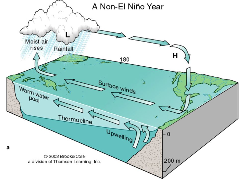
IV. El Nino and La Nina El Nino – CF In a non-El Niño year, normally the air and surface water flow westward, the thermocline rises, and upwelling of cold water occurs along the west coast of Central and South America.

34
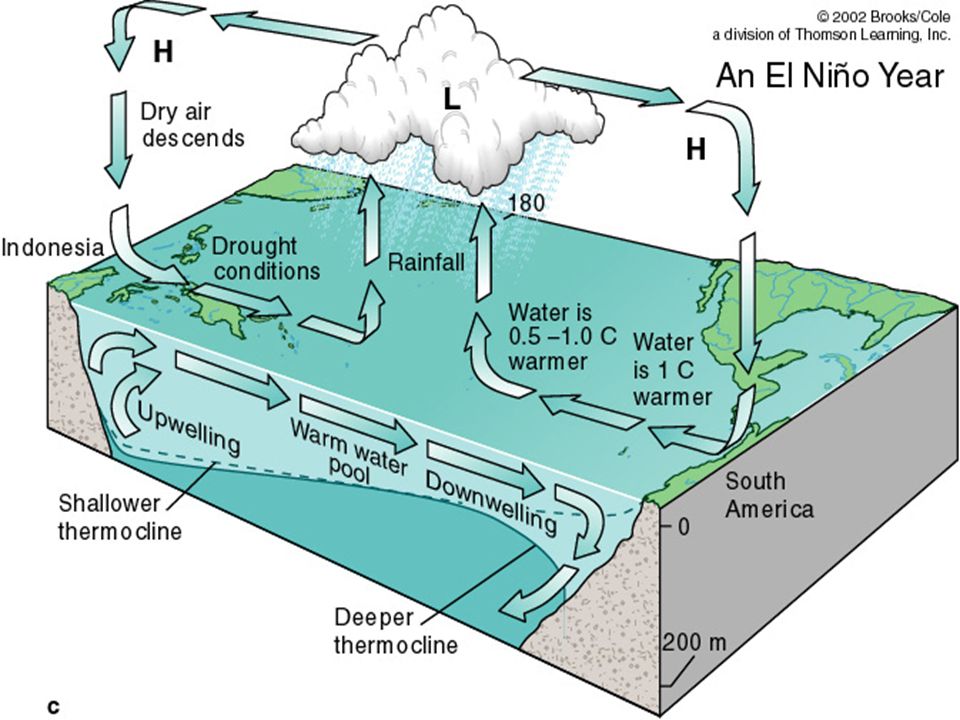
IV. El Nino and La Nina In an El Niño year, when the Southern Oscillation develops, the trade winds diminish and then reverse, leading to an eastward movement of warm water along the equator. The surface waters of the central and eastern Pacific become warmer, and storms over land may increase. El Nino Explained

36
IV. El Nino and La Nina Normal circulation sometimes returns with surprising vigor, producing strong currents, powerful upwelling, and chilly and dry conditions along the South American coast. These contrasting colder-than-normal events are called La Niña.

37
IV. El Nino and La Nina A Non-El Niño Year An El Niño Year

39
How do we track and predict El Nino?
Can be tracked in measurements of the sea surface temperature NOAA operates a network of buoys which measure temperature, currents and winds in the equatorial band. Add to notes

40
IV. El Nino and La Nina El Niño changes atmospheric circulation and weather patterns. During an El Niño, low atmospheric pressure south of Alaska allows storms to move unimpeded to the Pacific coast of North America. In La Niña years, high atmospheric pressure south of Alaska blocks the storm track.

41
Thermohaline Circulation Affects All the Ocean’s Water
V. Thermohaline Circulation Thermohaline Circulation Affects All the Ocean’s Water The movement of water due to different densities is thermohaline circulation. Because the ocean is density stratified, the densest (heaviest) water is at the bottom. There are five common water masses: Surface water Central water Intermediate water Deep water Bottom water
 water is at the bottom. There are five common water masses: Surface water. Central water. Intermediate water. Deep water. Bottom water.")
42
Thermohaline Flow and Surface Flow: The Global Heat Connection
V. Thermohaline Circulation Thermohaline Flow and Surface Flow: The Global Heat Connection The global pattern of deep circulation resembles a vast “conveyor belt” that carries surface water to the depths and back again. The whole slow-moving system is important in transporting water and heat.

43
The Surfing Scientist - Thermohaline Circulation

44
North Atlantic Deep Water Conveyer
Add to notes Sediment records show that it turns on and off Was off during the last ice age One way models suggest the conveyer could shutdown is through the introduction of freshwater from melting ice sheets In the 80’s, one source of NADW water decreased by 90% Could be related to climate change Could be a signal of the onset of an ice age

46
VI. Studying Currents Water Masses May Converge, Fall, Travel across the Seabed, and Slowly Rise Surface water becomes dense and sinks in the north and south polar regions. Being denser, Antarctic Bottom Water slips beneath North Atlantic Deep Water.

47
VI. Studying Currents Water Masses May Converge, Fall, Travel across the Seabed, and Slowly Rise (cont’d.) The water then gradually rises across a very large area in the tropical and temperate zones, then flows pole-ward to repeat the cycle.

48
VI. Studying Currents Water Masses May Converge, Fall, Travel across the Seabed, and Slowly Rise (cont’d.) Freshwater arriving in the North Atlantic from rapidly melting polar ice could slow the formation of North Atlantic Deep Water with profound implications for the climate of Europe.

49
Summary In this chapter you learned that ocean water circulates in currents. Surface currents affect the uppermost 10% of the world ocean. The movement of surface currents is powered by the warmth of the sun and by winds. Water in surface currents tends to flow horizontally, but it can also flow vertically in response to wind blowing near coasts or along the equator. Surface currents transfer heat from tropical to polar regions, influence weather and climate, distribute nutrients, and scatter organisms. They have contributed to the spread of humanity to remote islands, and they are important factors in maritime commerce. Circulation of the 90% of ocean water beneath the surface zone is driven by the force of gravity, as dense water sinks and less dense water rises. Because density is largely a function of temperature and salinity, the movement of deep water due to density differences is called thermohaline circulation. Currents near the seafloor flow as slow, river-like masses in a few places, but the greatest volumes of deep water creep through the ocean at an almost imperceptible pace. The Coriolis effect, gravity, and friction shape the direction and volume of surface currents and thermohaline circulation.

Similar presentations


>")

 EarthsClimate_Web_Chapter.pdfEarthsClimate_Web_Chapter.pdf, p. 22-24.>")