Download presentation
Presentation is loading. Please wait.

1
Monitoring Important Bird Areas in Africa: The use of GIS and Remote Sensing to complement ground-based methods Eshiamwata, G.W, Buchanan, G., Mulaku, G.C., Kiema, J.B.K SCGIS Scholar, 2007

2
An Overview Africa: Facts, figures & avifauna Important Bird Areas (IBAs) Land cover/use changes at IBAs in Africa Monitoring GIS, Remote sensing and IBA monitoring Land cover/use change analysis at Kakamega, South Nandi and North Nandi forest IBAs
 Land cover/use changes at IBAs in Africa Monitoring GIS, Remote sensing and IBA monitoring Land cover/use change analysis at Kakamega, South Nandi and North Nandi forest IBAs")
3
Africa Area: 30.3m. sq km, Africa is the world's second largest continent after Asia Population: c. 888 million people (13% of worlds population)(2005 UN) Poverty levels: over 45% living in extreme poverty High species diversity and endemism
(2005 UN) Poverty levels: over 45% living in extreme poverty High species diversity and endemism.")
4
Africa & Bird diversity Africa consists of: 2,313 (23%) of the worlds 9,917 bird species 1,400 endemic species 234 Globally threatened species
 of the worlds 9,917 bird species 1,400 endemic species 234 Globally threatened species")
5
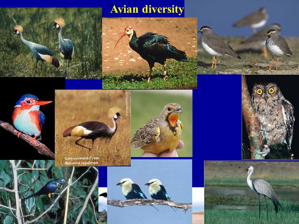
Avian diversity

7
Congregations of waterbirds

8
Bird diversity in Africa

9
Setting conservation priorities Biodiversity –not uniformly spread across the globe –resources for biodiversity conservation are limited & unevenly distributed too. The need to prioritize where conservation action should start

10
What are Important Bird Areas (IBAs)? –Places of international significance for birds and other biodiversity –Network of sites critical for bird conservation –Practical tools for conservation – discrete manageable sites IBAs of global significance have been identified based on criteria: –Species of global conservation concern –Assemblage of restricted-range species –Assemblage of biome-restricted species –Congregations BirdLife International focuses its conservation efforts at IBAs

11
The global network of IBAs identified to date Areas of the world where the process of IBA identification is still in progress

12
Identifying & Protecting IBA Sites in Africa 1, 230 IBA sites in 54 countries within Africa and its associated island have been identified

13
Deforestation for timber, forest clearance for fuel wood (& charcoal) extraction & for commercial plantations (e.g. Oil palm) affect IBAs Biodiversity: land use/cover changes at IBAs Deforestation & habitat fragmentation 5.8+/- 1.4 million ha. of humid tropical forest lost each year between 1990 & 1997 with a further 2.3+/-0.7 million ha of forest degraded
 affect IBAs Biodiversity: land use/cover changes at IBAs Deforestation & habitat fragmentation 5.8+/- 1.4 million ha. of humid tropical forest lost each year between 1990 & 1997 with a further 2.3+/-0.7 million ha of forest degraded.")
14
Expansion and intensification of agriculture Expanding agriculture destroys more habitat than any other factor Agricultural land has expanded six-fold since 1700 ( FAO, 2001) Biodiversity: land use/cover changes at IBAs
 Biodiversity: land use/cover changes at IBAs")
15
Biodiversity: land use/cover changes Fires Alien invasive species (water hyacinth, Prosopis sp Desertification

16
Biodiversity: land use/cover changes at IBAs There is an emerging urgent need to MONITOR change and keep track of trends in biodiversity

17
IBA monitoring Tell how we are doing at local, national & regional levels (Performance or audit function) : –species of interest, key sites, national IBA network Determine where action is needed Threats increasing, threats addressed, which actor to target Contribute towards global targets (CBD 2010 targets, MDGs, Assessing effectiveness of policy /legislation Detecting incipient change
 : –species of interest, key sites, national IBA network Determine where action is needed Threats increasing, threats addressed, which actor to target Contribute towards global targets (CBD 2010 targets, MDGs, Assessing effectiveness of policy /legislation Detecting incipient change")
18
State Pressure Response. Status of biodiversity, Conditions that maintain it. Identify need for intervention overview of threats across habitats, countries & regions Magnitude of investment Gaps for interventions IBA Monitoring Framework

19
A typical IBA monitoring process involves Research Data Management Information & Analysis Action

20
IBA caretakers and Site Support Groups –140 Site Support Groups have been established to contribute to the management and monitoring of at least 150 IBAs Ground-based IBA Monitoring

21
GIS & Remote sensing in IBA monitoring? Image processing & change detection analyses Can use time-series satellite data to detect & assess spatio-temporal changesCan use time-series satellite data to detect & assess spatio-temporal changes Very useful approach in land use/cover change analysis such as monitoring deforestation/regeneration at IBAsVery useful approach in land use/cover change analysis such as monitoring deforestation/regeneration at IBAs Species can be mapped and changes at IBAs correlated with species abundance, distribution Species can be mapped and changes at IBAs correlated with species abundance, distribution To focus on 60 IBAs in Africa to demonstrate the potential of these techniques in IBA monitoring

22
Kakamega, North and South Nandi IBAs Location

23
Changes at Kakamega forest, North Nandi & South Nandi IBAs, Kenya 1973 1986

24
Changes at Kakamega forest, North & South Nandi IBAs, Kenya 1986 2001

25
Changes at Kakamega forest, North Nandi & South Nandi IBAs, Kenya Causes of land use land cover changes Agricultural encroachment/intensification/expansion Deforestation Charcoal burning Grazing Illegal logging

26
Impact on bird species The 3 IBAs have a total of over 28 Globally & Regionally threatened species Sites have over 400 bird species including a number of rare species 254 bird species are forest dependent the occurrence & distribution of certain trigger bird species is likely to be affected by land use/cover changes especially forest dependent species

27
Impact on bird species VU

28
Impact on bird species

29
Monitoring IBAs using GIS & remote sensing Subsequent work to investigate whether Land use/cover change is significantly higher at IBAs sites surrounded by densely populated areas Protected Areas are more intact than unprotected areas Sites where past conservation efforts been invested better of The severity of fire damage at IBAs if agricultural conversion & human encroachment at IBAs is preceded by fires Correlate land cover changes and bird distribution Way forward

30
Reflections … those of us who understand the complex concept of the environment have the burden to act. We must not tire, we must not give up, we must persist…

31
Acknowledgements george.eshiamwata@birdlife.or.kegeorge.eshiamwata@birdlife.or.ke, visit: www.birdlife.org/Africawww.birdlife.org/Africa Africa Partnership Secretariat, Nairobi University of Nairobi, Kenya Royal Society for the Protection of Birds, UK Global Vegetation Monitoring Unit, Ispira, Italy

Similar presentations


 KBAs Prioritization Center for Biodiversity Consevation Conservation International Madagascar.>")


 Old-growth (primary) forests – uncut or regenerated forest not hugely impacted by.>")


