Download presentation
Presentation is loading. Please wait.

1
Key Issue 2: Where Are People Distributed in Urban Areas?
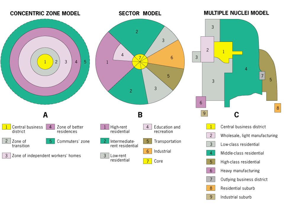
Models of urban structure: 3 social science model used to explain where people live in cities All 3 developed in the city of Chicago and later applied elsewhere: Concentric zone model (Burgess) Sector model (Hoyt) Multiple nuclei model
 Sector model (Hoyt) Multiple nuclei model.")
2
Inside the City: Competitive bidding for land determines much of the land use within the city In general, population density & land values decrease as distance from the CBD increases – Peak-value intersections Population densities tend to show a hollow center

3
Concentric zone model:
Theory represented the American city in a new stage of development Before the 1870s, cities such as New York had mixed neighborhoods where merchants’ stores and sweatshop factories were intermingled with mansions and hovels Rich and poor, immigrant and native-born, rubbed shoulders in the same neighborhoods. In Chicago, Burgess’s home town, the great fire of 1871 leveled the core Chicago became a segregated city with a concentric pattern The actual map of the residential area does not exactly match his simplified concentric zones

4
1- The Concentric Zone Model (Bugess Land Model
In the concentric zone model, a city grows in a series of rings surrounding the CBD, like the rings of a tree. The further from the CBD, the better the quality of housing “Invasion and succession”: refers to continued expansion of CBD and continual push outwards of zones

5
CBD: nonresidential activities concentrated
Transition zone: contains industry and poor quality housing. Immigrants to city first live here Working class homes: modest older homes - working class Zone of better residences: newer, more spacious homes Commuter’s Zone: beyond built-up area of the city

6
Zone 2 Characterized by mixed pattern of industrial and residential land use Rooming houses, small apartments, and tenements attract the lowest income segment Often includes slums and skid rows, many ethnic ghettos began here Usually called the transition zone

7
Zone 3 The “workingmen’s quarters” Solid blue-collar, located close to factories of zones 1 and 2 More stable than the transition zone around the CBD Often characterized by ethnic neighborhoods — blocks of immigrants who broke free from the ghettos Spreading outward because of pressure from transition zone and because blue-collar workers demanded better housing

8
-Zone 4 Middle class area of “better housing” Established city dwellers, many of whom moved outward with the first streetcar network Commute to work in the CBD Zone 5 Consists of higher-income families clustered together in older suburbs Located either on the farthest extension of the trolley or commuter railroad lines Spacious lots and large houses From here the rich pressed outward to avoid congestion and social heterogeneity caused by expansion of zone 4

9
Critics of the model: Pointed out even though portions of each zone did exist, rarely were they linked to totally surround the city Burgess countered there were distinct barriers, such as old industrial centers, preventing the completion of the arc Others felt Burgess, as a sociologist, overemphasized residential patterns and did not give proper credit to other land uses

10
Von Thunen Burgess 1. Central Business District 2. Zone of transition
Zone of independent workers zones 4. Zone of better residence 5. Commuters zone

11
Free Response 2008: Von Thunen’s model of land use and Burgess’ model of land use are similar in appearance but different in their geographic setting. Analyze and discuss the two models in terms of each of the following: A.) For each of these models, identify the type of land use the model addresses. B.) Identify two assumptions that are shared by both models. C.) For each of these models, explain how relative location affects land-use patterns
 For each of these models, identify the type of land use the model addresses. B.) Identify two assumptions that are shared by both models. C.) For each of these models, explain how relative location affects land-use patterns.")
12
2- The Sector Model In the sector model, a city grows in a series of wedges or corridors extending out from the CBD.

13
Economist Homer Hoyt (1939): city develops a series of sectors, not rings. Certain areas are more attractive for various activities As city grows, activities expand outward in a wedge, or sector, from the center Maintained high-rent districts were instrumental in shaping land-use structure of the city

14
Sector model: Hoyt suggested high-rent sector would expand according to four factors: Moves from its point of origin near the CBD, along established routes of travel, toward another nucleus of high-rent buildings Will progress toward high ground or along waterfronts, when these areas are not used for industry Will move along the route of fastest transportation Will move toward open space

15
Sector model: As high-rent sectors develop, areas between them are filled in: Middle-rent areas move directly next to them, drawing on their prestige Low-rent areas fill remaining areas Moving away from major routes of travel, rents go from high to low There are distinct patterns in today’s cities that echo Hoyt’s model He had the advantage of writing later than Burgess — in the age of the automobile

16
3- Multiple Nuclei Model
The multiple nuclei model views a city as a collection of individual centers, around which different people and activities cluster.

17
Some activates are attracted to particular nodes (e. g
Some activates are attracted to particular nodes (e.g. - a university may attracted well educated residents, bookstores, and pizzerias, whereas an airport may attract hotels and warehouses) Incompatible land-use activities will avoid clustering - such as heavy industry and high-class housing
 Incompatible land-use activities will avoid clustering - such as heavy industry and high-class housing.")
18
Edge Cities & the Urban Realm
Outer city, suburban downtowns, often located near key freeway intersections, often developed around regional shopping centers and industrial parks. Also can have: - office complexes - shopping centers - hotels - restaurants - Entertainment facilities sports complexes May approach 100,000 in population Examples include: Tysons Corner, Virginia and Irvine, California

20
Geographic Applications of the Models:
Concentric Zone: consider 2 families with the same income and ethnic background. 1 owns their home, the other rents. The owner is more likely to live in an outer ring and the renter in inner ring Sector Model: Given 2 families with their own homes, family with higher income will not live in same sector as lower income family Multiple Nuclei Model: People of same racial/ethic background likely to live near one another.

21
Application to Indianapolis
Percent of renters follows the concentric zone model. The percentage of households that rent their home is greater near the CBD and less in the outer rings of the city.

22
Application to Indianapolis
Median household income follows the sector model. Income is highest in a sector to the north, which extends beyond the city limits to the adjacent county.

23
Application to Indianapolis
Ethnic concentrations of minorities follows the multiple nuclei model. Ethnic groups are clustered in different areas.

24
Colonial Cities: Spanish (Latin America):
Conquistadores completely erased indigenous settlements and mingled with the local culture to become a part of it. Thus, Spanish colonial cities are more unitary in nature and follow Spanish elements. Laws of the Indies, 1573 Cities centered around church and central plaza Grid-iron street plan Administrative system is also more centralized than that of the Portuguese in Brazil.

25
Central Plaza of Mexico City

26
Colonial Cities: French and British
Never mingled with the local population and created separate quarters for themselves. Thus, French and British colonies usually have a "White Town" consisting of spacious houses, well laid out streets and a "Native Town" which were usually quite dense and housed the indigenous population. In apartheid countries of Africa, the division is very well defined. Most colonial cities were either coastal (to allow maritime trade with the colonies) or administrative.
 or administrative.")
27
Fez, Morocco (French = New Town)
")
28
Ho Chi Minh City, Vietnam (French demolished and rebuilt city)
")
29
Cities Since Independence:
Focal points of change In Latin America, wealthy push out from center in elite residential sector which develops along a spine (offices, shops, restaurants) Squatter settlements: area within a city in an LDC in which people illegally establish residences on land they do not own or rent and erect homemade structures
 Squatter settlements: area within a city in an LDC in which people illegally establish residences on land they do not own or rent and erect homemade structures.")
30
Modeling the Cities of the Global Periphery and Semiperiphery:
Latin America: Griffin-Ford Model (1980) showed the L.A. cities blend traditional elements of Latin American culture with forces of globalization that are reshaping the urban scene, combining radial sectors and concentric zones Disamenity sector: poorest parts of cities that are not connected to regular city services and typically controlled by gangs & drug lords
 showed the L.A. cities blend traditional elements of Latin American culture with forces of globalization that are reshaping the urban scene, combining radial sectors and concentric zones. Disamenity sector: poorest parts of cities that are not connected to regular city services and typically controlled by gangs & drug lords.")
31
African Immigrants in Paris
West African immigrants being removed from an apartment building in suburban Paris where they are accused of being squatters.

32
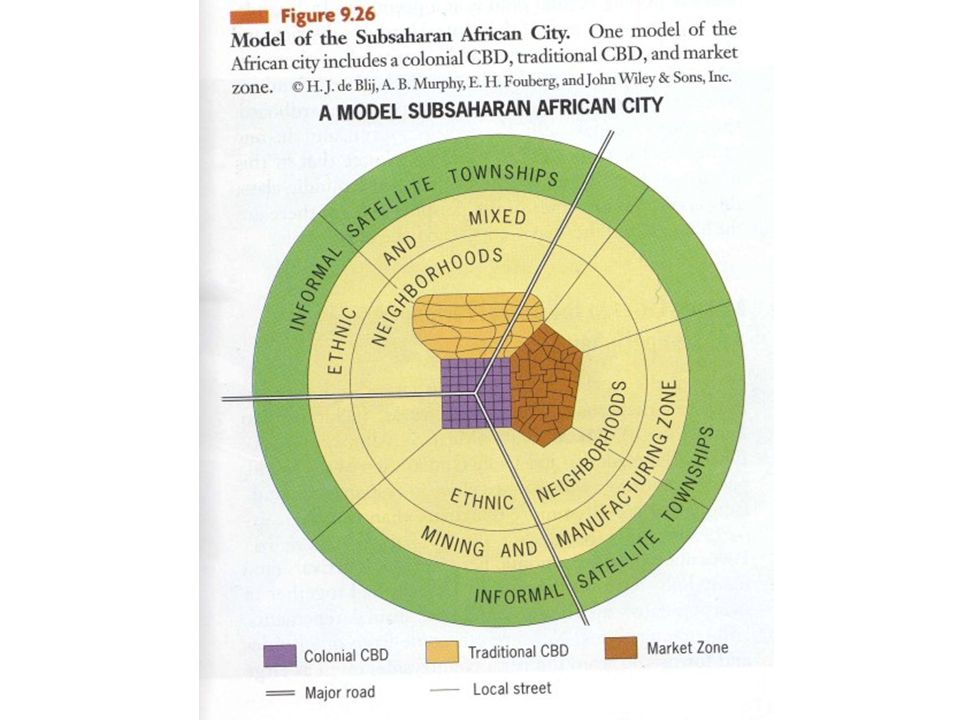
The African City: Difficult to formulate 1 model
At start of 20th century, Sub-Saharan Africa contained world lowest levels of urbanization Today has world’s fastest growing cities Imprint of colonialism - Europeans laid out prominent urban centers in western style (including high rise CBD’s and sprawling suburbs Central city typically contains 3 CBD’s - remnant of colonial CBD, an informal market zone, and a transitional business center

34
Nairobi, Kenya

35
Asian Cities: Located on coasts because built for trade
Ports are very important Special Economic Zones: Western companies locate here Provide jobs (Shanghai and Mumbai) Entrepots: cities that re-export goods that are brought into their borders, sending items to all areas of the globe Seoul, South Korea Singapore (city-state) Hong Kong, China
 Entrepots: cities that re-export goods that are brought into their borders, sending items to all areas of the globe. Seoul, South Korea. Singapore (city-state) Hong Kong, China.")
37
Southeast Asian City: Some of the most populous cities in world
McGee Model (1967): focal point of city is old colonial port zone combined with large commercial district which surrounds it. No formal CBD - government zone, alien commercial zone dominated by Chinese merchants, and mixed land-use zone Residential zones similar to Griffin-Ford Latin American model
: focal point of city is old colonial port zone combined with large commercial district which surrounds it. No formal CBD - government zone, alien commercial zone dominated by Chinese merchants, and mixed land-use zone. Residential zones similar to Griffin-Ford Latin American model.")
38
AC = Alien commercial and WC = western commercial

Similar presentations


 in 1939 Studied 64 widely distributed American cities Publication:>")


>")