Download presentation
Presentation is loading. Please wait.

1
Weather & Climate Grade 10 Geography

2
Weather and Climate Weather is the daily occurrence of wind, precipitation and temperature. Combination of temperature, precipitation, cloud coverage, relative humidity, wind and atmospheric pressure. Climate is the averages of weather conditions over a yearly or seasonal period of time.

3
Factors that affect climate and weather
Factors that affect climate and weather are: wind latitude elevation proximity to water (closeness to water) ocean currents aspect of the land (topography
 ocean currents. aspect of the land (topography.")
4
Prevailing Wind In Canada we experience Westerlies – the prevailing winds move air masses that affect our weather – from West to East. As air masses move over the Arctic in the winter, it will be cold & dry. As it moves southward, its cold dry conditions are carried across Canada. If an air mass comes from the Gulf of Mexico it brings moist, warm conditions to Canada.

5
Latitude The further you move away from the equator, in the north or south direction, the cooler it becomes. The sun’s energy is spread over a larger area the more you move away. Canada in relation to Central America

6
Elevation - Relief refers to the differences in elevation of the Earth’s surface. Mountain ranges act as barriers to the movement of air masses. Temperatures drop as you climb a mountain – as the elevation increases the temperature gets colder. Air expands as it rises since there is less air pressure.

7
Proximity to Water Oceans and large lakes heat up & cool down more slowly than land masses. In Summer – body of water remains cooler that then land – winds blowing off the water keep the surrounding land cooler. In Winter – bodies of water retain their heat & are warmer than the land. Winds blowing off the water keep the surrounding land warmer. Maritime climates therefore have cooler summers & milder winters.

8
Ocean Currents Temperature of an ocean current affect the temperature of air that passes over it. West Coast – the warm North pacific Current heats the cool moist air that passes over it = mild climate on the costal region of BC. East Coast – the cold Labrador Current, cools the air of coastal location in Labrador and Newfoundland.

9
Two types of climate: Maritime – near large bodies of water, experience considerable amounts of precipitation. Continental – seasonal precipitation and temperature.

10
Three types of precipitation:
Orographic precipitation (mountains) Frontal precipitation Convectional precipitation (circulation)
 Frontal precipitation. Convectional precipitation (circulation)")
11
Orographic precipitation
AKA Relief Precipitation Rain or snow that results when air is cooled as it is forced aloft by a topographic barrier such as a mountain. Common in British Columbia.

13
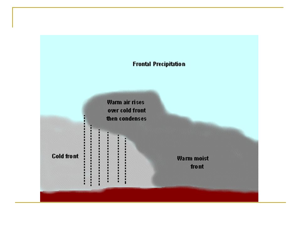
Frontal precipitation
Occurs when colder air mass forces a warmer air mass to rise. Common in Atlantic Canada.

15
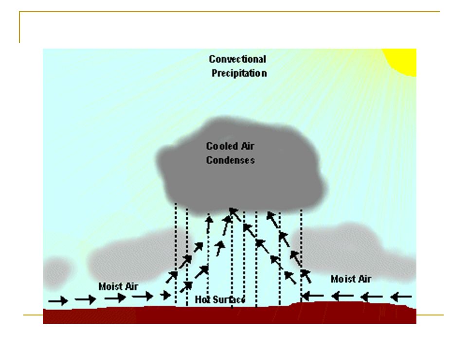
Convectional Precipitation
Heating of the earth's surface that causes air to rise rapidly. As the air rises, it cools and moisture condenses into clouds and precipitation. Common in the Prairie Provinces.

17
Cloud Formation As air rises it cools, as it cools the air particles condense and attach to dust particles. As moisture continues to develop, clouds are formed. Once the clouds reach the saturation point (the point where the clouds cannot hold anymore moisture) precipitation occurs.
 precipitation occurs.")
18
Hydrologic Cycle or Water Cycle
Saturation Point Clouds Form Precipitation Air cools and condenses (Condensation) Hot Air Rises (Evaporation) Water Land (Water Cycle) (Hydrologic Cycle)
 Hot Air Rises (Evaporation) Water. Land. (Water Cycle) (Hydrologic Cycle)")
19
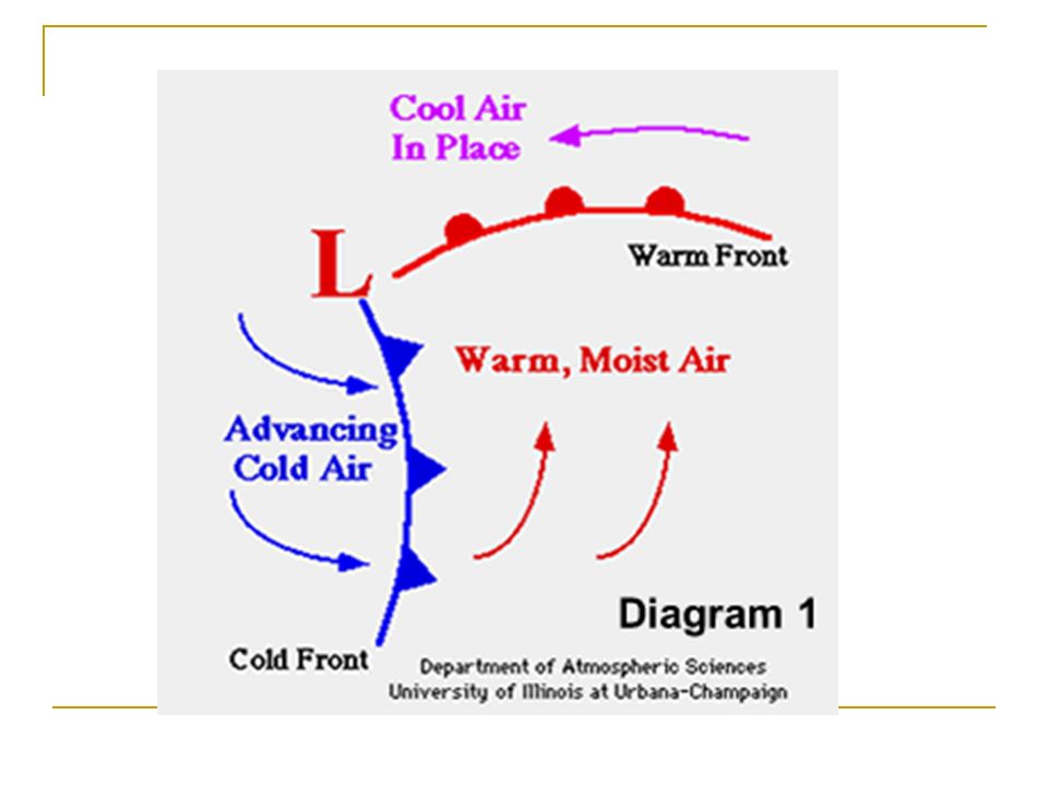
What Makes Weather? Front – where warm air and cold air meet.
Stationary Front – Warm air and cold air move in opposite directions where neither air mass is having any force on the other. W C

20
Warm Front – Warm air forces cold air out of the way. W C Cold Front – Cold air forces warm air out of the way. W C

21
“Iso” If “Iso” means the same, Then what are Isotherms? Isobar?
Isohyets? Isostatic rebound?

22
Isotherms = Places that have the same temperature.

23
Isobar = Places that have the same barometric pressure.

24
Isohyets = Places that have the same humidity.

25
Isostatic rebound = Places that have the same movement upward from the retreat of the glaciers.

26
Cloud Classification Stratos – (sheet-like) above 6000m
Cumulus – (pile) m Nimbus – (rain) – m Cirrus – (hairlike) – below 500m = fog Cumulonimbus – large dark storm clouds
 m. Nimbus – (rain) – m. Cirrus – (hairlike) – below 500m = fog. Cumulonimbus – large dark storm clouds.")
27
Barometric Pressure The amount of pressure the air is forcing down to the ground kPa (kilopascals) High pressure = sunny, clear skies Low pressure = cloudy, cooler temps & precipitation

28
Chinook Wind A Chinook Wind occurs when enough heat exists.
These warm winds often melt snow in the fields and forest on the lower slopes. Occurring near mountain ranges. Can raise temperatures as much as 20°C to 30°C in a 24 hour period, and melt the shallow snow. Calgary experiences Chinooks.

29
High vs Low Pressure Belts
The air is warm at the equator and rises, which forms a belt of low pressure around the earth. If it wasn't for the earth's rotation and the Coriolis force, that air would then sink at the poles and form two high pressure zones. But it falls at roughly latitudes 30 N and 30 S. Those are two belts of low pressure. Between those and the polar ones, a front exists along which warmer air rises over colder one. That creates then two belts of high pressure at roughly the latitudes 60 N and 60 S.

30
Hadley Cell The circulation between the equator and the high pressure belts.

31
Trade winds Also called trades.
Surface winds found in the tropics within the lower portion of the Earth's atmosphere.

32
Doldrums A band of air encircling the Earth just north of the equator.
Where winds from the northern and southern hemispheres meet.

33
Low pressure system Cloudy or stormy weather
Barometric pressure is lowered and a low-pressure system forms, it brings in air, usually from a cold front to the north. A strong low-pressure system in winter may bring snow and ice to the areas it covers. Tornadoes, have low air pressure inside their funnels. Low pressure system over water can lead to a Hurricane.

Similar presentations