Download presentation
Presentation is loading. Please wait.

1
Unit 1 Geography Basics

2
Geography – the study of the earth and the ways people live and work on it; including the distribution and interaction of physical and human features

3
5 Themes of Geography 1) Location – refers to where it is There are 2 types of location (absolute and relative) Absolute Location is the precise location on the globe The globe can be split into hemispheres Absolute location is found using longitude and latitude The equator and tropics are latitude lines; the prime meridian is a longitude line Relative Location is where something is in relation to something else
 Location – refers to where it is There are 2 types of location (absolute and relative) Absolute Location is the precise location on the globe The globe can be split into hemispheres Absolute location is found using longitude and latitude The equator and tropics are latitude lines; the prime meridian is a longitude line Relative Location is where something is in relation to something else")
4
2) Place – refers to what it is like there Place includes physical features (natural and man made) and cultural features (language, religion, beliefs, etc.)
 Place – refers to what it is like there Place includes physical features (natural and man made) and cultural features (language, religion, beliefs, etc.)")
5
3) Region – refers to how areas are similar and different Areas with similar characteristics (plant, animal, governments, languages, and religions) are grouped together
 Region – refers to how areas are similar and different Areas with similar characteristics (plant, animal, governments, languages, and religions) are grouped together")
6
4) Human and Environment Interaction - refers to how people relate to the physical world People use what is given to them, and change and adapt to the environment to meet their needs This also includes negative aspects such as pollution
 Human and Environment Interaction - refers to how people relate to the physical world People use what is given to them, and change and adapt to the environment to meet their needs This also includes negative aspects such as pollution")
7
5) Movement – refers to how people, ideas, and products move from one place to another Includes migration, immigration, automobiles, T.V., radio, internet, and cell phones
 Movement – refers to how people, ideas, and products move from one place to another Includes migration, immigration, automobiles, T.V., radio, internet, and cell phones")
8
Geographer’s Tools Geographer’s tools include globes and maps Geographers also use GPS (Global Positioning Systems) and GIS (Geographic Information Systems { a database})
 and GIS (Geographic Information Systems { a database})")
9
Types of maps Physical Maps – these maps show topography (physical features) and relief (difference in elevation)
 and relief (difference in elevation)")
10
Political Maps – these maps show political boundaries

11
Thematic Maps – these are maps used for a specific purpose

12
Map Projections These are ways of presenting a round earth on a flat surface All map projections are distorted

13
Mercator projection – used for sea travel; it gives true direction

14
Polar projection- used for air travel; it shows the shortest distance between points

15
Robinson projection – shows true size and shape

16
The Earth

17
Bodies of Water Oceans, Seas, Lakes, Rivers, Ground Water Hydrologic (Water) Cycle
 Cycle")
18
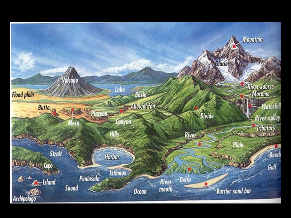
Landforms Continent, Mountains, Hills Plateau – relatively flat area which is higher than the surrounding area Valleys and Canyons Peninsula – extension of the continent with water on 3 sides Isthmus- narrow strip of land connecting 2 large landmasses Archipelago – group of islands Continental Shelf

20
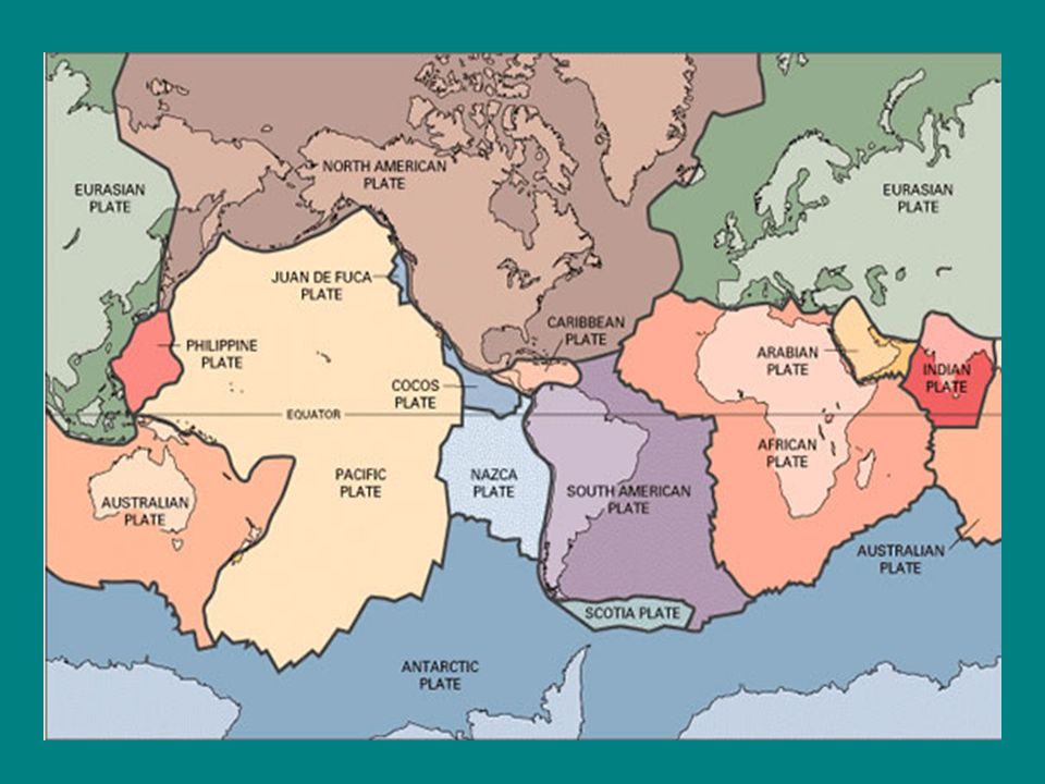
Internal Forces that shape the Earth Plate Tectonics The study of the movement of pieces of the earth’s crust (tectonic plates) The earth’s plates move all the time When 2 plates meet they can create folds (mountains) or faults
 The earth’s plates move all the time When 2 plates meet they can create folds (mountains) or faults")
22
Earthquakes These are caused when plates grind on one another Earthquakes are measured by a seismograph; the strength is recorded on the Richter Scale An underwater quake can cause tsunami’s (giant waves)
")
23
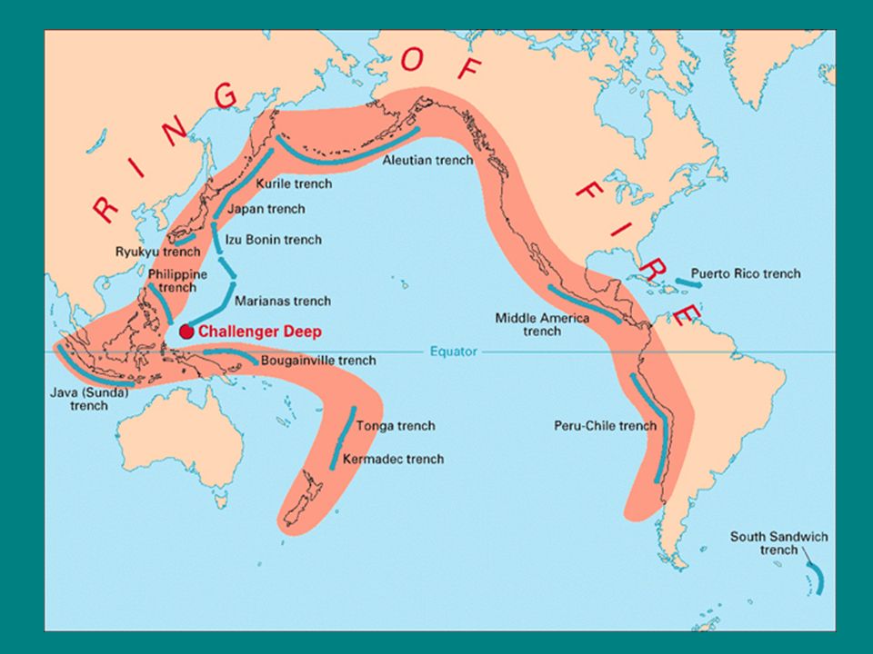
Volcanoes The flowing of magma onto the earth’s surface through cracks in the crust Volcanic ash produces rich, fertile soil Hot springs and geysers are included in this category Ring of Fire refers to a zone in the Pacific where 8 plates meet; it contains the most volcanoes in the world

25
External Forces that shape the Earth Weathering – physical and chemical changes to the characteristics of rocks This process creates sediment Weathering can be mechanical or chemical Mechanical weathering changes the size of the rock (physical) Chemical weathering changes rock into a new substance Erosion – the movement of weathered material by wind, water, ice(glacier) and gravity
 Chemical weathering changes rock into a new substance Erosion – the movement of weathered material by wind, water, ice(glacier) and gravity")
26
Seasons Seasons happen as a result of the earth’s tilt and rotation around the sun Equinoxes are when the sun is in line with the equator (Spring and Fall) Solstices are when the sun is over the tropics (Summer and Winter) The seasons can help determine weather and climate
 Solstices are when the sun is over the tropics (Summer and Winter) The seasons can help determine weather and climate")
27
Weather Weather is the condition of the atmosphere at a particular place and time Weather is determined by precipitation, elevation, and air movement Extreme weather includes hurricanes, typhoons, and cyclones (same type of storm different locations) Extreme weather also includes tornadoes, blizzards, droughts, and monsoons (seasonal wind)
 Extreme weather also includes tornadoes, blizzards, droughts, and monsoons (seasonal wind)")
28
Climate Climate is the weather conditions at a location over a period of time Factors that affect climate 1)Wind- the movement of heat from cold to hot areas - hot air moves from the poles, cold air moves to the equator - wind blows at angles because of the earth’s rotation Types of Wind - trade winds (wind in the low latitudes) - easterlies (wind in the high latitudes) - westerlies (wind in the mid latitudes)
Wind- the movement of heat from cold to hot areas - hot air moves from the poles, cold air moves to the equator - wind blows at angles because of the earth’s rotation Types of Wind - trade winds (wind in the low latitudes) - easterlies (wind in the high latitudes) - westerlies (wind in the mid latitudes)")
29
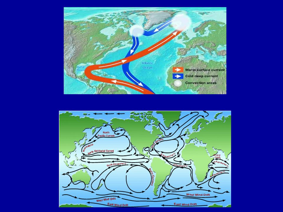
2) Ocean Currents – water running through to ocean is hot and cold - water moves from hot areas to cold areas - in combination with the wind they can cool or heat the land
 Ocean Currents – water running through to ocean is hot and cold - water moves from hot areas to cold areas - in combination with the wind they can cool or heat the land")
32
3) Latitude – weather and climate are determined by it location on the globe - Low Latitudes – areas between the tropics that receive sun all year creating warm climates - Middle Latitudes – areas from the tropics to the circles - the rotation of the earth creates changing seasons - High Latitudes – areas from the circles to the poles; these areas go through rotations of dark and sunlight
 Latitude – weather and climate are determined by it location on the globe - Low Latitudes – areas between the tropics that receive sun all year creating warm climates - Middle Latitudes – areas from the tropics to the circles - the rotation of the earth creates changing seasons - High Latitudes – areas from the circles to the poles; these areas go through rotations of dark and sunlight")
33
4) Elevation – weather and climate changes as you go up in elevation 5) Topography - landforms can affect the movement of wind and water systems
 Elevation – weather and climate changes as you go up in elevation 5) Topography - landforms can affect the movement of wind and water systems")
34
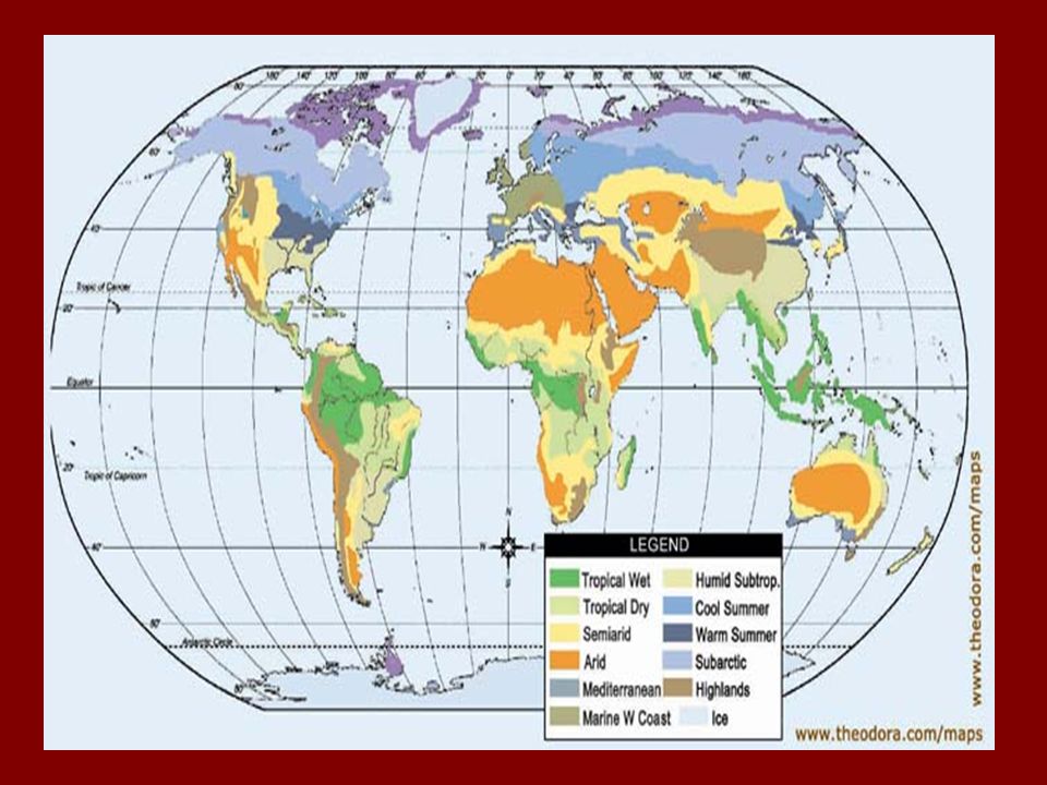
Climate Zones These zones include tropical wet and dry, tropical wet, desert (arid), semi-arid, Mediterranean, and marine west coast The Climate Zones that most affect us are: 1)Humid Subtropical – long periods of summer with mild winters; usually on the SE coastal regions of continents 2)Humid Continental – 4 distinct seasons with varying temperatures and precipitation (mid-latitudes in the US) 3)Highland – changes in climate based on elevation
, semi-arid, Mediterranean, and marine west coast The Climate Zones that most affect us are: 1)Humid Subtropical – long periods of summer with mild winters; usually on the SE coastal regions of continents 2)Humid Continental – 4 distinct seasons with varying temperatures and precipitation (mid-latitudes in the US) 3)Highland – changes in climate based on elevation")
36
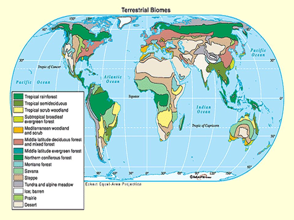
Vegetation The vegetation of a region helps to sustain life through agriculture, livestock and timber Forests include deciduous, rain forests and coniferous Grasslands include savanna (tropical) and steppe or prairie (temperate) Desert and Tundra has little to no vegetation; deserts tend to be hot, tundra cold
 and steppe or prairie (temperate) Desert and Tundra has little to no vegetation; deserts tend to be hot, tundra cold")
38
Culture The ways of life of a group of people with common traditions, interests and beliefs Culture includes history, government, language, religion, art, music, education and the economy Society is a group of people who share a geographic region Ethnic group is a group of people who share language, customs and heritage Culture begins at a cultural hearth, which is the center from where ideas, materials and technology are spread (diffused)
")
39
Languages are used to establish identity (3,000 – 6,500 languages worldwide) Each language may include different dialects Religion There are 3 categories of religion; monotheistic, polytheistic, and animistic
 Each language may include different dialects Religion There are 3 categories of religion; monotheistic, polytheistic, and animistic")
40
Types of Religions Judaism – based on the belief in the word of God Followed by the Hebrews or Jewish people The holy book is the Torah Christianity – based on the teachings of Jesus; Son of God Added the New Testament to the Bible Largest of all faiths worldwide Islam - based on the teachings of the prophet Muhammad Followers are called Muslims and worship Allah (God) The holy book is the Quran (Koran) It is related to Judaism and Christianity
 The holy book is the Quran (Koran) It is related to Judaism and Christianity")
41
Hinduism- polytheistic religion with respect to the divine spirit - requires a caste system with fixed social classes to fulfill specific jobs Buddhism- based on Hinduism without the caste system - live your life correctly until you reach nirvana - believe in reincarnation

42
Political Geography State – one unit occupying territory and controlling all affairs (country) Nation – a group of people with common culture living together Nation- state – nation and state in the same territory
 Nation – a group of people with common culture living together Nation- state – nation and state in the same territory")
43
Types of GovernmentTypes of Government Democracy – citizens hold the power Monarchy – a King or Queen hold power or may share that power (United Kingdom) Dictatorship – individual or group holds all of the power Communism – government and economy where political power is held by the government in the name of the people
 Dictatorship – individual or group holds all of the power Communism – government and economy where political power is held by the government in the name of the people")
44
Economic Geography This explores the impact of the economy on a society Economic activities can include agriculture and industry Most nation’s economic wealth can be determined by its resources Natural resources are changed to resources depending on need Natural resources include renewable and non renewable

45
Types of Economic Systems 1) Command Economy- this is an economy where the production of goods and services are determined by the government; the government owns the businesses 2) Market Economy (Demand Economy) – this is an economic system where the production of goods and services are determined by the people; businesses are privately owned
 Command Economy- this is an economy where the production of goods and services are determined by the government; the government owns the businesses 2) Market Economy (Demand Economy) – this is an economic system where the production of goods and services are determined by the people; businesses are privately owned")
46
Terms to measure the economy Per capita income – average money made by a person GNP(Gross National Product) – the total value of goods over time GDP(Gross Domestic Product)- the total value of goods within a country over time
 – the total value of goods over time GDP(Gross Domestic Product)- the total value of goods within a country over time")
47
Developed Nations- these are nations that are industrialized and have good access to technology Developing Nations- these are nations in the process of industrializing and have limited access to technology

Similar presentations


 Which is closest to the equator?>")


