Download presentation
Presentation is loading. Please wait.

1
3D Mineral Mapping of the Rocklea Dome Channel Iron Ore Deposit
Maarten Haest1, Tom Cudahy1, Carsten Laukamp1, Sean Gregory2 1Western Australian Centre of Excellence for 3D Mineral Mapping (C3DMM), CESRE 2Murchison Metals Ltd.
, CESRE. 2Murchison Metals Ltd.")
2
Interpretation of visible-near to shortwave infrared reflectance drill core data from a channel iron deposit in the Hamersley Province (WA) Channel iron deposits (CID) 2nd most important source for Fe production in WA CIDs developed along Tertiary paleochannels Fe-(oxyhydr-)oxide pelletoids and ferruginised wood fragments, cemented in goethite matrix Rare detrital components (e.g. qtz, BIF fragments or clays) Many pelletoids are ooids, with hematite or goethite core and goethite shells Morris et al. (1993) One major step to achieving this vision is the generation of an ASTER satellite geoscience map of Australia (~18 products), which provides mineral group information of value for mapping the regolith, primary geology as well as superimposed metamorphic and metasomatic alteration affects. This involves ~4000 ASTER multi‐spectral (14 bands) scenes collected between 2000 and 2008 provided by NASA/ERSDAC/USGS. Specific applications of these maps include: (1) more accurate mapping of transported versus in situ materials to improve drill hole planning; (2) recognition of mineral vectors to ore systems; and (3) baseline environmental mapping prior to resource development. Ramanaidou et al. (2003)
 2nd most important source for Fe production in WA. CIDs developed along Tertiary paleochannels. Fe-(oxyhydr-)oxide pelletoids and ferruginised wood fragments, cemented in goethite matrix. Rare detrital components (e.g. qtz, BIF fragments or clays) Many pelletoids are ooids, with hematite or goethite core and goethite shells. Morris et al. (1993) One major step to achieving this vision is the generation of an ASTER satellite geoscience map of Australia (~18. products), which provides mineral group information of value for mapping the regolith, primary geology as well. as superimposed metamorphic and metasomatic alteration affects. This involves ~4000 ASTER multi‐spectral. (14 bands) scenes collected between 2000 and 2008 provided by NASA/ERSDAC/USGS. Specific applications of. these maps include: (1) more accurate mapping of transported versus in situ materials to improve drill hole. planning; (2) recognition of mineral vectors to ore systems; and (3) baseline environmental mapping prior to. resource development. Ramanaidou et al. (2003)")
3
Interpretation of visible-near to shortwave infrared reflectance drill core data from a channel iron deposit in the Hamersley Province (WA) internal variations of ore types in CID (pure endmember forms in figure to the right): Vitreous goethite often ass. with silica wide CFA above 900nm steep reflectance slope between and 1800nm Ochreous goethite powdery, strong yellow colour often ass. with Al-clays “Original” CID usually goethite (hematite) pelletoids, mixed with ferruginised wood fragments in goethite matrix One major step to achieving this vision is the generation of an ASTER satellite geoscience map of Australia (~18 products), which provides mineral group information of value for mapping the regolith, primary geology as well as superimposed metamorphic and metasomatic alteration affects. This involves ~4000 ASTER multi‐spectral (14 bands) scenes collected between 2000 and 2008 provided by NASA/ERSDAC/USGS. Specific applications of these maps include: (1) more accurate mapping of transported versus in situ materials to improve drill hole planning; (2) recognition of mineral vectors to ore systems; and (3) baseline environmental mapping prior to resource development. from Maarten Haest
: Vitreous goethite. often ass. with silica. wide CFA above 900nm. steep reflectance slope between 1400 and 1800nm. Ochreous goethite. powdery, strong yellow colour. often ass. with Al-clays. Original CID. usually goethite (hematite) pelletoids, mixed with ferruginised wood fragments in goethite matrix. One major step to achieving this vision is the generation of an ASTER satellite geoscience map of Australia (~18. products), which provides mineral group information of value for mapping the regolith, primary geology as well. as superimposed metamorphic and metasomatic alteration affects. This involves ~4000 ASTER multi‐spectral. (14 bands) scenes collected between 2000 and 2008 provided by NASA/ERSDAC/USGS. Specific applications of. these maps include: (1) more accurate mapping of transported versus in situ materials to improve drill hole. planning; (2) recognition of mineral vectors to ore systems; and (3) baseline environmental mapping prior to. resource development. from Maarten Haest.")
4
Rocklea Dome CID ASTER Airborne hyperspectral 14DD hylogged
~150 RC hylogged iron oxide (B4/B3) low high One major step to achieving this vision is the generation of an ASTER satellite geoscience map of Australia (~18 products), which provides mineral group information of value for mapping the regolith, primary geology as well as superimposed metamorphic and metasomatic alteration affects. This involves ~4000 ASTER multi‐spectral (14 bands) scenes collected between 2000 and 2008 provided by NASA/ERSDAC/USGS. Specific applications of these maps include: (1) more accurate mapping of transported versus in situ materials to improve drill hole planning; (2) recognition of mineral vectors to ore systems; and (3) baseline environmental mapping prior to resource development.
 low. high. One major step to achieving this vision is the generation of an ASTER satellite geoscience map of Australia (~18. products), which provides mineral group information of value for mapping the regolith, primary geology as well. as superimposed metamorphic and metasomatic alteration affects. This involves ~4000 ASTER multi‐spectral. (14 bands) scenes collected between 2000 and 2008 provided by NASA/ERSDAC/USGS. Specific applications of. these maps include: (1) more accurate mapping of transported versus in situ materials to improve drill hole. planning; (2) recognition of mineral vectors to ore systems; and (3) baseline environmental mapping prior to. resource development.")
5
Rocklea Dome CID Channel iron ore iron oxide

6
: RC cores with XRF : RC cores with XRF + HyLogging Haest et al. (2012a, b)
")
8
“hyperspectral” Fe3+ content – Rocklea Dome data
RMSE: 9.1 wt% Fe XRF Fe2O3 content HyLogger 900 nm absorption depth (900D – fitted 2nd order polynomial nm) SiO2 wt% XRF Haest et al. (2012a, b)
 SiO2 wt% XRF. Haest et al. (2012a, b)")
9
Iron ore resource delineation
Haest et al. (2012a, b)
")
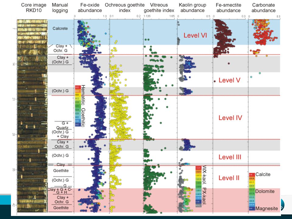
10
Iron ore type characterisation
Ochreous goethite: soft and powdery Vitreous goethite: hard and shiny

11
Clay type characterisation
Haest et al. (2012a, b)
")
12
Kaolin crystallinity (airborne+drillcore) Height exaggeration: 12*
modelled CID resource modelled base of channel

13
Conclusions – Rocklea Dome
Quantitative mineralogy from surface and subsurface infrared spectroscopic data, when processed in 3D provide Rapid iron ore resource delineation Iron ore type characterisation processing Clay mineralogy geotechnical purposes Clay composition guide to CID exploration potential Airborne hyperspectral (and satellite multispectral data) can be used for CID exploration and characterisation Same routines are being applied to diamond and rock chip drill cores from BHP Billiton’s BID and CID deposits in the Hamersley Range and to many other commodity types across Australia
 can be used for CID exploration and characterisation. Same routines are being applied to diamond and rock chip drill cores from BHP Billiton’s BID and CID deposits in the Hamersley Range and to many other commodity types across Australia.")
14
Further Reading Cudahy, T.J., and Ramanaidou, E.R., 1997, Measurement of the hematite: goethite ratio using field visible and near-infrared reflectance spectrometry in channel iron deposits, Western Australia: Australian Journal of Earth Sciences, v. 44, p. 411−420. Haest, M., Cudahy, C., Rodger, A., Laukamp, C., Martens, C., Caccetta, M. (2013): Unmixing vegetation from airborne visible-near to shortwave infrared spectroscopy-based mineral maps over the Rocklea Dome (Western Australia), with a focus on iron rich palaeochannels.- Remote Sensing of Environment, 129, Haest, M., Cudahy, T., Laukamp, C., Gregrory, S. (2012): Quantitative mineralogy from visible to shortwave infrared spectroscopic data - I. Validation of mineral abundance and composition products of the Rocklea Dome channel iron deposit in Western Australia.- Economic Geology, 107, Haest, M., Cudahy, T., Laukamp, C., Gregrory, S. (2012): Quantitative mineralogy from visible to shortwave infrared spectroscopic data - II. 3D mineralogical characterisation of the Rocklea Dome channel iron deposit, Western Australia - Economic Geology, 107, Ramanaidou, E.R., Morris, R.C., and Horwitz, R.C., 2003, Channel iron deposits of the Hamersley Province, Western Australia: Australian Journal of Earth Sciences, v. 50, p. 669−690.
: Unmixing vegetation from airborne visible-near to shortwave infrared spectroscopy-based mineral maps over the Rocklea Dome (Western Australia), with a focus on iron rich palaeochannels.- Remote Sensing of Environment, 129, Haest, M., Cudahy, T., Laukamp, C., Gregrory, S. (2012): Quantitative mineralogy from visible to shortwave infrared spectroscopic data - I. Validation of mineral abundance and composition products of the Rocklea Dome channel iron deposit in Western Australia.- Economic Geology, 107, Haest, M., Cudahy, T., Laukamp, C., Gregrory, S. (2012): Quantitative mineralogy from visible to shortwave infrared spectroscopic data - II. 3D mineralogical characterisation of the Rocklea Dome channel iron deposit, Western Australia - Economic Geology, 107, Ramanaidou, E.R., Morris, R.C., and Horwitz, R.C., 2003, Channel iron deposits of the Hamersley Province, Western Australia: Australian Journal of Earth Sciences, v. 50, p. 669−690.")
15
Thank you CSIRO Earth Science and Resource Engineering
Carsten Laukamp Geoscientist t e w Western Australian Centre of Excellence for 3D Mineral Mapping/ MDU Flagship

Similar presentations


>")
 of snow surfaces at Dome C, Antarctica, for the inter-calibration and validation of satellite remote sensing products.>")


