Download presentation
Presentation is loading. Please wait.

1
The Nile River Chapter 5, Lesson 1

2
The Nile River While Mesopotamia had civilizations rise and fall, two other Civilizations flourished in northeastern Africa. Egypt in the northern part of the Nile River valley. Kush in the Southern part of the Nile River valley. Each culture was unique but they did influence each other throughout their long history.

4
Valley Civilization The Nile River valley was ideal for human settlement because it had fertile land. As early as 5000 B.C., Hunter-Gatherer groups from dry places in Africa and Southwest Asia began to move there. The settlements were permanent villages and farmed along the Nile River banks. These people were the earliest Egyptians and Kushites.

5
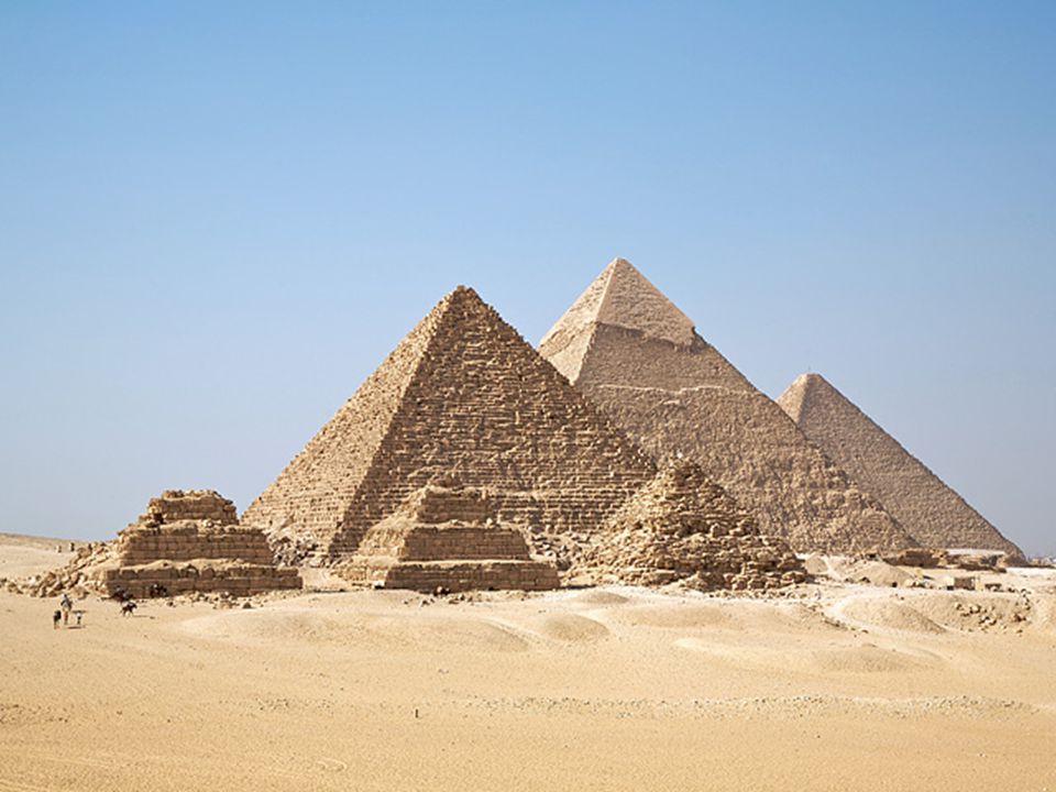
Valley Civilization The Egyptians in the northern region of the Nile River valley called their land Kemet (“black land”). Named so because of its dark, rich soil. It will eventually be renamed Egypt. Most are most familiar with Egypt and still marvel at its remains today. The remains include Pyramids, The Sphinx, and Mummies who were buried in tombs with riches.

9
Valley Civilization These structures survived this long because Egypt has a hot and dry climate. Egypt received very little rainfall. Relied on the Nile River for bathing and drinking. The river was also necessary for growing crops. Egyptians believed that the Nile was the “creator of all good.” It is the world’s longest river flowing 4,000 miles from Central Africa to the Mediterranean Sea. It is sometimes referred to as the “lifeblood” of Egypt.

10
Valley Civilization At the source, the Nile is two separate rivers.
The Blue Nile – Begins in the snowy mountain of Africa. The White Nile – Begins in the tropics of central Africa. The two rivers join south of Egypt and become one. At that location are steep cliffs and boulders. It forms cataracts (fast-moving waters) which make traveling by ship difficult.
 which make traveling by ship difficult.")
11
A Protected Land As with many rivers, the Nile’s flow throughout the centuries carved out a valley. Shortly before the Nile reaches the Mediterranean Sea it splits into many braches. They are marshlands called a delta.

12
A Protected Land The Nile Valley and delta also contrast strongly to the barren deserts on either side of the river. The change can be so sudden that you can have one foot on fertile soil and the other in barren sand. The Nile borders the largest deserts in the world. To the west is the Libyan desert, part of the Sahara. To the east is the Eastern desert that extends to the Red Sea. Called these deserts the Red Land because of their scorching heat. It was not favorable to humans or animals but it did keep Egypt isolated from outside invaders

13
A Protected Land Other physical features protected Egypt as well.
The south had the cataracts, which prevented enemy ships from sailing into the Nile. The North had the delta marshes which prevented invaders who sailed from the Mediterranean Sea. These features gave Egypt an advantage the Mesopotamians did not have. As a result they developed peacefully. They weren’t completely cut off though. Trader routes existed through the Mediterranean and Red Sea. They took advantage of the region’s wind pattern so they could travel and trade. River flowed naturally north but the wind could push sailboats south.

15
People of the River The Egyptians did not face the same flooding issues as Mesopotamia. The flooding was seasonal and consistent from year to year and did not give them any challenge.

16
Predictable Floods These floods typically happen in late springs.
Heavy tropical rains in central Africa and melting snow in eastern Africa added water to the Nile. The Egyptians took advantage of this because after the water returned to its normal level, the banks were filled with fertile soil.

17
How did Egyptians Farm? They planted wheat, barley, and flax seeds while the soil was still wet. This led to them having enough food for themselves and the animals they raised. During dry seasons, they used irrigation. Scooped out basins (bowl-shaped holes) to store river water and then used canals into the fields.
 to store river water and then used canals into the fields.")
18
How did Egyptians Farm? They eventually developed new tools to make farming easier. Shadoof – A bucket attached to a pole that lifts water from the Nile and empties into a basin. It is still used today. When the floods would wash away boundary markers, Egyptians used geometry to recalculate where one field ended and another began. Egyptians gathered papyrus (a reed plant that grew wild along the Nile). Used to weave rope, sandals, baskets, and river rafts. Later used to make paper by soaking them in water and pounding them together and set out to dry and eventually could be written on.
. Used to weave rope, sandals, baskets, and river rafts. Later used to make paper by soaking them in water and pounding them together and set out to dry and eventually could be written on.")
19
How did the Egyptians Write?
Like Mesopotamia, they developed their own writing system. It was made up of thousands of pictures symbols that represented objects and ideas. For example, a house may be represented as a house. Later they created symbols that represented sounds, similar to our alphabet. This combination of pictures and sounds were known as hieroglyphics.

20
How did the Egyptians Write?
Few ancient Egyptians knew to read or write hieroglyphics. Some men went to special schools to learn to prepare a career as a scribe. They did not write on clay tablets and instead used a special script that they wrote or painted on papyrus. They were also the ones to carve hieroglyphs on walls and monuments.

24
Uniting Egypt Since Egypt was protected they were able to grow surpluses (extra amounts) of food. Surplus would work on other occupations. Artisans, Merchants and Traders began to play an important role in Egypt’s Economy. Soon it would lead to trading with Nubia to the south, Mesopotamia to the northeast, and other places bordering Egypt. As they traded they learned about ways of life and governments of other societies.

25
Forming Kingdoms The need for organized government became increasingly important as farming and trade increased. Government was necessary to oversee the construction and repair of irrigation ditches and dams. It was also needed to develop and distribute grain during famines. They also settled disputes over land ownership.

26
Forming Kingdoms Soon, groups of villages would merge to become small kingdoms. Weaker kingdoms eventually taken over and controlled by stronger ones. By 4,000 B.C. Egypt was made up of two large kingdoms. Upper Egypt – Located in the south central part of the Nile River valley. Lower Egypt – Located along the Nile River’s north delta.

27
Who Was Narmer? Narmer was the king of Upper Egypt.
Led an army and conquered Lower Egypt around 3100 BC. He married one of Lower Egypt’s princesses, which unified the kingdoms and made Egypt ruled by one ruler together for the first time. He established a new capital in Memphis, a city that bordered both Upper and Lower Egypt, and governed both from their Memphis began to flourish as a center of government and culture along the Nile.

28
Who Was Narmer? His Kingdom lasted long after his death.
The right to rule was past along to son and then, grandson. This is known as a dynasty. When one dynasty dies out another takes its place. From 3100 B.C. to 322 B.C, 30 dynasties ruled Egypt. These dynasties are organized into three time periods: Old Kingdom, Middle Kingdom, and the New Kingdom. Throughout these three periods Egypt was usually united under a single ruler and enjoyed a stable government.

Similar presentations


 Cooking Cleaning.>")
