Download presentation
Presentation is loading. Please wait.

1
South Asia Physical Geography

2
On the Ganges River What are these women doing? Why are they doing it? Why are they doing it here, rather than at home?

3
Guiding Question What physical features make South Asia unique?

4
Main Ideas South Asia is made up of seven countries: India, Pakistan, Nepal, Bhutan, Bangladesh, Maldives and Sri Lanka Three mountain ranges make up the northern border of the region: Hindu Kush, Karakorum and Himalayas Three major rivers flood each year, providing rich farming soil: Indus, Ganges, Brahmaputra

8
Reading Progress Check Describe the main physical regions of South Asia

9
Mount Everest

10
Most climbers try to climb Mount Everest in April or May. During the winter, the temperatures are too cold and the winds are almost at hurricane force (70 mph). Climbing between June and September can be done, but it is difficult because monsoon conditions cause violent storms and heavy rains.
. Climbing between June and September can be done, but it is difficult because monsoon conditions cause violent storms and heavy rains..")
11
At over 29,000 feet above sea level, Mount Everest is the highest mountain in the world. Its peak is at about the same altitude that many commercial airplanes fly. Because it is so high, climbers must bring oxygen tanks and canisters to help them breathe.

12
Climbers of Mount Everest have left water bottles and oxygen canisters on the mountain, but human waste, discarded batteries, and fuel containers pose the biggest environmental problems.

13
Guiding Question How does climate affect people’s lives in South Asia?

14
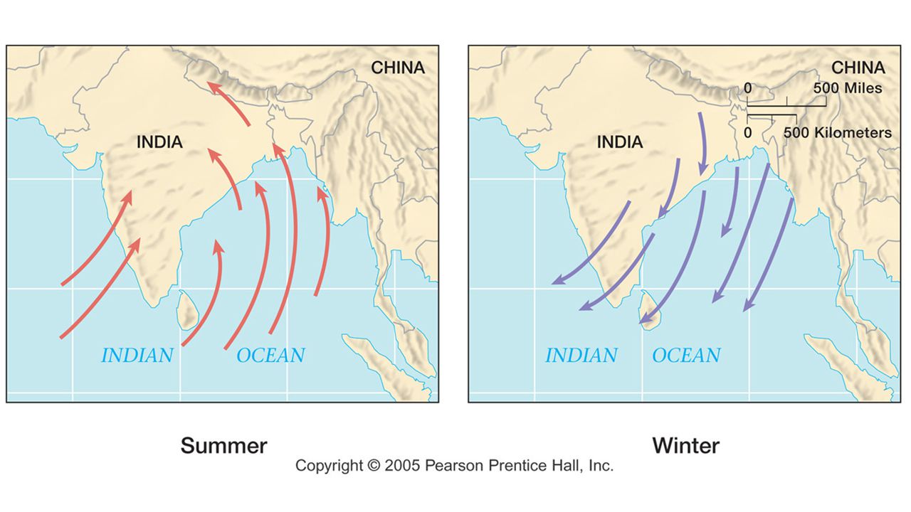
Main Ideas South Asia’s climate is a result of seasonal wind patterns called monsoons. Most of South Asia has a tropical wet/dry climate with three seasons. The mountain ranges are covered with snow year round and affect the climates of nearby areas at lower elevations.

15
Weather Extremes in South Asia Climate in South Asia often shifts from one extreme to another. For about eight months of the year, South Asia experiences drought (extremely dry weather) Beginning in May and early June, temperatures in the region rise, bringing moist air in from the oceans. These monsoon winds causes heavy rains and flooding.
 Beginning in May and early June, temperatures in the region rise, bringing moist air in from the oceans. These monsoon winds causes heavy rains and flooding..")
17
Reading Progress Check What positive and negative effects do monsoons have on the lives of people in South Asia?

18
Adaptations to the Environment For each of the following statements, decide whether the effect is caused by Hot or cold temperatures Dry, rainy or snowy weather Statements can have more than one response

19
Hot or Cold? Dry, Rainy or Snowy? Wear padded clothing or clothing made from wool? Cold, rainy and snowy Wear light colored, cotton clothing Hot and dry Houses have light colored roofs to reflect the sun’s heat Hot and dry Houses are made of sun-dried bricks Hot and dry

20
Hot or Cold? Dry, Rainy or Snowy? Houses are well-insulated with a furnace Cold, rainy and snowy Houses are built on pilings to protect from permafrost Cold and snowy Houses have steep, pointed roofs for run-off Rainy and snowy Rivers often substitute for roads that are difficult to build and maintain because of thick vegetation Hot and rainy

21
Hot or Cold? Dry, Rainy or Snowy? Special transportation is needed to cross the frozen landscape Cold and snowy Embankments are built to hold back river waters Rainy

22
Guiding Question Which natural resources are most important to South Asia’s large population?

23
Main Ideas South Asia has many resources that are evenly distributed throughout the region. India has most of South Asia’s mineral resources. There is controversy in South Asia about how to use water to provide energy. South Asia has important oil reserves. South Asia has forests that contain valuable varieties of timber.

24
Reading Progress Check Think about how people use rivers in South Asia. How is this similar to how people use rivers in other parts of the world?

25
Groundwater is fresh water that lies beneath the earth’s surface. It comes from rain and melted snow that pass through the soil. It also comes from water that seeps into the ground from lakes and rivers. Groundwater is continually recharged (refilled) with water that comes from the surface. Aquifer
 with water that comes from the surface. Aquifer.")
26
An aquifer is an underground layer of rock or soil that contains water. The water collects in the small spaces between the rock or soil particles. When these spaces connect, the water can flow through the layer. In a confined aquifer, water is trapped between two layers of rock that it cannot pass through. Water is continually entering this space, but has nowhere to go, so is often under great pressure.

27
People drill or dig wells to draw water from underground aquifers. Wells provide a reliable supply of water for home uses, irrigation and industry. Where surface water is scarce, people could not live without groundwater from wells. Aquifer

28
Water table wells are drilled or dug below the uppermost layer of rock that contains water. Because it is below thus upper limit, the well will fill with water automatically. However, buckets or pumps are needed to bring the water to the surface. Aquifer

29
Artesian wells are drilled into confined aquifers where water is trapped between two layers of rock. The pressure in a confined aquifer pushes the water upward when a well is drilled. If the pressure is strong enough, the water will rise all of the way to the surface and can run out of the well. When this happens naturally, it is often called a “spring”.

30
Teak is a wood that comes from a tree that is native to India, Myanmar and Thailand. Teak is very strong and resistant to weather and pests. Teak is now grown in South America, Central America and Africa Teak is used in furniture, ship building, and in door and window frames. Many countries now prohibit teak logging in order to prevent deforestation.

31
Fill-in-the-Blank Seasonal winds, or __________, can be wet or dry. ________ is used to make high-quality furniture. South Asia is a subcontinent of ________. Tropical _________ have high winds and heavy rains. Ring-shaped __________ are found in the Maldives. _____________ is used to make decorative objects Word Bank Asia Atolls Cyclones Monsoons Sandalwood Teak

32
http://www.bbc.com/travel/video/around-the-world/20130910-a- cultural-sanctuary-in-bhutan http://www.bbc.com/travel/video/around-the-world/20130910-a- cultural-sanctuary-in-bhutan

Similar presentations