Download presentation
Presentation is loading. Please wait.

1
Physical Geography of South Asia TULOSO-MIDWAY HIGH SCHOOL

2
Landform Regions of South Asia Himalayas The Ganges River Basin The Indus River Basin The Deccan Plateau

3
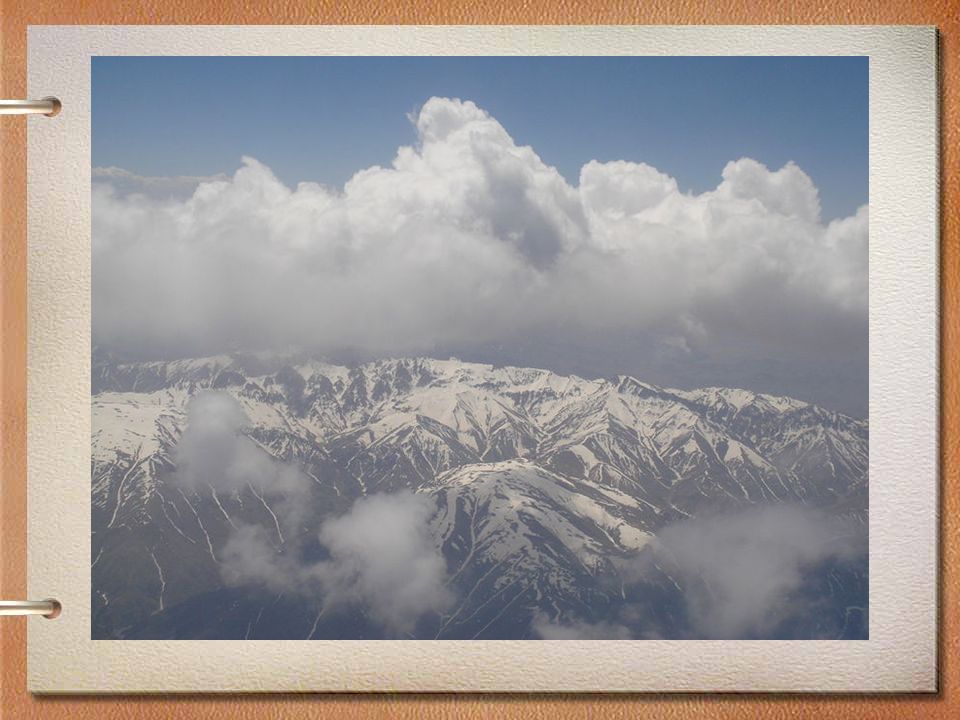
HIMALAYAS Separate India from other countries in the region Contains the world’s highest mountain, Mt. Everest (~29,000 ft above sea level)
.")
4
HIMALAYAS Formed by tectonic forces - convergence Earthquakes are common in region Among the youngest mountain ranges on the planet (70 million years old)
")
7
Hindu Kush Smaller in area than the Himalayas, but almost as high and just as rugged. Located mostly in Afghanistan. The word “kush” means “death.”

9
Khyber Pass Best known pass through the Hindu Kush. For centuries, traders and invaders traveled through this pass.

12
Kashmir Isolated valley in northern India. Famous for the production of a fine wool. Split between India, Pakistan and China.

15
Indo-Gangetic Plain Large plain formed by the Indus, Ganges and Brahmaputra Rivers. Most fertile and densely populated part of South Asia.

16
Indus River Largest river of Pakistan. The word “indus” means “river.” India’s name comes from this river.

17
DECCAN PLATEAU Makes up most of central and southern India Rugged area Access difficult Low population density

18
Deccan Plateau Large plateau (an elevated flat or hilly landmass) Bordered by mountains: –Vindhyas –Western Ghats –Eastern Ghats
 Bordered by mountains: –Vindhyas –Western Ghats –Eastern Ghats")
19
DECCAN PLATEAU

20
RIVER SYSTEMS Indus River and Ganges River are the two most important in the region Provide for farming (irrigation) and energy production (hydroelectric power)
 and energy production (hydroelectric power)")
21
GANGES RIVER Religious rituals of the Hindu include: –Bathing for purification and –Disposal of their deceased RESULT: One of the most polluted rivers in the world

22
Ganges River Largest river in India. Most holy river of Hinduism. Joins with Brahmaputra to create an enormous delta in Bangladesh.

23
GANGES RIVER POLLUTED RIVER

24
GANGES RIVER National Geographic article on the polluted state of the Ganges River –http://news.nationalgeographic.com/news/ 2011/11/111123-india-ganges-river- pollution/http://news.nationalgeographic.com/news/ 2011/11/111123-india-ganges-river- pollution/

25
Brahmaputra River Large river that starts in Tibet (China). Runs through India and Bangladesh. Name means “Son of Brahma.”

26
Thar Desert Large desert in India and Pakistan.

28
Western Ghats The Western Ghats create a “rain shadow.” Windward Side Leeward Side

29
Review: Physical Features Deccan Plateau Himalayas Hindu Kush Indo-Gangetic Plain Thar Desert Western Ghats Hindu Kush Himalayas Thar Desert Indo-Gangetic Western Ghats Deccan Plateau

30
Climates With monsoons to the South and East, there is heavy seasonal rainfall (India). Dry climates to the west (in Pakistan). Highland climates in the north (Pakistan, Nepal, Bhutan).
. Highland climates in the north (Pakistan, Nepal, Bhutan)..")
31
MONSOONS To the people of India, the monsoons are a source of life. Seasonal reversal of winds bring heavy rainfall or no rain at all. General onshore movement in summer, bringing rainfall (lots of it). General offshore flow in winter, resulting in little rain. Very distinctive seasonal precipitation
. General offshore flow in winter, resulting in little rain. Very distinctive seasonal precipitation.")
32
POTENTIALLY NEGATIVE EFFECTS OF MONSOONS Widespread flooding Property damage Destruction to agricultural lands Damage to transportation infrastructure Homelessness Disease Malnutrition Serious injury Death

33
Natural Hazards in South Asia Earthquakes Monsoons and Flooding Drought and Fires Tsunamis Cyclones

34
TSUNAMIS A series of ocean waves generated usually by an earthquake in the sea floor. In the deep ocean, the tsunami wave may only be a few inches high. The tsunami wave may come gently ashore or may increase in height to become a fast moving wall of turbulent water several meters high.

35
TSUNAMIS Video of March 11, 2011 tsunami in Japan http://video.nationalgeographic.com/vid eo/news/environment-news/japan- tsunami-2011-vin/http://video.nationalgeographic.com/vid eo/news/environment-news/japan- tsunami-2011-vin/ Video of tsunami in Sri Lanka http://video.nationalgeographic.com/vid eo/environment/environment-natural- disasters/tsunamis/tsunami-sri-lanka/http://video.nationalgeographic.com/vid eo/environment/environment-natural- disasters/tsunamis/tsunami-sri-lanka/

36
CYCLONES A cyclone is a hurricane that occurs in the South Pacific or Indian Oceans

37
CYCLONES More on cyclones from the National Oceanic and Atmospheric Administration http://oceanservice.noaa.gov/facts/cyclo ne.htmlhttp://oceanservice.noaa.gov/facts/cyclo ne.html

Similar presentations