Download presentation
Presentation is loading. Please wait.

1
GG3019/GG4027/GG5019 www.abdn.ac.uk/geospatial An Introduction to
Geographical Information Technology and GIS Systems and Geospatial Data Analysis David R. Green G12 – 2324

2
GeoDatabase Data Models
What is a geodatabase (data model) ESRI’s ArcGIS Geodatabase Data Models Marine Data Model (MDM) Application of the MDM (separate PPT)
 ESRI’s ArcGIS Geodatabase Data Models. Marine Data Model (MDM) Application of the MDM (separate PPT)")
3
Data Models ESRI ArcGIS (successor to ArcView) GeoDatabase
The geodatabase provides the common data access and management framework for ArcGIS that enables you to deploy GIS functionality and business logic wherever it is needed—in desktops, servers (including the Web), or mobile devices. With this architecture you have the tools to assemble intelligent geographic information systems (ESRI)
, or mobile devices. With this architecture you have the tools to assemble intelligent geographic information systems (ESRI)")
4
Data Models ArcGIS has a well-defined model for working with data
This generic model, called the geodatabase (short for geographic database), defines all the types of data that can be used in ArcGIS—for example, features, rasters, addresses, and survey measurements—and how they are represented, accessed, stored, managed and processed. The geodatabase is a common framework shared by all ArcGIS products and applications.
, defines all the types of data that can be used in ArcGIS—for example, features, rasters, addresses, and survey measurements—and how they are represented, accessed, stored, managed and processed. The geodatabase is a common framework shared by all ArcGIS products and applications.")
5
Data Models

6
Data Models (Geo)relational model Geodatabase model
relational model Geodatabase model")
7
Object-oriented data modeling lets you characterize features more naturally by letting you define your own types of objects, by defining topological, spatial, and general relationships, and by capturing how these objects interact with other objects.

8
Data Models The goal for the ArcGIS Data Models is to provide a practical template for implementing GIS projects. Common starting point results in the creation of data model design templates that simplify the integration of similar data sets at the local, state/provincial, national, and global levels.

9
Data Models The geodatabase offers you the ability to:
Handle rich data types. Apply sophisticated rules and relationships. Access large volumes of geographic data stored in both files and databases. The geodatabase is more than a manager of geographic data, it also implements sophisticated business logic that, for example, builds relationships between data types, such as topologies and geometric networks; validates data; and controls access.

10
Data Models The geodatabase supports multiple formats of spatial data including: · Simple features such as shape files · Custom features with business logic and editing rules · Attribute data · Metadata · Images · Raster/Grid data · CAD data

14
Data Models How does a GIS data model work?
An ArcGIS data model is written in a graphical model language (Visiotm) that provides both a diagram of the data structure as well as UML (Universal Modeling Language) code. UML code can be directly ported to the GIS to create an empty database structure defining all of the necessary relationships and dependencies.
 that provides both a diagram of the data structure as well as UML (Universal Modeling Language) code. UML code can be directly ported to the GIS to create an empty database structure defining all of the necessary relationships and dependencies.")
15
Data Models Data Dictionary UML

16
Data Models Health Address Agriculture
Historic Preservation and Archaeology Homeland Security Hydro Local Government Marine Petroleum Pipeline Telecommunications Transportation Water Utilities Address Agriculture Archiving Atmospheric Basemap Biodiversity Census Boundaries Defense-Intel Energy Utilities Forestry Geology

17
Data Models

18
Marine Data Collection
Image courtesy of PISCO, OSU

19
Marine data is collected through a wide range of:
Methods Instruments Time scales Periodicity Precision Accuracy

21
Marine Data Model The marine data model development will provide data managers with a readymade model for marine data so that they can spend more time at sea collecting data and in the lab analyzing their information, and less time at the computer planning the data structure. It should also be useful to GIS practitioners working as academic, government, or military oceanographers, coastal and marine resource managers, consultants, technologists, archaeologists, conservationists, geographers, fisheries managers, scientists, ocean explorers, and mariners alike (ESRI)
")
22
What is the MDM? A geodatabase template
A new way to spatially model marine data A database used to assemble, store and query data Model that captures the behavior of real-world objects The MDM model provide ready-to-use framework, built on accepted standards, for modeling and capturing the behavior of real-world objects in a geodatabase. Provide a way to effectively integrate 3D and 4D space and time. This is important because need for model to represent the multidimensional and dynamic nature of ocean data and processes. Do I need to go into detail about what a geodatabase is??

23
Purpose of Marine Data Model
Basic template for implementing GIS projects input, formatting, geoprocessing, creating maps, performing analyses Basic framework for writing program code and maintaining applications development of tools for the community Promote networking and data sharing through established standards

24
Georelational to Geodatabase Model
Coverage (Arc/Info) and shapefile (ArcView) data structures Features are aggregated into homogenous collections of points, lines, and polygons with generic, 1- and 2-dimensional "behavior" Can’t distinguish behaviors Point for a marker buoy, same as point for any observation “Smart Features” in a geodatabase
 and shapefile (ArcView) data structures. Features are aggregated into homogenous collections of points, lines, and polygons with generic, 1- and 2-dimensional behavior Can’t distinguish behaviors. Point for a marker buoy, same as point for any observation. Smart Features in a geodatabase.")
25
Geodatabase Concepts ESRI's new data object-oriented data model
objects, features, behaviors Object in ArcGIS an object is non-spatial it is NOT a point, line, or area it has no geographic location it has no shape attribute in its table ship, vehicle, … customer, lake, house Feature an object that has geographic location a point, line, area, TIN, raster

26
Geodatabase Concepts Geodatabase
Collection of feature data sets, rasters, TINs All data in relational tables Behavior is coupled with features through rules No more division between ARC and INFO (as in ESRI’s older GIS ArcInfo)
")
27
Data Models The common marine data types listed here are evolving and changing with review of the data model.

28
The primary ESRI feature classes are the building blocks of the data model.
These are the most commonly used features that provide a topological structure for the underlying data.

29
Steps in Data Model Process
Data model template – few weeks to months Mature data model – up to few years Draft Model Review, Projects Final Model

30
Steps in Data Modeling (1) Model the user's view of data
what are the basic features needed to solve the problem? (2) Select the geographic representation points, lines, areas, rasters, TINs (3) Define objects and relationships draw a UML diagram (4) Match to geodatabase elements specify relationships, “behaviors” (5) Organize geodatabase structure
 Select the geographic representation. points, lines, areas, rasters, TINs. (3) Define objects and relationships. draw a UML diagram. (4) Match to geodatabase elements. specify relationships, behaviors (5) Organize geodatabase structure.")
32
A visual representation of the elements of the data model as they relate to important aspects of marine data collection and analysis. Users’s View of Data

34
UML to ArcGIS 8

35
Some Marine Data Model Links

36
Some of the benefits of the geodatabase data model are:
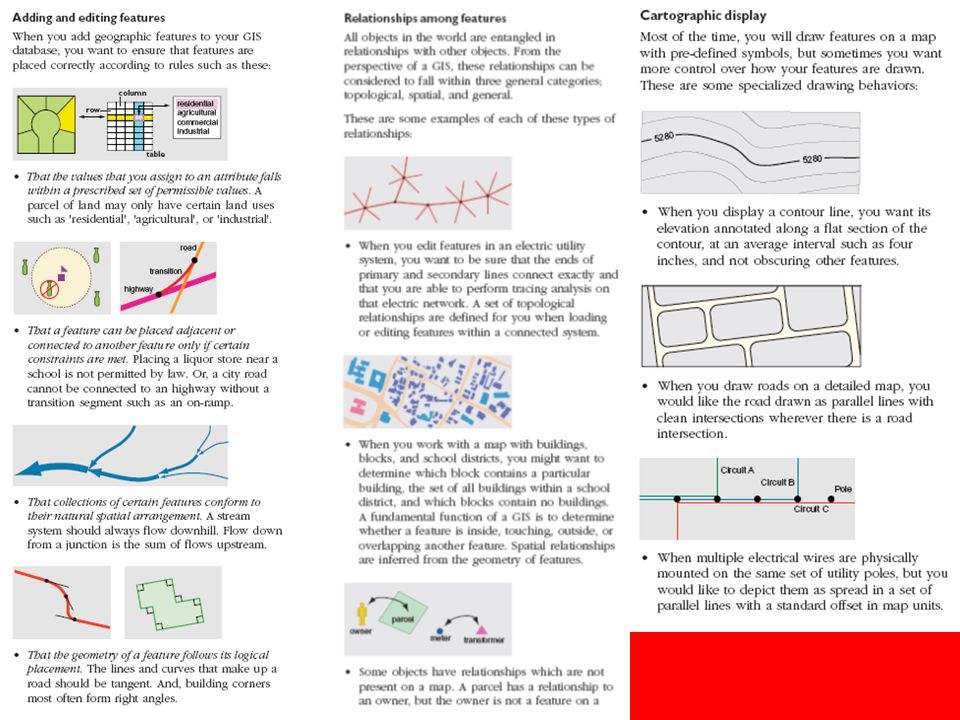
• A uniform repository of geographic data. All of your geographic data can be stored and centrally managed in one database. • Data entry and editing is more accurate. Fewer mistakes are made because most of them can be prevented by intelligent validation behavior. For many users, this alone is a compelling reason to adopt the geodatabase data model. • Users work with more intuitive data objects. Properly designed, a geodatabase contains data objects that corresponds to the user’s model of data. Instead of generic points, lines, and areas, the user works with their objects of interest such as transformers, roads, and lakes. • Features have a richer context. With topological associations, spatial representation, and general relationships, you not only define a feature’s qualities, but its context with other features. This lets you specify what happens to features when a related feature is moved, changed, or deleted. This context also lets you locate and inspect a feature that is related to another.

37
Better maps can be made. You have more control over how features are drawn and you can add intelligent drawing behavior. You can apply sophisticated drawing methods directly in ArcInfo’s mapping application, ArcMap. Highly specialized drawing methods can be executed through writing software code. Features on a map display are dynamic. When you work with features in ArcInfo, they can respond to changes in neighboring features. You can also associate custom queries or analytic tools with features. Shapes of features are better defined. The geodatabase data model lets you use define the shapes of features using straight lines, circular curves, elliptical curves, and Bezier splines. Sets of features are continuous. By their design, geodatabases can accomodate very large sets of features without tiles or other spatial partitions. Many users can edit geographic data simultaneously. The geodatabase data model supports work flows where many people can edit features in a local area, and then reconcile any differences that emerge.

Similar presentations


 - 2 © Richard Haddlesey www.medievalarchitecture.net.>")


 John Wiley and Sons Ltd 9. Geographic Data Modeling.>")
 Physical Model Modeling Process Conceptual Model Lists, flow diagrams, etc Logical.>")


 Longley et al., ch.>")


 Zeiler, chs. 4, 5, and 12 Review Zeiler ch. 1.>")