Download presentation
Presentation is loading. Please wait.

1
U.S. INTEGRATED OCEAN OBSERVING SYSTEM DATA ACCESS SERVICES Coastal Geotools: Advances in Federal Data Access Services Hassan Moustahfid, Chris Duncombe Rae, Derrick Snowden, Becky Baltes, and Robert Ragsdale, NOAA/US April 1, 2015

2
8 5 6 11 2 4 10 3 7 9 1 U.S. IOOS ® : Program Overview 2 Codified in law (P.L. No 111-11, March 2009) Partnership effort that leverages dispersed national investments to deliver ocean, coastal and Great Lakes data relevant to decision-makers 12 Coastal Component –17 Federal agencies –13 regional partners –Academia & Industry Global Component –US contribution to GOOS –64% of the Global Climate Ocean Observing System completed
 Partnership effort that leverages dispersed national investments to deliver ocean, coastal and Great Lakes data relevant to decision-makers 12 Coastal Component –17 Federal agencies –13 regional partners –Academia & Industry Global Component –US contribution to GOOS –64% of the Global Climate Ocean Observing System completed.")
3
What is DMAC? 2014-04-153 DMAC is the collection of people, process, and technology that enable the dissemination of diverse and distributed data sets using the WWW as the platform. IOOS is deploying, and in some cases building, infrastructure to enable this dissemination.

4
A layered view of the primary roles within IOOS/DMAC 2014-04-15Technical Solutions4

5
Exposing Data! 52014-04-15 Implementation across the enterprise Functional DACs complement the regional footprint

6
Anatomy of an RA DAC

7
7 Operational Use of HF Radar Surface Currents for Search And Rescue Surface Currents Search And Rescue Optimal Planning System (SAROPS) Data Acquisition Data Product Generation & Management 2014-04-15
 Data Acquisition Data Product Generation & Management")
8
HFR SAROPS as an example of the layered architecture in practice. THREDDS Servers 2014-04-15Technical solutions8

9
HF Radar Updates 9

10
IOOS Model Data Interoperability Design Clients NetCDF -Java NetCDF4 -Python ERDDAP ROMS ADCIRC HYCOM SELFENCOM FVCOM Observed data (buoy, gauge, ADCP, glider) MatlabPanoplyIDVArcGISPythonGodiva2 Common Data Model Apply Standardization Distribute via Web Services OPeNDAP+CF WCS NetCDF Subset WMS ncISO SOS Grid Ugrid TimeSeries Profile Trajectory TimeSeriesProfile 2015-04-01 Advances in a Distributed Approach for Ocean Model Data Interoperability; http://www.mdpi.com/2077-1312/2/1/194 10
 MatlabPanoplyIDVArcGISPythonGodiva2 Common Data Model Apply Standardization Distribute via Web Services OPeNDAP+CF WCS NetCDF Subset WMS ncISO SOS Grid Ugrid TimeSeries Profile Trajectory TimeSeriesProfile Advances in a Distributed Approach for Ocean Model Data Interoperability; 10")
11
Use Case: Model Data comparison using web services 33 Tb 4D model output on a triangular mesh grid CO-OPS offers 1019 data sets via their SOS containing water level and met parameters Plot the time series of observed water level and model simulation sampled at the observation locations, via web services. 2014-04-15Technical solutions11 http://tidesandcurrents.noaa.gov/map/

12
Model Data comparison con’t 2014-04-15 http://nbviewer.ipython.org/urls/raw.githubusercontent. com/rsignell- usgs/notebook/fef9438303b49a923024892db1ef3115e3 4d8271/CSW/IOOS_inundation.ipynb 12 Modify in your browser; Runs in the cloud; No need to download data;

13
Multi-sensor Improved Sea-Surface Temperature for IOOS 68 GHRSST Product Lines Now Archived - http://data.nodc.noaa.gov/geoportal/rest/find/document ?searchText=title%3AGHRSST&start=1&max=100&content Option=intersecting&f=searchPage&expandResults=True

14
Multi-scale Ultra-high Resolution (MUR) SST analysis, Global, 0.011 Degree, Daily http://coastwatch.pfeg.noaa.gov/erddap/griddap/jplMURSST.largePng?analysed_sst[(2015- 03-30T09:00:00Z)][(0.00549316):(55.0031)][(-134.995):(- 39.9957)]&.draw=surface&.vars=longitude|latitude|analysed_sst&.colorBar=||||| Access Methods THREDDS Hyrax Live Access Server WMS WCS ERDDAP Available Formats netCDF Images Esri ASCII Json Matlab OPeNDAP
![Multi-scale Ultra-high Resolution (MUR) SST analysis, Global, Degree, Daily analysed_sst[( T09:00:00Z)][( ):( )][( ):( )]&.draw=surface&.vars=longitude|latitude|analysed_sst&.colorBar=||||| Access Methods THREDDS Hyrax Live Access Server WMS WCS ERDDAP Available Formats netCDF Images Esri ASCII Json Matlab OPeNDAP](http://images.slideplayer.com/29/9435106/slides/slide_14.jpg "Multi-scale Ultra-high Resolution (MUR) SST analysis, Global, Degree, Daily analysed_sst[( T09:00:00Z)][( ):( )][( ):( )]&.draw=surface&.vars=longitude|latitude|analysed_sst&.colorBar=||||| Access Methods THREDDS Hyrax Live Access Server WMS WCS ERDDAP Available Formats netCDF Images Esri ASCII Json Matlab OPeNDAP")
15
Comparison of 1km Data Sets MODIS SST (4 micron) Courtesy NASA GSFC OBPG JPL G1SST Courtesy Yi Chao, UCLA
 Courtesy NASA GSFC OBPG JPL G1SST Courtesy Yi Chao, UCLA")
16
A network of underwater profiling gliders catalog.ioos.us/gliders

17
Multi-disciplinary and multi-mission capabilities 17 Climate/Ecosystem/Fisheries Management/Water Quality Hurricane Forecasting Response to Oil Spill The SoCal Niño Index CalCOFI Fish Tracking HAB Deep Water HorizonAlaska Hypoxia Exercising the Network

18
Glider DAC Update 18 National standards to ease exchange of data from regional glider operators Real-time distribution to non-federal and federal partners Share your data Let us make it easier Archiving

19
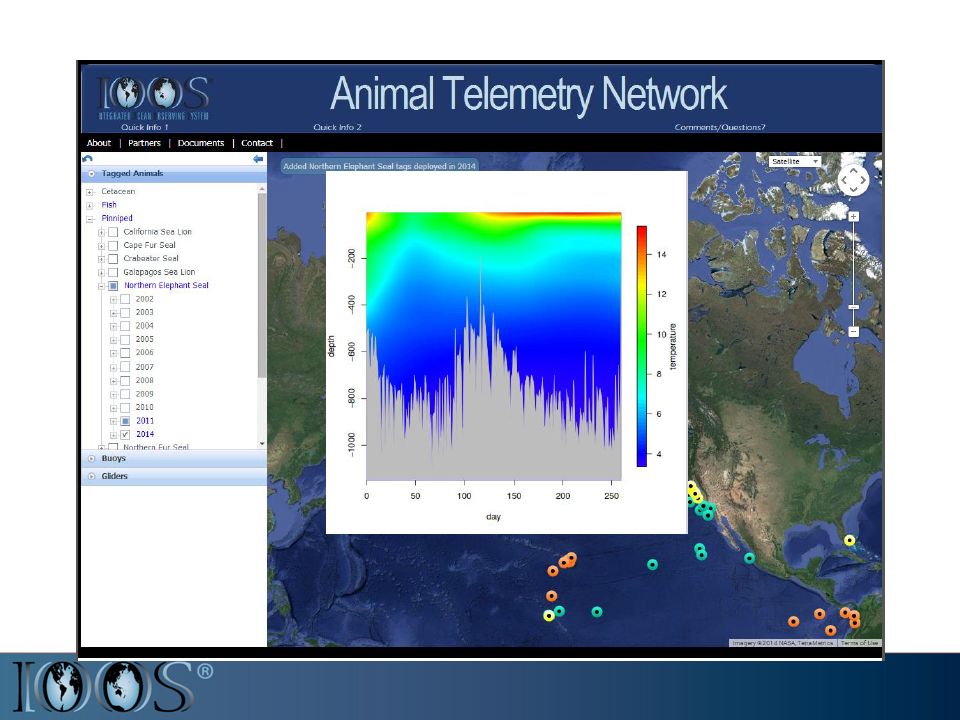
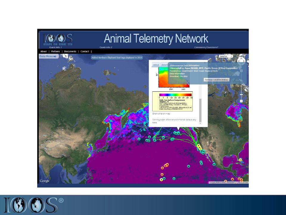
Biological and Physical Data Integration Beta version of marine mammal health mapping tool

20
oceanview.pfeg.noaa.gov/ATN

Similar presentations


 Plan for Data Management.>")
 Howlett ASA Inc. Narragansett, RI SECOORA/SEACOOS Workshop.>")
 We need advanced tools to understand and monitor our oceans, coasts and Great Lakes.>")


 Enabling decision making every day; Fostering advances in science and technology.>")


