Download presentation
Presentation is loading. Please wait.

1
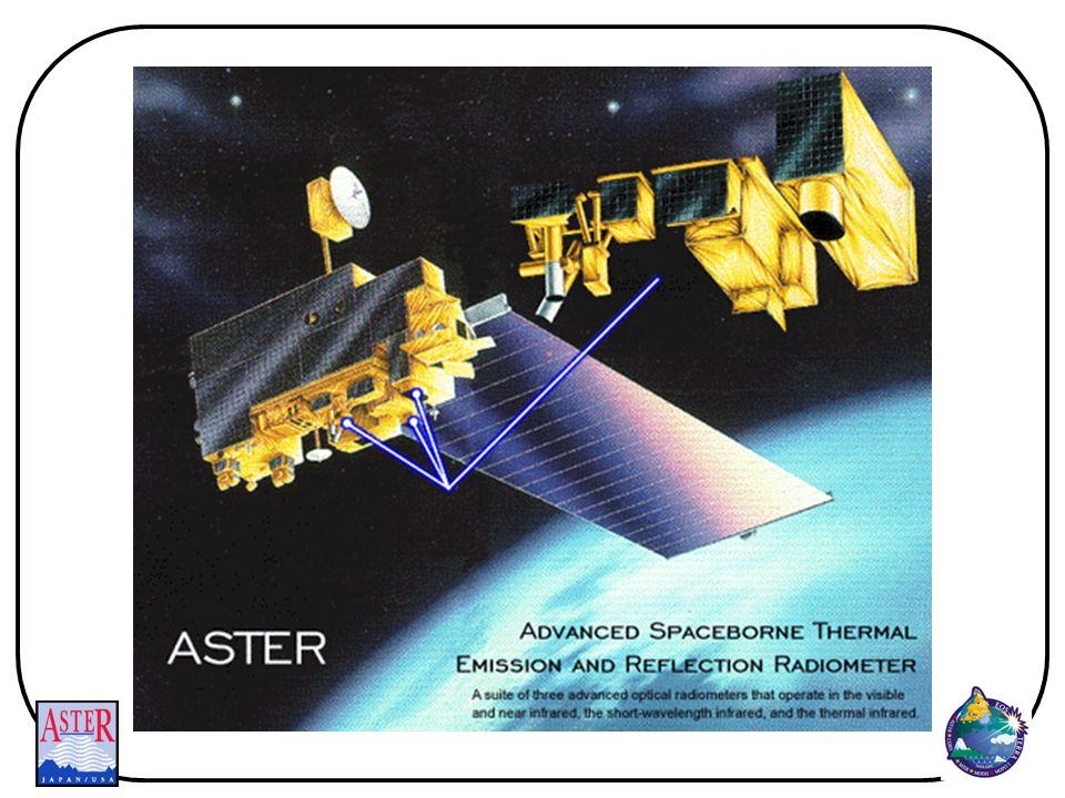
Advanced Spaceborne Thermal Emission and Reflection Radiometer
ASTER Advanced Spaceborne Thermal Emission and Reflection Radiometer

4
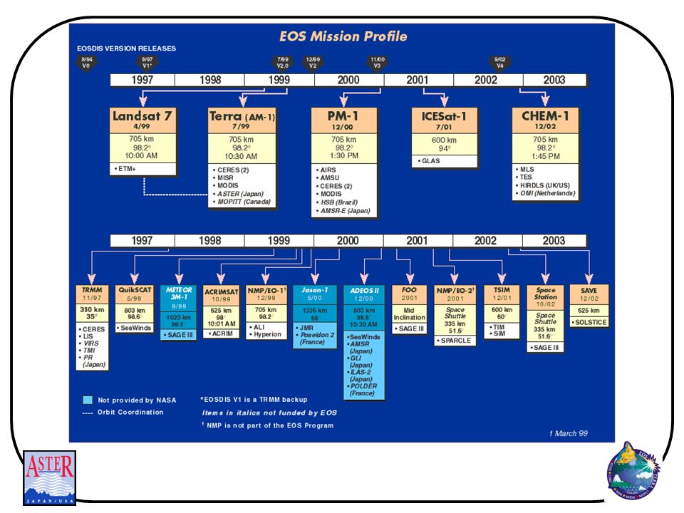
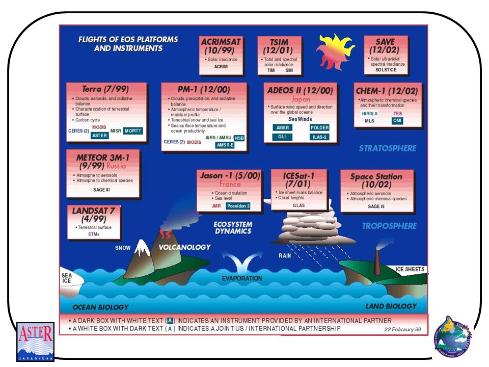
Terra Instruments ASTER - Advanced Spaceborne Thermal Emission and Reflection Radiometer CERES - Clouds and Earth's Radiant Energy System MISR - Multi-angle Imaging Spectro Radiometer MODIS - Moderate Resolution Imaging Spectro-Radiometer MOPITT - Measurements of Pollution in the Troposphere

5
Terra Orbit Parameters
Orbit Sun Synchronous Descending Node Time of Day 10:30 am Altitude 705 km Inclination 98.2o Repeat Cycle 16 days

7
ASTER Instrument Overview
ASTER is an international effort: Japanese government is providing the instrument under MITI (Ministry of International Trade and Industry) and is responsible for Level 1 data processing Will fly on NASA’s Terra platform Science team consists of Japanese, American, Australian, and French scientists
 and is responsible for Level 1 data processing. Will fly on NASA’s Terra platform. Science team consists of Japanese, American, Australian, and French scientists.")
8
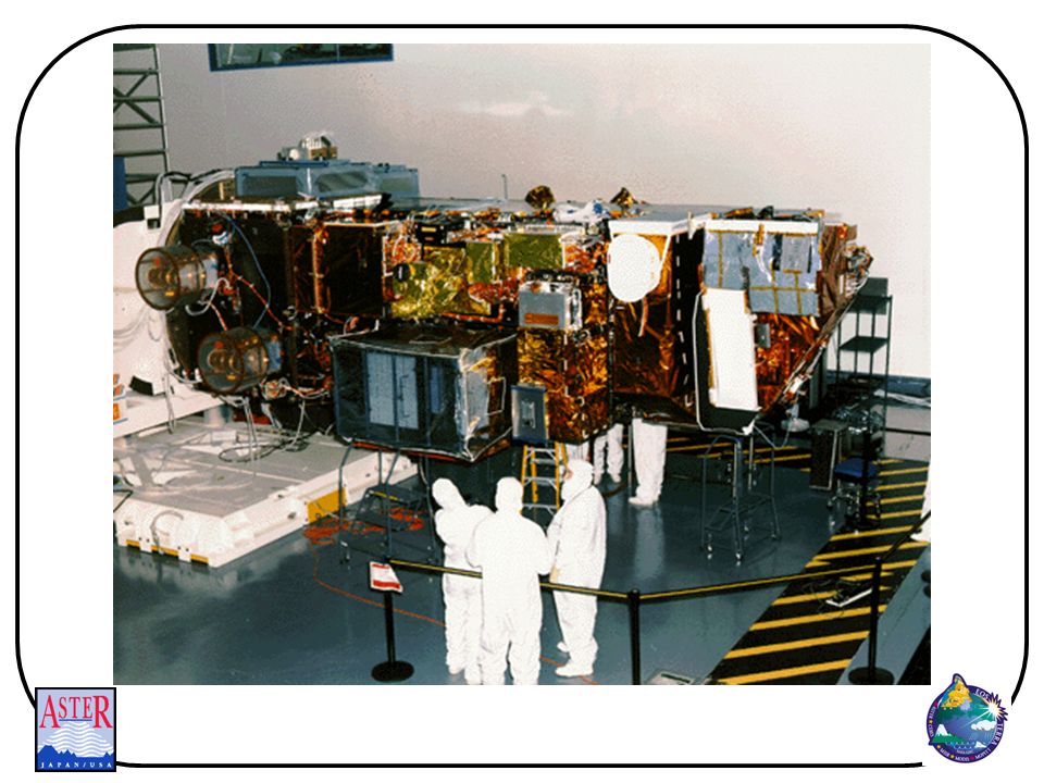
ASTER Instrument Advanced Spaceborne Thermal Emission and Reflection Radiometer 1999 launch on Terra Joint Japan/US effort 15m visible, 30 m swir, 90 m tir 60 km swath < 16 day repeat cycle

11
ASTER Bands

12
ASTER Science Team Consists primarily of Japanese and US members
Conducts scientific research related to EOS goals using ASTER data Provides scientific guidance to hardware builders: - functional requirements - design issues - calibration - modes of operations

13
ASTER Science Team Selects algorithms for higher level standard products Produces software for standard products Conducts joint calibration and validation exercises Conducts mission operations, scheduling, and mission analysis

14
ASTER Instrument Operations
ASTER has a limited duty cycle which implies decisions regarding usage must be made Observation choices include targets, telescopes, pointing angles, gains, day or night observations Telescopes capable of independent observations and maximum observation time in any given orbit is 16 minutes Maximum acquisitions per day Acquired ~750 Processed ~330

15
ASTER Instrument Operations
Number of pointing changes over life of mission limited to 10, approximately 1 per 2.5 orbits for VNIR and SWIR Pointing changes to be made during nighttime part of orbit These limitations allow a maximum of 1.7 million scenes over the life of the mission

16
Science Prioritization of ASTER data acquisition
NASA HQ, GSFC, and MITI have charged the Science Team with developing the strategy for prioritization ASTER data acquisition Must be consistent with EOS goals, the Long Term Science Plan, and the NASA-MITI MOU Must be approved by EOS Project Scientist

17
Global Data Set A one-time acquisition
All land surfaces, including stereo Maximize high sun “Optimal” gain Consists of pointers to processed and archived granules which: Meet the minimum requirements for data quality Are the “best” acquired satisfying global data set criteria Science Team has prioritized areas for acquisition (high, medium and low)
")
18
Regional Data Sets Focus on specific physiographic regions of Earth, usually requiring multi-temporal coverage Acquisitions are intended to satisfy multiple users, as opposed to specific requirements of individual investigator or small team Defined by the ASTER Science Team in consultation with other users (e.g., EOS interdisciplinary scientists) Science team provides prioritization (relative to other regional data sets) on a case-by-case basis
 Science team provides prioritization (relative to other regional data sets) on a case-by-case basis.")
19
Targeted Observations
Targeted observations are made in response to Data Acquisition Requests (DARs) from individual investigators or small groups for specific research purposes Japanese Instrument Control Center (ICC) does prioritization of DAR based on guidelines provided by Science Team Targeted observation may also be used to satisfy the global data set or regional data set acquisition goals, where appropriate
 from individual investigators or small groups for specific research purposes. Japanese Instrument Control Center (ICC) does prioritization of DAR based on guidelines provided by Science Team. Targeted observation may also be used to satisfy the global data set or regional data set acquisition goals, where appropriate.")
20
End-to-End Data System Architecture
TDRS EOS AM-1 Spacecraft (5) Direct Downlink (Pending) ASTER GDS Japan Authorized User (4) Uplink (Schedule) EOSDIS (6) L0 data (7) L2 Products (5) Downlink (Science and Engineering data) U.S. (6) Housekeeping Data (3) Schedule (2) Data Acquisition Requests (1) Request (8) Products
 Direct Downlink. (Pending) ASTER. GDS. Japan. Authorized. User. (4) Uplink. (Schedule) EOSDIS. (6) L0 data. (7) L2 Products. (5) Downlink. (Science and. Engineering data) U.S. (6) Housekeeping Data. (3) Schedule. (2) Data Acquisition Requests. (1) Request. (8) Products.")
21
How Will I Get ASTER Data
Browse the archive: use the EOS Data Gateway (EDG) to find what data have already been acquired. Order data products desired: Submit a Data Acquisition Request: First become an authorized user; then request satellite obtain your particular data
 to find what data have already been acquired. Order data products desired: Submit a Data Acquisition Request: First become an authorized user; then request satellite obtain your particular data.")
22
Scientists Authorized to Submit DARs
ASTER Science Team Other EOS Instrument Team members EOS Interdisciplinary Science Teams Other scientists “registered” by Japan

23
Authorizing Non-EOS Users to Request ASTER Acquisition
U.S. PROCESS FOR AUTHORIZING NON-EOS ASTER USERS: Interested ASTER user sends proposal electronically Proposal forms, and ASTER information, will be available on-line Proposal (1-2 pages long) can be submitted electronically at any time Each proposal includes estimate of number of ASTER scenes Proposals evaluated by committee: ASTER Team Members, NASA HQ, external scientists Most proposals evaluated within few weeks Notice of acceptance or rejection sent by Once authorized, new user can request that ASTER acquire new data U.S. users submit ASTER DARs via DAR Clients, provided by ECS SPECIFIC NUMBER OF ASTER SCENES ALLOCATED TO EACH SUCCESSFUL PROPOSAL Scenes are allocated based on estimated requirements (included in proposal)
 can be submitted electronically at any time. Each proposal includes estimate of number of ASTER scenes. Proposals evaluated by committee: ASTER Team Members, NASA HQ, external scientists. Most proposals evaluated within few weeks. Notice of acceptance or rejection sent by . Once authorized, new user can request that ASTER acquire new data. U.S. users submit ASTER DARs via DAR Clients, provided by ECS. SPECIFIC NUMBER OF ASTER SCENES ALLOCATED TO EACH SUCCESSFUL PROPOSAL. Scenes are allocated based on estimated requirements (included in proposal)")
24
ASTER Standard Data Products
Level-1 Data Decorrelation Stretch: VNIR, SWIR, TIR Brightness Temperature Surface Reflectance/Radiance: VNIR & SWIR Surface Reflectance/Radiance: TIR Surface Emissivity Surface Kinetic Temperature Digital Elevation Model

25
Death Valley 14 radiance channels

26
VNIR SWIR TIR Death Valley

27
Death Valley

28
Death Valley Temperature image from temp-emissivity separation

29
Death Valley Emissivity images from T-E separation

30
Death Valley Emissivity images from T-E separation

31
Death Valley (top) VNIR-SWIR + ASTER DEM (bottom) TIR + ASTER DEM 60 x 60 km image
 VNIR-SWIR + ASTER DEM (bottom) TIR + ASTER DEM 60 x 60 km image")
32
Popocatepetl Volcano, Mexico

33
SO2 Recovery

34
Po River Delta

36
Po River Delta

37
Po River Delta

38
Cloud and Ice Separation Antarctica

39
Urban Land Use Scottsdale, AZ

40
ASTER Web Site:

Similar presentations


 M. Fujita, T. Tachikawa, M. Kato, H. Tsu ( ERSDAC, Japan), M.J. Abrams, L. Maldonado.>")


. Why TRMM? n Tropical Rainfall Measuring Mission (TRMM) is a joint US-Japan study initiated in 1997 to study.>")


 and Landsat Thematic Mapper (TM) Sensor System Characteristics.>")


