Download presentation
Presentation is loading. Please wait.

1
BURGESS Model Urban Land Use Model

3
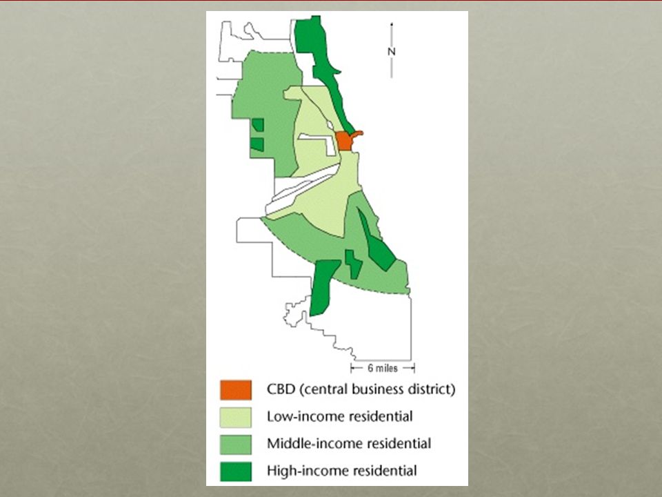
Chicago in 1920s

4
Concentric model It was put forward by Ernest W. Burgess (sociologist) and his associates in 1920s. It was based on empirical research in a number of American cities, like Chicago. Main ideas of the model: Ecological approach to explain land use pattern Residential segregation + Social segregation Spatial pattern of various land use zones

5
ECOLOGICAL Concepts of the model
Burgess adopted the concepts used by plant ecologists (ideas of competition, dominance, invasion and succession) within the city, people competes for limited space (COMPETITION) those who are best able to pay (DOMINANCE) achieve the most desirable locations (INVASION and SUCCESSION). those individuals and functions with the lowest level of economic competence have the least choice, occupying the poorest locations.
 within the city, people competes for limited space (COMPETITION) those who are best able to pay (DOMINANCE) achieve the most desirable locations (INVASION and SUCCESSION). those individuals and functions with the lowest level of economic competence have the least choice, occupying the poorest locations.")
6
How did Burgess explain land uses in Chicago?
The CBD, the most accessible location attracted all sorts of commercial activities Shortage of land induced keen competition The location was dominated by those activities with high rental capacity

7
How did Burgess explain land uses in Chicago?
This is caused by growth of city economy & arrival of new migrants to the city. As the city grew, the CBD would exert pressure on the zone immediately surrounding it i.e. the zone of transition Outward expansion of the CBD would invade nearby residential areas causing them to expand outwards.

8
How did Burgess explain land uses in Chicago?
The process was thought to continue with each successive neighbourhood moving further from the CBD. New immigrants would move into the cheapest residential areas of the city. When they became economically established, they would migrate outwards. Thus lower residential class moved to adjacent neighbourhoods and more affluent residents moved further outwards.

9
Bid-rent mechanism APPLIES
land value decreases with increasing distance. the highest land value is at the city centre because of keenest competition.

10
functional zoning and residential segregation
= within different areas of the city, different single functions formed the dominant element.

11
Concentric Model C.B.D. Transition Zone Low class residential
Commuter’s zone Transition Zone Middle class residential Low class residential

15
CBD at the heart of the city
forms the commercial, social and cultural hub. the most accessible, at the focus of urban transport network

18
Chicago’s inner city “slums” 1920s
Chicago’s Gold Coast 1930s

19
Zone in transition Surrounds the CBD
an area of ‘blight’, also called the twilight zone. An area of mixed land uses – wholesale, light manufacturing, residential Provides cheap housing for each new immigrant wave the zone often characterized by slums, immigrant ghettoes, unstable and low social groups and crime. poorest residential areas.

22
Zone of workingmen’s homes
surrounds the transition zone has some of the older, often terraced housing areas of the city occupied by workers who have left the transition zone but who still require ready access to their places of work in the inner zone. They left transition zone because they want better living conditions. 2nd generation immigrants form an important element of the pop. in this zone.

24
Zone of better residence (middle-class housing)
usually single-family dwellings in semi-detached or detached houses also some light industry in this zone, often in industrial estates.

26
Commuter Zone lies beyond the continuous built-up area of the town, at the fringe of the urban area. consists of discontinuous urban settlement interspersed with recreational facilities, woodland, pastures. is the zone of high class residential properties where people can afford the high costs of commuting.

30
Discussion Can you apply the ecological concepts suggested by Burgess to explain the land use changes in Hong Kong?

31
Socio-economic characteristics
Social status wealth Income Education level occupation Ethnics People of different races Majorities vs minorities Family structure Family size Family composition Age Sex

32
Socio-economic status
Near city centre Towards the periphery People of lower socio-economic status usually have lower income due to lower skills and poorer education so they occupy some less favourable sites, e.g. the slums in the inner city or squatter areas at the edge of the inner city People of higher socio-economic status usually have higher income (more affluent) due to more professional occupation and their higher educational background. as they look for better living environment and higher quality of life. Conclusion: Positive correlation between socio-economic status of households with distance from the CBD.
 due to more professional occupation and their higher educational background. as they look for better living environment and higher quality of life. Conclusion: Positive correlation between socio-economic status of households with distance from the CBD.")
33
Ethnic groups in a city Ethnic groups are new immigrants from other foreign countries, e.g. the Chinese, the Italians, the Japanese in some US cities Ethnic groups tend to cluster toegther as: They can cooperate, unite together or defend themselves when encounter any problems in the neighbourhood They can feel less isolated from the city in order to integrate themselves into the community They usually have lower social status / bargaining power to compete for a favourable site occupy the inner city areas Examples: China town (Leicester Square) in London, Little Sicily in Chicago
 in London, Little Sicily in Chicago.")
34
Far away from city centre (Peripheral areas)
Family structure Near city centre Far away from city centre (Peripheral areas) Family size Small families occupy less space as they can afford the small flats near city centre Big families as they need more space for children so they look for larger space of lower land rent Family average age Old people usually have lower mobility Young family have higher mobility Family structure Young professional (yuppies) lives close to city centre to look for entertainment, e.g. rise of Soho District
 Family size. Small families occupy less space as they can afford the small flats near city centre. Big families as they need more space for children so they look for larger space of lower land rent. Family average age. Old people usually have lower mobility. Young family have higher mobility. Family structure. Young professional (yuppies) lives close to city centre to look for entertainment, e.g. rise of Soho District.")
35
Early stage of urbanization
People tended to reside near the CBD to minimize the distance travelled so as the transport cost

36
suburbanization As real incomes have risen and better transportation has increased mobility, this allows the separation of home and workplaces. Wealthy people moved out of the inner city which was later Invaded by poorer ethnic minorities due to rising immigrants to the city. To offset high land value in these near- city locations, they use only small amount of land by living in high density apartments which make maximum use of expensive land. Occupied by wealthier people who could afford the higher transport cost when moving out of the city centre. Wealthy people can occupy larger amount of cheaper residential land on the periphery where they live in detached dwellings and pay the high commuting costs to city centre.

37
Results of suburbanization
social segregation = creating particular groups or classes which segregate themselves from other groups. poor people living close to the city centre on high value land, while more wealthy people live on the periphery where land is generally cheaper. As reflected by the quality of housing different in life styles + quality of life, income and social status

38
Weaknesses of burgess model
Concentric zones are not homogenous but heterogeneous therefore, they are not distinctive and inevitably distorted by major transport axes and topography features.

39
Criticisms Limited universality: it is limited “to a particular situation, at a particular time in a particular country” (Carter, 1976) The setting of the model was based on a particular historical & cultural context. It is most relevant to American cities in the 1920s but is less relevant to other times and other cities especially in ELDCs.

40
Criticisms it has allowed many centres of employment to grow outside the CBD due to increased mobility large plots of land are only available in the urban fringe, thus lower class residential areas are found in the outer zone due to inefficient transport. It enables low class residents to move away from their place of work. The decline of the CBD and the emergence of suburban business centres Increasing level of public intervention Transport innovation

41
Criticisms Use for understanding residential pattern better than commercial and industrial land uses

42
Contributions It was the first attempt to analyse the internal morphology of town Burgess model has invaluable contribution for residential land use of a city. It suggests a process of urban growth that might give rise to these. It provides a good conceptual framework for more detailed study of the complex urban land use.

Similar presentations


 in 1939 Studied 64 widely distributed American cities Publication:>")


 and his associates in 1920s. It was put forward.>")
>")