Download presentation
Presentation is loading. Please wait.

1
Map Skills/ Latitude and Longitude
Visual Vocabulary Today’s Date: August 31th, 2017 Today’s Title goes onto Page 2 Today’s Title: Map Skills Today’s Essential Question (Which goes on the top of Page 2): What are the basic features and functions of a map?
: What are the basic features and functions of a map")
2
Scale Represents the distance between two locations on the map. Ex: 1 inch on the map equals 1 mile on the ground

3
Map Key A small chart included on a map that gives descriptions of what symbols are used and what they stand for.

4
A picture that is used to represent an object on a map
Symbol A picture that is used to represent an object on a map

5
Can you understand this legend?

6
Age Expectancy Legend

7
A design on a map that shows directions
Compass Rose A design on a map that shows directions

8
Cardinal Directions The four major compass points of North, South, East, West used to navigate a map

9
Intermediate Directions
The in-between compass points of Northeast, Northwest, Southeast, Southwest

10
How do we find places on maps?
Map Skills How do we find places on maps?

11
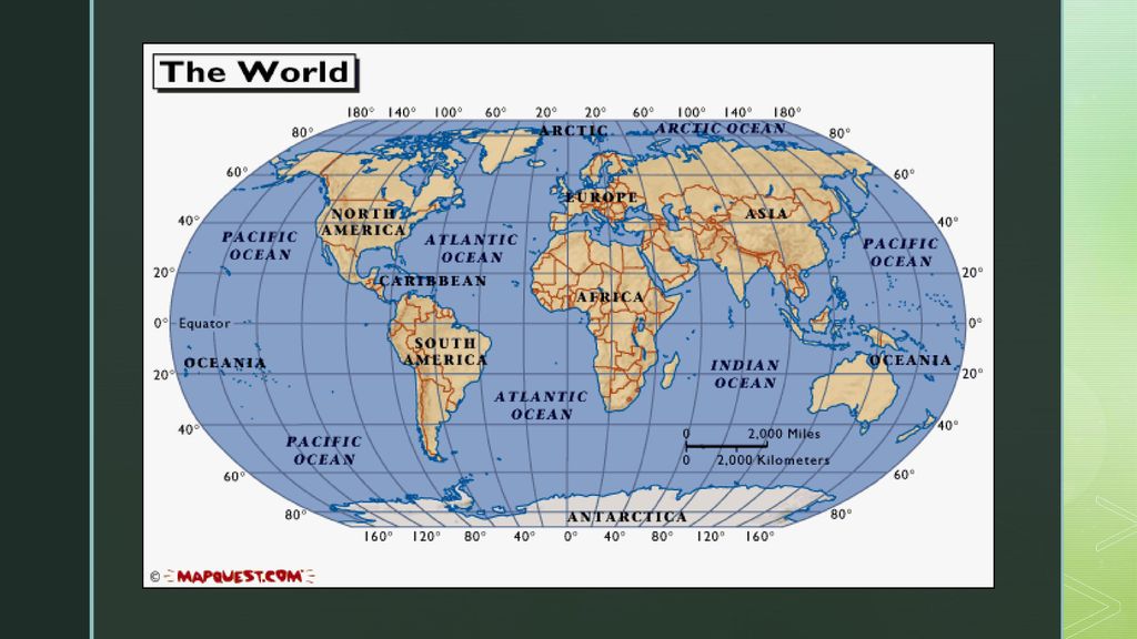
Latitude Lines run horizontally Measured in degrees.
The Equator is 0 degrees Latitude. Latitude lines are called parallels. Latitude

12
The Equator Imaginary belt that runs halfway between the North Pole and the South Pole.

13
Longitude Lines of Longitude run vertically. Called Meridians
Prime Meridian is the main line of longitude East or West of the Prime Meridian. Prime Meridian is found in Greenwich, England and is 0 degrees Longitude. Longitude

14
Longitude Lines of longitude begin at the Prime Meridian.
60° E is the 60° line of longitude east of the Prime Meridian. 60° W is the 60° line of longitude west of the Prime Meridian. The Prime Meridian is located at 0°. It is neither east or west W E TEKS: Social Studies – 6.22 (A), Using social studies terminology correctly 7.22 (A), 8.31 (A)
, Using social studies terminology correctly (A), 8.31 (A)")
15
Hemispheres The Equator splits the earth into the northern and southern hemisphere The Prime Meridian splits the earth into Eastern and Western hemisphere

18
Your Foldable STEP ONE! Cut out the template for you and a partner
STEP TWO! Cut down in-between the strips so you will be able to write underneath each one STEP THREE! Fill out the notes! STEP FOUR! When we’re done, you will glue or tape it into your Notebook

19
Turn to PAGE 10!!!! Copy these terms.
Geography Terms KEY: A key, or legend, is a small box that lists symbols and tells what they stand for SCALE: A scale is a set of lines marked off in miles and kilometers. It allows you to estimate distance between points on a map COMPASS: A compass is a tool that has at least four pointers that show the cardinal directions. They may also show intermediate directions.

20
Draw and Label the Compass
NW NE SW SE

21
The EQUATOR Invisible Line that runs East to West and divides the earth into Hemispheres (THE BELT)
The PRIME MERIDIAN Invisible line that runs from the NORTH Pole to the SOUTH Pole that divides the Earth into hemispheres

22
The Cardinal Directions are North, East, South, and West (N, E, S, W).
The Intermediate Directions are Northeast, Southeast, Northwest, and Southwest (NE, SE, NW, SW) LATITUDE/LONGITUDE: Latitude lines are imaginary lines that circle the earth from East to West. They run parallel to the Equator, 0 Degrees Latitude. (Like a Ladder) Longitude lines are imaginary lines that run North to South. The Prime Meridian is 0 degrees Longitude
 LATITUDE/LONGITUDE: Latitude lines are imaginary lines that circle the earth from East to West. They run parallel to the Equator, 0 Degrees Latitude. (Like a Ladder) Longitude lines are imaginary lines that run North to South. The Prime Meridian is 0 degrees Longitude.")
Similar presentations