Download presentation
Presentation is loading. Please wait.

1
Introduction to Geographic Information Systems (GIS) using ArcMap 9.2 Marcel Fortin GIS & Map Librarian, University of Toronto gis.maps@utoronto.ca www.library.utoronto.ca/maplib September 27 th, 2007 This presentation http://prod.library.utoronto.ca:8090/maplib/temp/RCAT/http://prod.library.utoronto.ca:8090/maplib/temp/RCAT/
 using ArcMap 9.2 Marcel Fortin GIS & Map Librarian, University of Toronto September 27 th, 2007 This presentation")
2
Objectives ► Understand the basic premises of GIS Cartography / Map Making Geographic Analysis ► By Learning the basics of GIS software and databases Different geographic datasets Basic map creation

3
Objectives ► What is GIS? ► Examples of GIS ► Issues and problems/obstacles to using GIS ► GIS software and Data ► Hands-on

4
What is GIS? A GIS is a computer application with the capacity to assemble, store, manipulate, analyze, and display geographically referenced information (geospatial data)
.")
5
What are Geospatial data? Data must “fit” with other data Geospatial data are georeferenced data (ie. they have a geographic field) postal codes postal codes Province Province City City longitude and latitude longitude and latitude lot numbers lot numbers concession numbers concession numbers census tract census tract wards wards etc. etc.
 postal codes postal codes Province Province City City longitude and latitude longitude and latitude lot numbers lot numbers concession numbers concession numbers census tract census tract wards wards etc. etc..")
6
Provinces

7
Postal Data

8
Longitude / Latitude

9
Parcel Information

10
Air Photos (or other raster imagery) 0.5000000 0.0000000 -0.5000000 627995.1250249 4836671.8749751 1999 Aerial photograph (Triathlon Inc.) Access via http://atlantis.chass.utoronto.ca/maplib/cgi-bin/datainventory.pl?idnum=44&display=full
 Aerial photograph (Triathlon Inc.) Access via idnum=44&display=full")
11
Road Network File DMTI Spatial’s Street Network File for Ontario http://atlantis.chass.utoronto.ca/maplib/cgi-bin/datainventory.pl?idnum=450&display=full

12
Combination of “Layers” 1999 Orthorectified Aerial photograph overlayed with the DMTI Spatial’s Street Network file for Ontario

13
Common Examples of GIS

14
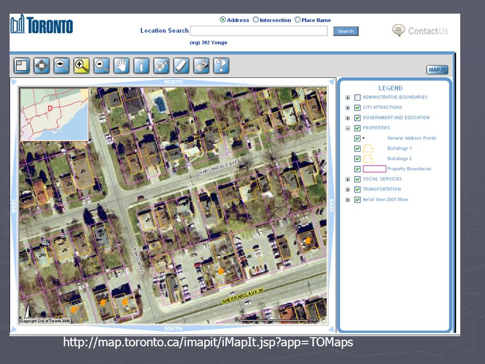
http://map.toronto.ca/imapit/iMapIt.jsp?app=TOMaps

16
Historical GIS 1860’s Map of Toronto with the Gardiner Expressway overlayed. Note the highway’s location!

17
What is not GIS?

18
What is not a GIS – Scanned Maps

19
E-maps are not a GIS http://www.ladocumentationfrancaise.fr/cartotheque/decoupage-administratif-france-2005.shtml

20
GPS IS NOT GIS http://www.skyfly.cz/pristroj/image/mage315.jpg

21
Future GPS / GIS Convergence 11 GPS.mxd

22
GIS not CAD

23
Data Access http://www.library.utoronto.ca/maplib

24
Software ESRI Site License (campus consortium) ArcGIS (desktop)ArcGIS (desktop) ArcInfoArcInfo ArcEditorArcEditor ArcView (free version now available from map library)ArcView (free version now available from map library) ArcIMS (web) / ArcSDE (spatial data engine)ArcIMS (web) / ArcSDE (spatial data engine) Mapinfo Site License (through Geography Department) Autocad Map Site License
 ArcGIS (desktop)ArcGIS (desktop) ArcInfoArcInfo ArcEditorArcEditor ArcView (free version now available from map library)ArcView (free version now available from map library) ArcIMS (web) / ArcSDE (spatial data engine)ArcIMS (web) / ArcSDE (spatial data engine) Mapinfo Site License (through Geography Department) Autocad Map Site License")
25
Other software options Commercial Microsoft MapPoint (software licensing office)Microsoft MapPoint (software licensing office) OracleOracle FMEFME Open Source GRASS (desktop)GRASS (desktop) MapServer (web)MapServer (web) ThubanThuban QGISQGIS
Microsoft MapPoint (software licensing office) OracleOracle FMEFME Open Source GRASS (desktop)GRASS (desktop) MapServer (web)MapServer (web) ThubanThuban QGISQGIS")
26
Making Sense of “ArcWording” Functions Umbrella Flavour 3D Analyst, Spatial Analyst, etc. Extensions ArcGISArcInfoArcEditorArcView ArcMap|ArcToolbox|ArcScene|ArcCatalog

27
Questions or Comments?

Similar presentations
 - 2 © Richard Haddlesey www.medievalarchitecture.net.>")


