Download presentation
Presentation is loading. Please wait.

1
Introduction to GIS and ArcGIS How a GIS works Introduction to ArcGIS The ArcGIS Interface

2
A GIS integrates five basic components data method s software people hardware

3
Data

4
Types of datasets Vector formats (“feature classes”) Points Lines (”arcs”) Polygons
 Points Lines ( arcs ) Polygons")
5
Types of datasets Raster formats Matrices of square cells (grids, pixels)
")
6
Types of datasets Attribute tables: tables of data describing spatial features

7
Methods

8
Basic GIS Functions Capture Store Query Analyze Display Output

9
Capturing data Paper mapsDigital images GPS output Coordinate lists

10
Query Identifying specific features Where is parcel No. 2945? Identifying features based on conditions Find all trees with DBH > 35 cm

11
Analysis Proximity : which roads are within a 100 ft from a stream Overlay: combines the features of two or more layers to create a new layer (intersections, unions…) Network: examines how linear features are connected
 Network: examines how linear features are connected")
12
Analysis

14
Display ► ► Maps ► ► Graphs ► ► Reports/Tables

15
Examples of GIS maps surface drapes & 3-D modeling

16
Examples of GIS generated maps detailed topographic maps

17
Output ► ► Paper map ► ► Internet ► ► Image (cc.jpg, cc.pdf) ► ► Document (cc.mxd) ► ► Poster
 ► ► Document (cc.mxd) ► ► Poster")
18
How a GIS works Introduction to ArcGIS The ArcGIS Interface

19
What is ArcGIS? ArcGIS Clients Application/Data Servers Components ArcGIS Desktop EXTENSIONSEXTENSIONS ArcGIS Engine ArcObjects RDBMS ArcSDE ArcGIS Server ArcIMS EXTENSIONSEXTENSIONS Network ArcReader ArcView ArcInfo ArcEditor Custom Application ArcPad Web Browser

20
ArcGIS Desktop Products Increased Functionality ArcView ArcInfo ArcEditor

21
The history of ESRI products time ArcInfo ArcView ArcGIS ArcView ArcEditor ArcInfo

22
All ArcGIS products share common applications ArcView ArcInfo ArcEditor ArcCatalog-window to database ArcMap-displaying ArcToolbox-geographic processing functions

23
What is unique about ArcGIS GIS? GUI (Graphic User Interface) Desktop Use Customization & Programming Extensions to Increase Functionality Scalability
 Desktop Use Customization & Programming Extensions to Increase Functionality Scalability.")
24
GUI ArcGIS uses a Graphical User Interface (GUI). Instead of typed commands, menus, buttons, and tools are used. Provides access to most controls, functionality, and operations Each document type in ArcGIS has its own GUI controls. Beware: The ArcGIS GUI is complicated and many-layered. There is no command-line control; all automation must be scripted.

25
Desktop Use Unlike most major GIS software of the past, ArcGIS will run on a desktop computer. Desktop computers (PCs) are: cheap easy to administer common easy to use
 are: cheap easy to administer common easy to use.")
26
Customization & Programming Many functions are not available from the GUI Custom functions and operations can be created with various programming languages Repetitive tasks can be automated New functions and operations can be added to the GUI menus, buttons, and tools Entire new applications can be developed Beware: Scripting is not easy to learn

27
Extensions -> Increase Functionality Functionality not included in the core ArcGIS product can increase productivity Some extensions are built-in, but just need to be enabled Other extensions are available for free (web); some are available for sale We will be using several extensions during the course
; some are available for sale We will be using several extensions during the course")
28
Scalability The ArcGIS suite contains Desktop application (we will be using this quarter) Data server application (ArcSDE) Application servers (ArcGIS Server) Internet mapping servers (ArcIMS) ArcObjects RDBMS ArcSDE ArcGIS Server ArcIMS Network ArcReader ArcView ArcInfo ArcEditor Custom Application ArcPad Web Browser ArcGIS Desktop
 Data server application (ArcSDE) Application servers (ArcGIS Server) Internet mapping servers (ArcIMS) ArcObjects RDBMS ArcSDE ArcGIS Server ArcIMS Network ArcReader ArcView ArcInfo ArcEditor Custom Application ArcPad Web Browser ArcGIS Desktop")
29
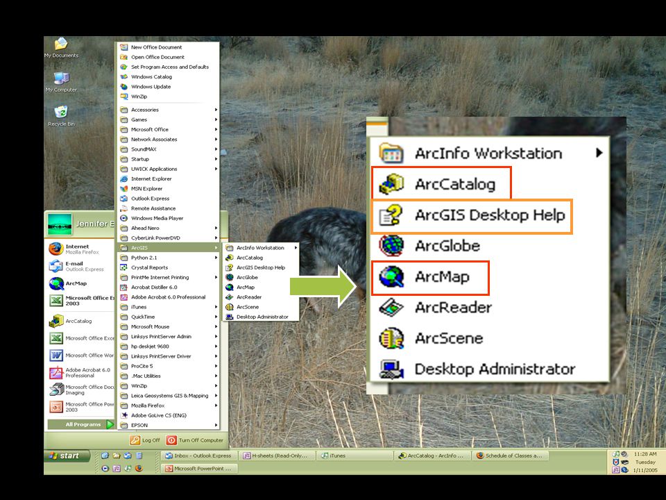
How a GIS works Introduction to ArcGIS The ArcGIS Interface

31
ArcMap – viewing, editing, processing…..

32
The ArcGIS Interface ArcCatalog – Data Management Editing Processing

33
The ArcMap Interface table of contents map display GUI data frame layer scale

34
Toolbars demonstration of help tips

35
The ArcCatalog Interface GUI catalog tree catalog view folders data sources

36
The ArcCatalog Interface contents mode

37
The ArcCatalog Interface Preview geography mode

38
The ArcCatalog Interface preview table mode

39
The ArcCatalog Interface metadata mode

40
ArcToolbox & Geoprocessing Most geoprocessing tasks are accessed through ArcToolbox

41
ArcToolbox & Geoprocessing ArcToolbox can be “docked” in ArcMap or ArcCatalog

42
ArcToolbox & Geoprocessing Geoprocessing tasks can also be performed using the command line

43
ArcScene Application for viewing data in 3 dimensions in “real time”

44
ArcGlobe Application for viewing global data in 3 dimensions in “real time”

45
Homework Read: “What is ArcGIS9” “Exploring the ArcGIS interface” “ArcGIS GUI” “ArcGIS modules” Post a message to E-post with: Your year (fr,so,jr,sr,etc) Your major Why you are taking the course Do: Assignment 1 and submit with E-submit Check E-post regularly
 Your major Why you are taking the course Do: Assignment 1 and submit with E-submit Check E-post regularly")
Similar presentations


 Zeng January 19, 2011.>")


