Download presentation
Presentation is loading. Please wait.

1
Rivers

2
Long Profile Height above sea level in meters. 0 50 100 150 200 250
Gradient/slope decreasing Distance from sea in Kms. Source. Upland stream. Lowland river. Mouth. Velocity/flow increasing Cumecs/discharge increasing Energy increases

3
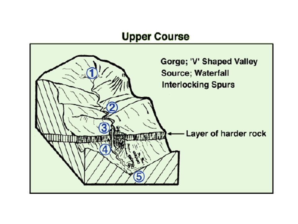
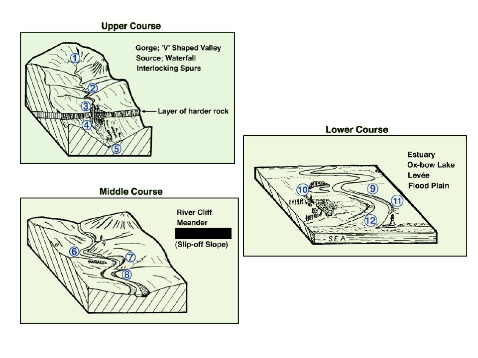
Upper course

5
Erosion Processes Corrosion - Attrition - Abrasion (Corrasion) - Hydraulic Action - is when the river is loaded with material in suspension and scours away at the river banks. (Sandpaper effect) is the shear force of the river impacting on the sides of the river banks. is substances carried in solution such as acids. They dissolve rocks away over long periods of time. is when bed load collides into each other with the current flow and breaks down into smaller particles.
 is the shear force of the river impacting on the sides of the river banks. is substances carried in solution such as acids. They dissolve rocks away over long periods of time. is when bed load collides into each other with the current flow and breaks down into smaller particles.")
6
Waterfall formation Look at the diagram, How is a waterfall formed?

7
High Force Waterfall R. Tees

9
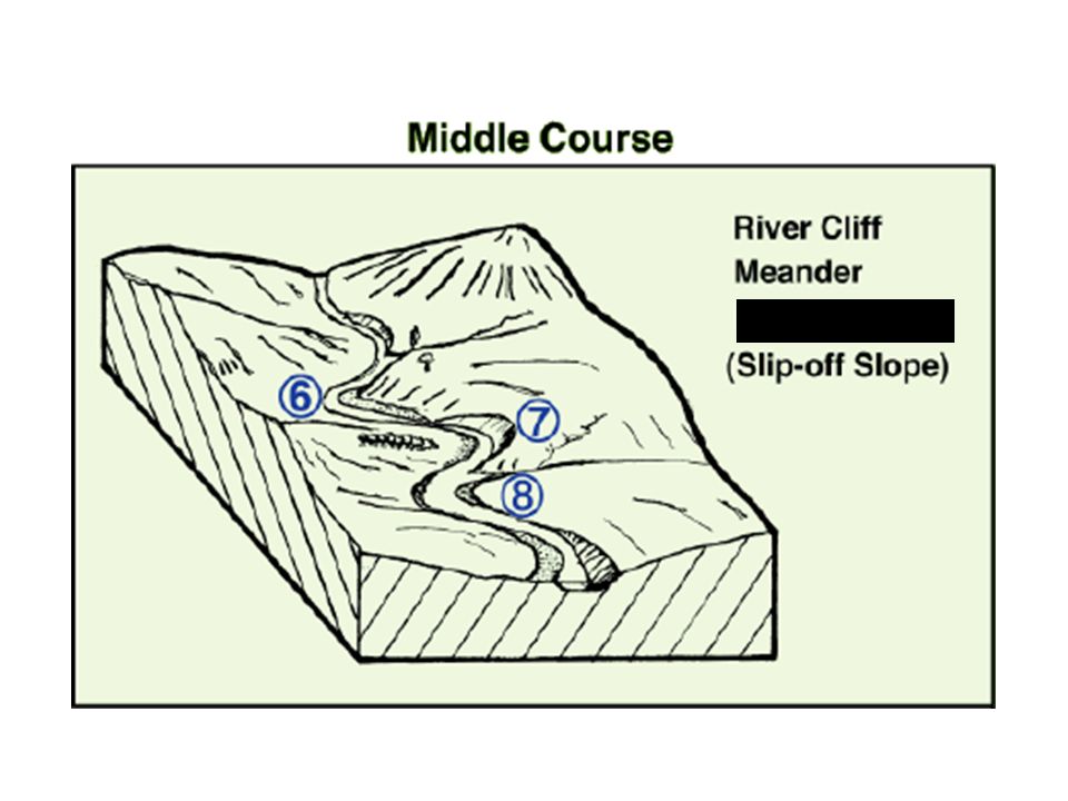
Middle course, R. Tees HOW DOES THIS DIFFER FROM THE UPPER SECTION?

10
Middle course, R. Tees WHAT DO YOU THINK THE ARROWS POINT TO?
Valley opens out, more gentle slopes, wider valley bottom First signs of meanders River channel wider, deeper, greater velocity and discharge

11
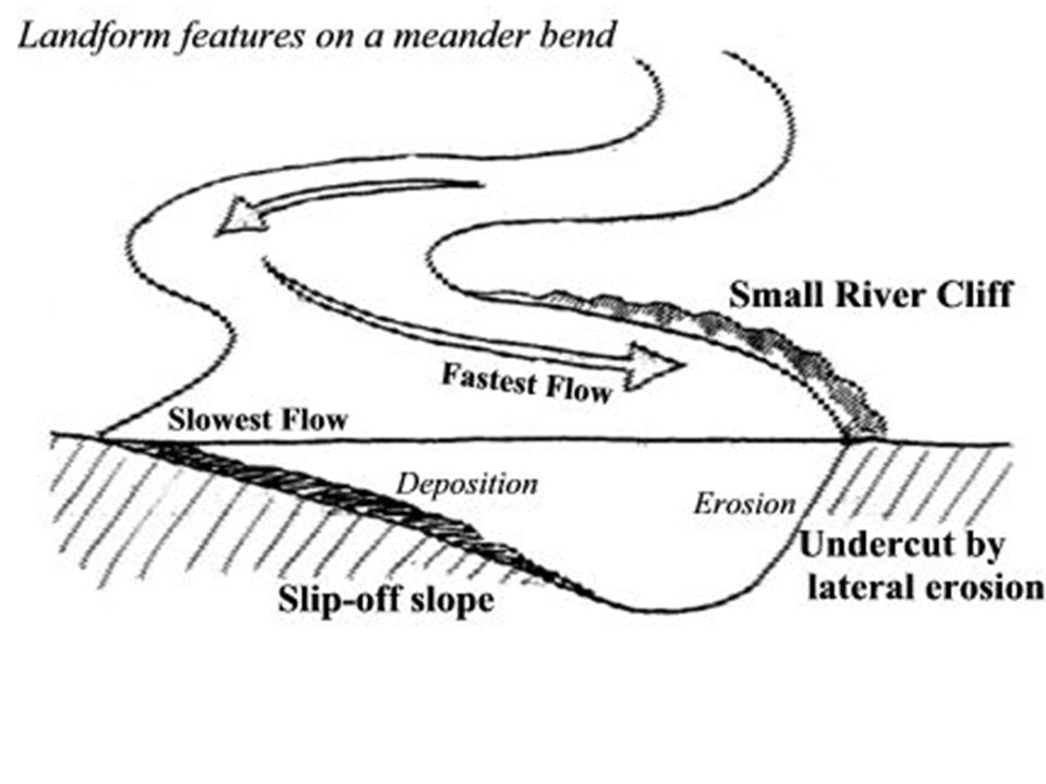
Meandering Rivers WHAT IS A MEANDER?

12
Formation of Meanders

13
Point bar deposits

15
3 2 Match the feature/process to the correct definition. Add the number of the arrow alongside each feature / process. 4 1 5 Deep water A gently sloping area of land on the inside of a meander Slip off slope Formed on the outside bend of the meander due to erosion. River cliff Because of the gentle slope, there is a lot of frictional drag and so therefore the river flows at this speed Fastest flow Maximum depth of the channel. (Note the asymmetrical cross-profile) Slowest flow There is little frictional drag from the bed and bank at this point and so the river can flow at this speed.
 Slowest flow. There is little frictional drag from the bed and bank at this point and so the river can flow at this speed.")
17
Point Bar Deposits Point bar deposits grows laterally through time

19
Meander, R. Lavant, Chichester

20
Meander, R. Lavant, Chichester
WHAT DO THE ARROWS POINT TO? WHICH WAY IS THIS MEANDER MOVING? Floodplain Slip-Off Slope River Cliff Point bar deposits on the inner meander bend where there is low energy

21
} Cut bank erosion (River Cliff) Point bar deposits Meander loop
WHERE IS EROSION TAKING PLACE? Cut bank erosion (River Cliff) F A E B Point bar deposits } Meander loop C D WHERE IS DEPOSTION TAKING PLACE?
 F. A. E. B. Point bar deposits. } Meander loop. C. D. WHERE IS DEPOSTION TAKING PLACE")
22
Meander on the R. Colorado
WHY IS DEPOSITION OCCURING HERE?

23
How did these meanders form?

25
REVISION: What River features do you get here?

26
Migrating meanders, R. Gongola, Nigeria
WHY ARE THEY MIGRATING?

27
What happens to the river when it moves to the middles course
Gradient becomes less steep River continues to erode vertically but LATERAL erosion now occurs in MEANDERS What is MEANDER MIGRATION ? Name three effects it have on the valley? What factors effect how much load is being carried?

28
Key words - Transportation.
Traction – where large rocks and boulders are rolled along the river bed. Saltation – where smaller stones are bounced along the river bed in a leap frogging motion Suspension – where very small grains of sand or silt are carried along with the water Solution – where some material is dissolved (like sugar in a cup of tea) and is carried downstream.
 and is carried downstream.")
29
Traction Heavy rocks and boulders are rolled along the river bed. Happens most in times of flood, when the current is strongest.

30
Saltation. Small stones and pebbles are ‘bounced’ along the river bed. Saltation can take place when the river flow is less than that needed for ‘Traction’ to take place.

31
Suspension Very small particles of sand or clay that are ‘suspended’ in the water. These particles will ‘settle’ if kept in a jar of water overnight and the water will look clear.

32
Solution. Takes place when material is dissolved in the water, it is invisible and does not colour the water. Occurs often in limestone landscapes where the water if very acidic. Some pollutants like weedkiller are also held in solution in the water

33
Methods of transport Copy this picture into your books and add the title above and labels for each type of transport Shows the rate of flow needed Traction Saltation Suspension Solution

35
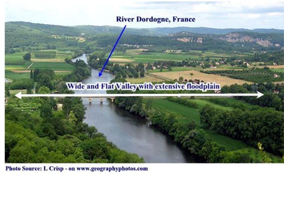
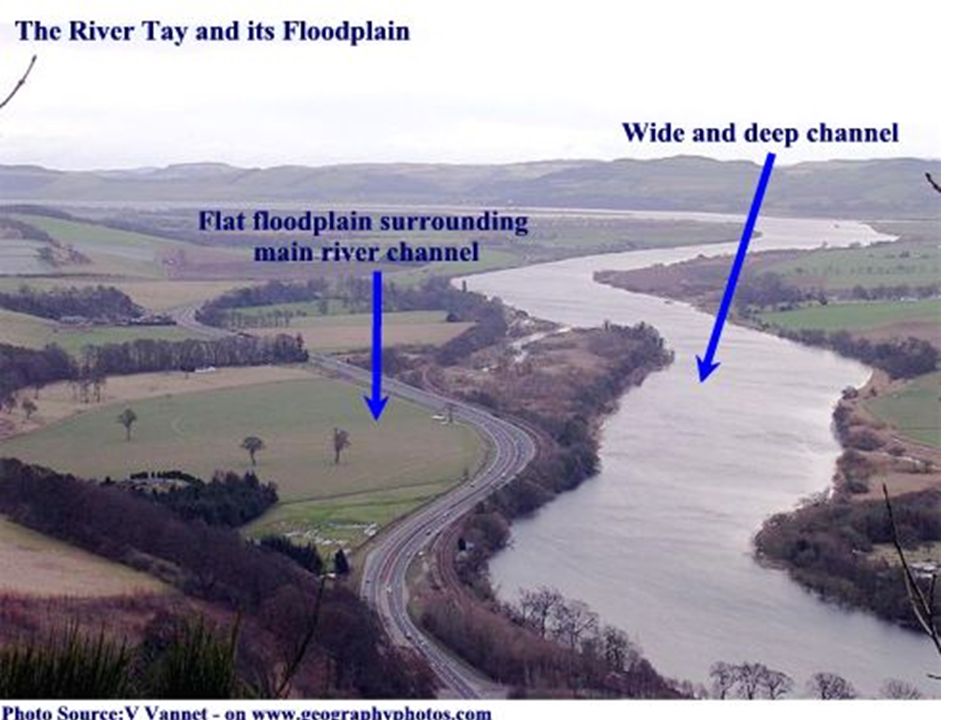
Lower Course: Severn Valley

37
Lower Severn Valley Very wide floodplain Well developed meanders with bars in the channel indicating high sediment load Very gentle valley side gradients HOW DOES IT DIFFER FROM THE MIDDLE COURSE?

38
Flood Plains HOW DO YOU THINK THE TERRACES WERE FORMED? The entire floodplain can become covered with water during floods.

41
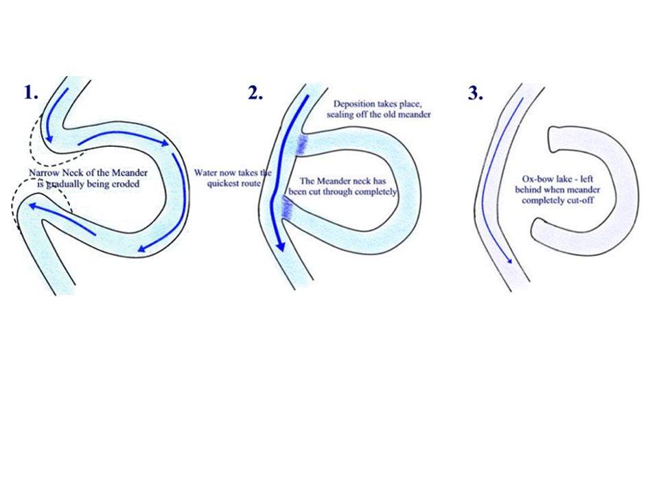
Ox Bow Lake Formation LOOK AT THE DIAGRAM & EXPLAIN THERE FORMATION

43
Formation of an Oxbow

44
Ox Bow lake on Mississippi

45
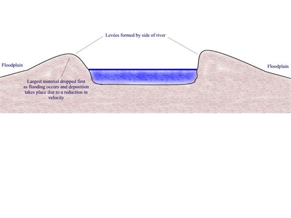
Levee formation

46
Levees WHAT DO YOU THING HUMANS MIGHT HAVE DONE TO THIS LEVEE?

47
Delta Formation WHAT IS A DELTA? DEPOSITON OF MATERIAL BY THE RIVER
WHEN IT ENTERS THE SEA WHY DOES IT DROP ITS SEDIMENT

48
Mississippi Delta from Space

49
The Nile Delta from space
River Nile

50
Estuary Formation HOW DOES THIS DIFFER FROM A DELTA? The Lower Course of a river valley has been DROWNED by a rise in sea level or a fall in the land level. RAISED VALLEY SIDES USING YOUR ATLAS FIND AN ESTUARY (LOOK AT THE RIVER THAMES)
")
51
The Rhone Delta USING YOU ATLAS LOCATE THE RHONE DELTA

52
The Rhone Delta S. France
Look at p39 and identify the KEY FEATURES CAN YOU SEE IN THE SATELLITE PHOTO?

53
The Rhone Delta WHY HAS A DELTA FORMED HERE? LOOK AT P 39

55
Summary of valley characteristics

57
Lower Course: Severn Valley

58
Lower Severn Valley Very wide floodplain Well developed meanders with bars in the channel indicating high sediment load Very gentle valley side gradients HOW DOES IT DIFFER FROM THE MIDDLE COURSE?

59
Flood Plains HOW DO YOU THINK THE TERRACES WERE FORMED? The entire floodplain can become covered with water during floods.

60
Ox Bow Lake Formation LOOK AT THE DIAGRAM & EXPLAIN THERE FORMATION

61
Formation of an Oxbow

62
Ox Bow lake on Mississippi

63
Levee formation

64
Levees WHAT DO YOU THING HUMANS MIGHT HAVE DONE TO THIS LEVEE?

65
Delta Formation WHAT IS A DELTA? DEPOSITON OF MATERIAL BY THE RIVER
WHEN IT ENTERS THE SEA WHY DOES IT DROP ITS SEDIMENT

66
Mississippi Delta from Space

67
The Nile Delta from space
River Nile

68
Estuary Formation HOW DOES THIS DIFFER FROM A DELTA? The Lower Course of a river valley has been DROWNED by a rise in sea level or a fall in the land level. RAISED VALLEY SIDES USING YOUR ATLAS FIND AN ESTUARY (LOOK AT THE RIVER THAMES)
")
69
The Rhone Delta USING YOU ATLAS LOCATE THE RHONE DELTA

70
The Rhone Delta S. France
Look at p39 and identify the KEY FEATURES CAN YOU SEE IN THE SATELLITE PHOTO?

71
The Rhone Delta WHY HAS A DELTA FORMED HERE? LOOK AT P 39

73
Summary of valley characteristics

Similar presentations


 _________ 3) _________>")


