Download presentation
Presentation is loading. Please wait.

1
Surface Water Streams and Rivers Stream Erosion and Deposition
River Valleys Flood Plains and Floods

2
Tigris – Euphrates River
River that was a boundary of Mesopotamia, or the "land between the rivers" (Tigris and Euphrates) The Tigris was the eastern of the two rivers and flowed from a source deep in the Armenian mountains all the way to the Persian Gulf, about 1,200 miles. Both rivers were the lifeblood of Mesopotamian civilizations, giving them water and a vehicle for their trade and defense.
 The Tigris was the eastern of the two rivers and flowed from a source deep in the Armenian mountains all the way to the Persian Gulf, about 1,200 miles. Both rivers were the lifeblood of Mesopotamian civilizations, giving them water and a vehicle for their trade and defense.")
3
The Nile River The Nile River is actually 6695 kilometers (4184 miles) long. With such a long length, the Nile River is speculated to be the longest river in the world. The Amazon River runs a very close second, although it has been difficult to determine which is actually longer. River Nile facts state it winds from Uganda to Ethiopia, flowing through a total of nine countries. While the Nile River is often associated with Egypt, it actually touches Ethiopia, Zaire, Kenya, Uganda, Tanzania, Rwanda, Burundi and Sudan, as well as Egypt. It's only recent that the first known navigation team successfully followed the river from beginning to its end.
 long. With such a long length, the Nile River is speculated to be the longest river in the world. The Amazon River runs a very close second, although it has been difficult to determine which is actually longer. River Nile facts state it winds from Uganda to Ethiopia, flowing through a total of nine countries. While the Nile River is often associated with Egypt, it actually touches Ethiopia, Zaire, Kenya, Uganda, Tanzania, Rwanda, Burundi and Sudan, as well as Egypt. It s only recent that the first known navigation team successfully followed the river from beginning to its end.")
4
Yangtze River The Yangtze River (Changjiang), over 6,300 kilometers long, is the largest and longest river in China, and the third-longest in the world, next only to the Nile in northeast Africa and the Amazon in South America. The source of the Yangtze River lies to the west of Geladandong Mountain, the principal peak of the Tanggula Mountain chain in the Qinghai-Tibetan Plateau, southwest of China. The river flows from west to east through provinces of Qinghai, Tibet, Sichuan, Yunnan, Sichuan, Hubei, Hunan, Jiangxi, Anhui and Jiangsu as well as the city of Shanghai, finally emptying into the East China Sea. With plenty of rainfall all year round, the Yangtze River is named the golden watercourse.
, over 6,300 kilometers long, is the largest and longest river in China, and the third-longest in the world, next only to the Nile in northeast Africa and the Amazon in South America. The source of the Yangtze River lies to the west of Geladandong Mountain, the principal peak of the Tanggula Mountain chain in the Qinghai-Tibetan Plateau, southwest of China. The river flows from west to east through provinces of Qinghai, Tibet, Sichuan, Yunnan, Sichuan, Hubei, Hunan, Jiangxi, Anhui and Jiangsu as well as the city of Shanghai, finally emptying into the East China Sea. With plenty of rainfall all year round, the Yangtze River is named the golden watercourse.")
5
Ganges River Ganges River, Hindi Ganga, great river of the plains of northern India. Although officially as well as popularly called the Ganga in Hindi and in other Indian languages, internationally it is known by its conventional name, the Ganges. From time immemorial it has been the holy river of Hinduism. For most of its course it is a wide and sluggish stream, flowing through one of the most fertile and densely populated regions in the world. Despite its importance, its length of 1,560 miles (2,510 km) is relatively short compared with the other great rivers of Asia or of the world. Rising in the Himalayas and emptying into the Bay of Bengal, it drains a quarter of the territory of India, while its basin supports hundreds of millions of people. The Gangetic Plain, across which it flows, is the heartland of the region known as Hindustan and has been the cradle of successive civilizations from the Mauryan empire of Ashoka in the 3rd century bce down to the Mughal Empire, founded in the 16th century.
 is relatively short compared with the other great rivers of Asia or of the world. Rising in the Himalayas and emptying into the Bay of Bengal, it drains a quarter of the territory of India, while its basin supports hundreds of millions of people. The Gangetic Plain, across which it flows, is the heartland of the region known as Hindustan and has been the cradle of successive civilizations from the Mauryan empire of Ashoka in the 3rd century bce down to the Mughal Empire, founded in the 16th century.")
6
Amazon River The Amazon is the greatest river in the world by so many measures; the volume of water it carries to the sea (approximately 20% of all the freshwater discharge into the oceans), the area of land that drains into it, and its length and width. It is one of the longest rivers in the world and, depending upon who you talk to, is anywhere between 6,259km/3,903mi and 6,712km/4,195mi long. For the last century the length of the Amazon and the Nile Rivers have been in a tight battle for title of world's longest river. The exact length of the two rivers varies over time and reputable sources disagree as to their actual length. The Nile River in Africa is reported to be anywhere from at 5,499km/3,437mi to 6,690km/4,180mi long. But there is no question as to which of the two great rivers carries the greater volume of water - the Amazon River.
, the area of land that drains into it, and its length and width. It is one of the longest rivers in the world and, depending upon who you talk to, is anywhere between 6,259km/3,903mi and 6,712km/4,195mi long. For the last century the length of the Amazon and the Nile Rivers have been in a tight battle for title of world s longest river. The exact length of the two rivers varies over time and reputable sources disagree as to their actual length. The Nile River in Africa is reported to be anywhere from at 5,499km/3,437mi to 6,690km/4,180mi long. But there is no question as to which of the two great rivers carries the greater volume of water - the Amazon River.")
7
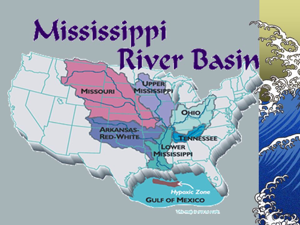
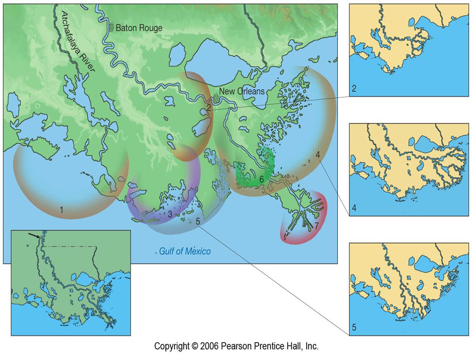
The Mississippi River The Mississippi and its tributaries drain almost all the plains between the Appalachian Mountains and the Rocky Mountains. Its drainage basin is the third largest in the world, exceeded in size only by the watersheds of the Amazon and Congo Rivers. The drainage basin covers 1,247,300 square miles (3,230,490 square kilometers) in 31 states and 2 Canadian provinces. This area encompasses the nation's most productive agricultural and industrial regions. The Mississippi is the nation's chief navigable water route.
 in 31 states and 2 Canadian provinces. This area encompasses the nation s most productive agricultural and industrial regions. The Mississippi is the nation s chief navigable water route.")
9
Water Phase Changes To view this animation, click “View” and then “Slide Show” on the top navigation bar.

10
Hydrologic Cycle To view this animation, click “View” and then “Slide Show” on the top navigation bar.

13
Streams and Rivers Surface Water
A river system consists of a river and all of its tributaries. VOCABULARY tributary Tributary River Divide river system drainage basin watershed divide gradient discharge Stream Systems A stream is a body of water that carries rock particles and dissolved ions and flows down slope along a clearly defined path, called a channel. Thus streams may vary in width from a few centimeters to several kilometers. Streams are important for several reasons Streams carry most of the water that goes from the land to the sea, and thus are an important part of the water cycle. Streams carry billions of tons of sediment to lower elevations, and thus are one of the main transporting mediums in the production of sedimentary rocks. Streams carry dissolved ions, the products of chemical weathering, into the oceans and thus make the sea salty. Streams are a major part of the erosional process, working in conjunction with weathering and mass wasting. Much of the surface landscape is controlled by stream erosion, evident to anyone looking out of an airplane window. Streams are a major source of water and transportation for the world's human population. Most population centers are located next to streams. The drainage basin of a river system is all the land that is drained by the river and its tributaries. A river’s velocity, gradient, discharge, and channel shape affect how it erodes and transports materials.

14
Important Definitions
____________ – a stream and all its tributaries ________ – a smaller stream that empties into a larger stream _________ – the land area drained by a river system ______ – a high point that separates river systems River System Tributary Watershed Divide

15
River Channels and Drainage
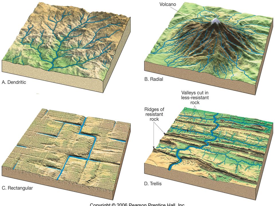
There are different types of river channel patterns and river drainage patterns. Dendritic Radial Rectangular Trellis

17
Dendritic network A drainage network whose interconnecting streams resemble the pattern of branches connecting to a deciduous tree

18
radial network A drainage network in which the streams flow outward from a cone-shaped mountain, and define a pattern resembling spokes on a wheel. Radial network A drainage network in which the streams flow outward from a cone-shaped mountain, and define a pattern resembling spokes on a wheel.

19
Rectangular network A drainage network in which the streams join each other at right angles because of a rectangular grid of fractures that breaks up the ground and localizes channels. rectangular network A drainage network in which the streams join each other at right angles because of a rectangular grid of fractures that breaks up the ground and localizes channels.

20
Trellis network A drainage system that develops across a landscape of parallel valleys and ridges so that major tributaries flow down the valleys and join a trunk stream that cuts through the ridge; the resulting map pattern resembles a garden trellis. trellis network A drainage system that develops across a landscape of parallel valleys and ridges so that major tributaries flow down the valleys and join a trunk stream that cuts through the ridge; the resulting map pattern resembles a garden trellis.

21
Stream Erosion and Deposition
Surface Water Stream Erosion and Deposition VOCABULARY Rivers wear down Earth’s surface and erode and deposit materials. A river may carry materials in solution, in suspension, and in its bed load. deposition pothole load suspension bed load Flow Suspension: Silt and clay Bed load: sand, gravel, pebbles and boulders Materials carried in solution cannot be seen. competence capacity delta

22
Stream Load A stream can carry its load in three different ways:
1.________ – material is dissolved 2.__________ – particles are held up by stream’s moving water 3._________ – material pushed or rolled along the stream’s channel solution suspension bed load

23
How Streams Move Sediment
To view this animation, click “View” and then “Slide Show” on the top navigation bar.

24
Stream Erosion and Deposition
Surface Water Stream Erosion and Deposition Velocity and discharge affect how much material a river can transport. When river velocity greatly decreases, sediment drops out of the water to form a delta or alluvial fan. Over time, sediments build up, forming a delta.

25
Stream Discharge Discharge is the amount of water that flows past a point in a certain amount of time. Discharge is dependent upon velocity, depth, and width of the stream. Discharge = _______ x _____ x _____ velocity depth width

27
Vocabulary Summary deposition pothole load capacity delta
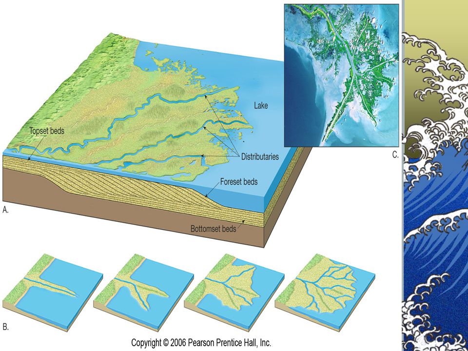
A process by which materials is dropped, such as sand or silt by a stream; Deep oval or circular basins cut into a stream or river bed by abrasion from swirling sand, pebbles, and small boulders. The eroded rock and soil materials that are transported downstream by a river. A measure that describes the maximum size of the particles a stream can carry. A fan-shaped deposit that forms when a river flows into a quiet or large body of water, such as a lake, an ocean, or an inland sea.

28
RIVER DEPOSITION A river drops some of its load when either its volume or its speed decreases eg when it enters an arid (dry) region, crosses an area of porous rock (eg limestone), enters a flat or gently sloping plain or enters a lake or the sea. Material transported or deposited by a river is called alluvium.
 region, crosses an area of porous rock (eg limestone), enters a flat or gently sloping plain or enters a lake or the sea. Material transported or deposited by a river is called alluvium.")
29
Alluvial Fan ____________ – deposit formed when a stream spreads out onto a less steep area

30
_____ – where a stream empties into a larger body of water
Delta _____ – where a stream empties into a larger body of water

33
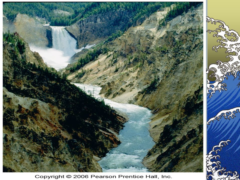
Stream Stages Youthful Old Rapids Waterfalls Fast-moving water
________: Rapids Waterfalls Fast-moving water Steep slope _______: Broad floodplain Meanders Oxbow lakes Meander Scars

34
River Systems Youthful Mature Old

35
Stream Processes and Floodplain Development
To view this animation, click “View” and then “Slide Show” on the top navigation bar.

36
River Valleys Surface Water
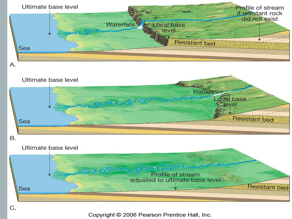
Youthful rivers form steep-sided canyons and V-shaped valleys. The lowest level to which a river can erode its bed is called its base level. Rapids can form as a river runs down a deep slope, while a river that plunges over a cliff forms a waterfall.

37
River Valley Terms Headward erosion Base level Stream piracy
The process by which land is worn away at the head of gully or stream valley. The level of the body of water into which a stream flows. The diversion of the upper part of one stream by the headward growth of another stream.

38
____________ – when an old age stream downcuts to “make it new again”
Rejuvenation ____________ – when an old age stream downcuts to “make it new again”

40
Forming Stream Terraces
To view this animation, click “View” and then “Slide Show” on the top navigation bar.

41
Floodplains and Floods
Surface Water Floodplains and Floods VOCABULARY A river that has cut down close to its base level tends to erode the sides of its valley, forming a meandering river in a wide flood plain. flood floodplain meanders oxbow lake natural levees Valley wall Back swamp flash flood Oxbow lake floodplain Meander Natural levees Yazoo tributary

42
________ – the bends and curves of a stream
Meanders ________ – the bends and curves of a stream

43
Oxbow lake deposition erosion

44
Oxbow Lakes To view this animation, click “View” and then “Slide Show” on the top navigation bar.

45
Oxbow Lakes To view this animation, click “View” and then “Slide Show” on the top navigation bar.

46
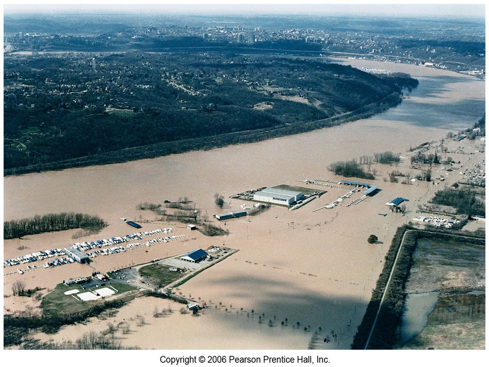
Floodplains and Floods
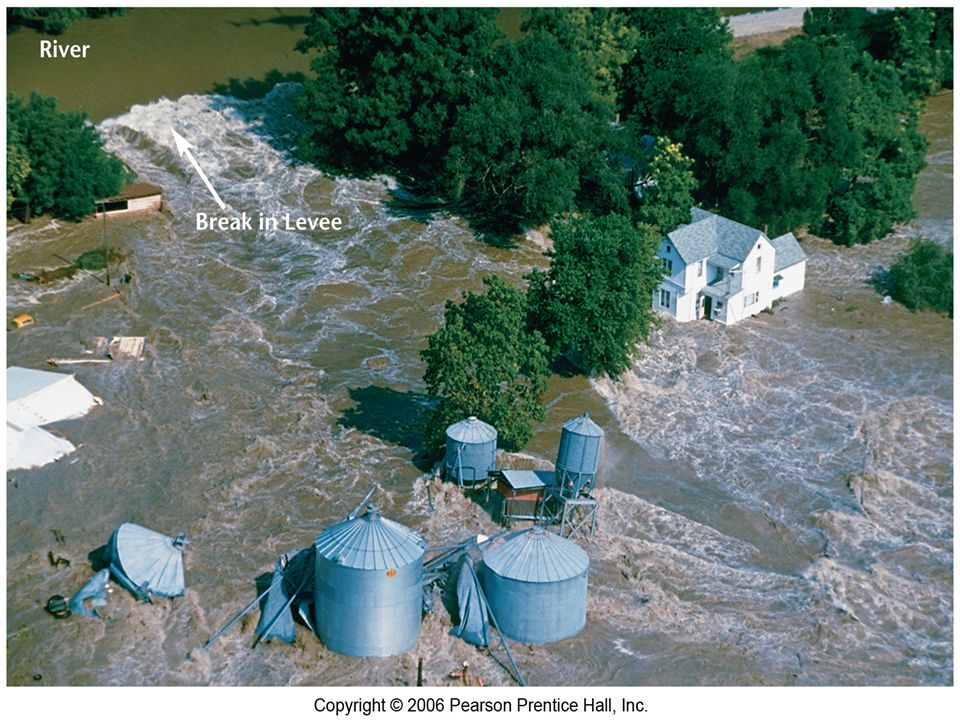
Surface Water Floodplains and Floods River floods are natural events that can have constructive as well as destructive effects. People have developed different methods to control and prevent river flooding.

47
Floodplain and Natural Levee Development
To view this animation, click “View” and then “Slide Show” on the top navigation bar.

48
Mississippi River Flood
1993 Before and After

51
Vocabulary Review Flood: The phenomenon whereby a river overflows its banks. Flood plain: A wide, level area that borders a river and is covered by its water during a flood. Meander: Broad: looping bends in a river. Oxbow lake: A crescent-shaped body of water formed when sediments deposited by a river cut off a meander from the river. Natural levees: Elevated ridges along a river’s bank that are formed by the deposition of the river’s sediment load. Flash flood: A sudden flood, usually caused by intense, heavy rainfall.

Similar presentations


 and rivers that flow down hill therefore changing.>")

