Download presentation
Presentation is loading. Please wait.

1
WHAT CAN YOU REMEMBER? ocean land 2) _________ 3) _________
4) _________ 1) ________ 5) __________ 6) ________ ocean land
 _________. 1) ________. 5) __________. 6) ________. ocean. land.")
2
WHAT CAN YOU REMEMBER? ocean land condensation precipitation
transpiration evaporation surface runoff ground water ocean land

3
PHYSICAL LANDSCAPES INTRODUCING RIVERS

4
WHAT ARE WE GOING TO LEARN?
What is a drainage basin? Why is a drainage basin like a kitchen sink? What are the four processes of erosion in rivers? What are the four processes of transportation in rivers?

5
THE DRAINAGE BASIN Dyfi
A drainage basin is an area of land that is drained by a river and its tributaries. DRAINAGE BASIN

6
THE DRAINAGE BASIN WATERSHED Nature’s ‘kitchen sink’
The higher land that forms the edge, or boundary, of a drainage basin is called the watershed. Nature’s ‘kitchen sink’ WATERSHED

7
Drainage basins act like nature’s kitchen sinks.
THE DRAINAGE BASIN All the rain that falls within a drainage basin flows into a single river channel that flows to the sea (or lake). Drainage basins act like nature’s kitchen sinks.
. Drainage basins act like nature’s kitchen sinks.")
9
River Basin Features Watershed the area of high land forming the edge of a river basin. Source where a river begins. Mouth where a river meets the sea. Confluence the point at which two rivers meet. Tributary a small river or stream that joins a larger river. Channel this is where the river flows. Drainage Basin this is the area of land drained by a river and its tributaries.

10
DRAINAGE BASIN TERMS SOURCE TRIBUTARY CONFLUENCE CHANNEL MOUTH

11
PHYSICAL LANDSCAPES THE RIVER COURSE

12
THE RIVER COURSE UPPER COURSE MIDDLE COURSE LOWER COURSE

13
RIVER PROCESSES Rivers play a big role in shaping our landscape.
They are able to do this because they have energy. This means that they can do work. The work they do is erosion and transportation. When they run out of energy they have to stop doing work, so they drop what they are carrying. This is called deposition.

14
EROSION PROCESSES Erosion is the wearing away of the river bed, river
There are four processes of river erosion: attrition corrasion corrosion hydraulic action

15
TRANSPORTATION PROCESSES
There are four processes of transportation: traction saltation suspension solution

16
TRANSPORTATION PROCESSES
Solution Suspension Saltation Traction

17
RIVER EROSION

18
THE SOURCE The source is the start or beginning of a river.
The source of a river is usually found in the hills or mountains.

19
Water can sink through gaps in the rocks
SPRINGS rain Water can sink through gaps in the rocks Underground water emerges where the rock type changes Permeable rock ie Limestone Rocks are saturated Impermeable rock ie Clay Spring

20
THE RIVER COURSE UPPER COURSE MIDDLE COURSE LOWER COURSE

21
UPPER COURSE CHARACTERISTICS
steep valley sides steep channel gradient narrow valley floor narrow, shallow channel

22
Upper Course Characteristics large, angular stones and boulders

23
UPPER COURSE CHARACTERISTICS
turbulent river flow at a section of rapids

24
Upper Course Landforms
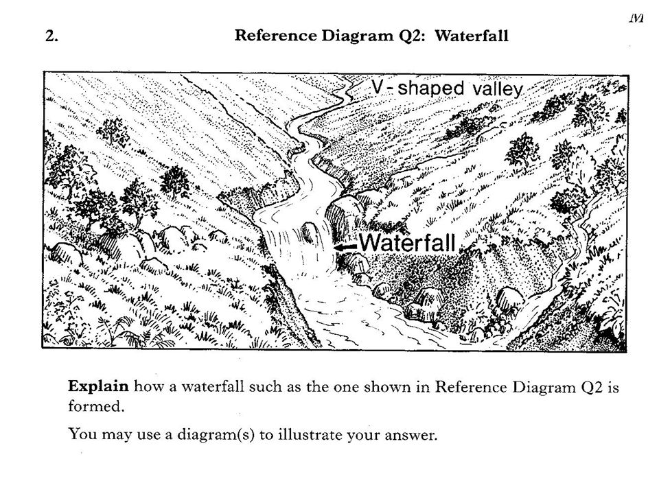
a typical V-shaped valley

25
Key Features: V-shaped valley A steep sided and narrow valley that is formed due to vertical erosion. The load of the river cuts downwards and deepens the bed of the river.

26
Upper Course Landforms
a typical V-shaped valley

27
Upper Course Landforms
interlocking spurs interlocking spurs

28
Upper Course Landforms
interlocking spurs interlocking spurs

29
Angel Falls, Venezuela

30
Hopetoun Falls, Australia

31
Victoria Falls, Zambia/Zimbabwe

32
Jog Falls, India

33
Niagara Falls, Canada/USA

38
WATERFALL RETREATS . . UPSTREAM . . OVERHANG PLUNGE POOL UNDERCUTTING OF SOFT ROCK

39
Upper Course Landforms
interlocking spurs interlocking spurs

40
Rapids A series of gentle breaks in the slope of a river bed due to different types of rock.

41
Hydro-electric power

42
River Model Upper Course Middle Course Lower Course

43
S3 Rivers: The Middle Course

44
At the middle stage of the river the valley sides become less steep
The river is now wider and deeper It does not flow at the same speed throughout its middle course, some parts are slower, some are faster

45
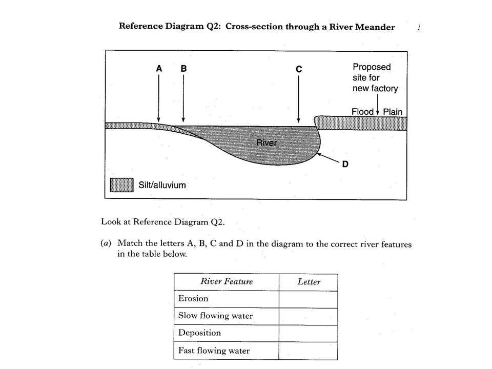
Meander ( = bend in a river’s channel)
")
46
What do you notice about the bank of the river channel on the outside of the bend?

47
Which is the fastest side of a river?

49
Why do rivers meander (bend)?
Copy the diagram above and put the following labels in the correct place: Deposition Fast flow of river Shallow water River Cliff Lateral Erosion Slow flow of river Deeper water River beach (Slip-off slope) 2. Describe why one side of the river bend is different from the other.
 2. Describe why one side of the river bend is different from the other.")
51
S3 Rivers: The Lower Course

52
The river is closest to its mouth
At its lower stage, the river is in a wide flat valley with gentle valley sides The river is closest to its mouth

53
E A F B C D

54
Ox-bow Lakes

55
The river erodes the outside of the bend and deposits on the inside so its course is changing. This erosion narrows the neck of the meander. Often during a flood the river will cut through the neck. The river continues in the new bed and the meander is abandoned. New deposition seals off the ends and the cut-off becomes an ox-bow lake.

56
Ox-bow lake on Mississippi

57
Levee formation

58
Built-up levees

59
1. When a river with a very low gradient floods a lot of silt is deposited on the river banks and much less on the flood plain. 2. Frequent flooding continues this build up of silt. When the river is flowing normally it deposits in the river bed. 3. This raises the river above the flood plain but, usually the built up levées protect the plain from flooding.

Similar presentations