Download presentation
Presentation is loading. Please wait.

1
Human Geography It’s Nature and Perspectives

2
what is geography? Essential Questions: How can geography be used to shape our view of the world? Learning Target: IWBAT explain the importance of geography as a field of study Formative Assessment(s): We use GPS on a daily basis. How does using GPS cause you to look at the world differently?
: We use GPS on a daily basis. How does using GPS cause you to look at the world differently .")
3
Bellwork How do you use geography on a daily basis?

4
what is geography? “description of the earth” a study of spatial variation –the how and why of physical & cultural differences –location, location, location –observable patterns that have evolved through time

5
- interaction of physical environment and human activity (Marsh, Sauer) - cultural landscape can alter the natural environment
 - cultural landscape can alter the natural environment")
6
evolution of the discipline - mapping/human interpretation Aristotle (384-322 BC) Erathosthenes (276 BC) Strabos (63BC-24AD)/Herodotus (484- 423BC)
 Erathosthenes (276 BC) Strabos (63BC-24AD)/Herodotus ( BC)")
7
Ptolemy (2 nd century AD)
")
8
outside the western world Chinese Scholars Muslim Scholars

9
human geography Where are people? What are they like? What is their interaction over space? What kinds of landscapes do they erect?

10
physical geography attention towards natural landscape –landforms and their distribution –atmospheric conditions and climatic patterns –soils / vegetation associations

11
modern geography….. 1. Climates, patterns, processes of physical environment 2. Rapid development of natural sciences 3. Accurate mapping 4. Data collection / statistics

12
academic geography Earth science Man-land relations Areal differentiation Spatial organization –location –processes –patterns –interactions/relations –distributions

13
Formative Assessment We use GPS on a daily basis. How does using GPS cause you to look at the world differently?

14
what is geography? Essential Questions: How can geography be used to shape our view of the world? Learning Target: IWBAT use and understand maps. Formative Assessment(s): Give an definition of absolute location and relative location. Give an example of each.
: Give an definition of absolute location and relative location. Give an example of each..")
15
Bellwork What labels are important to include on a map?

16
three concepts about space Location Direction Distance

17
absolute location Mathematical location –Latitude & Longitude degrees, minutes, seconds –Township & Range (1785 Land Ordinance) Subdivision: parallels & meridians Topographic quadrangle, US Geological Survey –Metes & Bounds
 Subdivision: parallels & meridians Topographic quadrangle, US Geological Survey –Metes & Bounds")
18
latitude & longitude (22° 15' N, 114° 10‘ E)
")
19
relative location “place” in relationship to surroundings

20
Site –absolute location concept –physical & cultural characteristics Topography, vegetation, water, physical characteristic

21
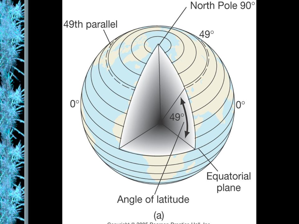
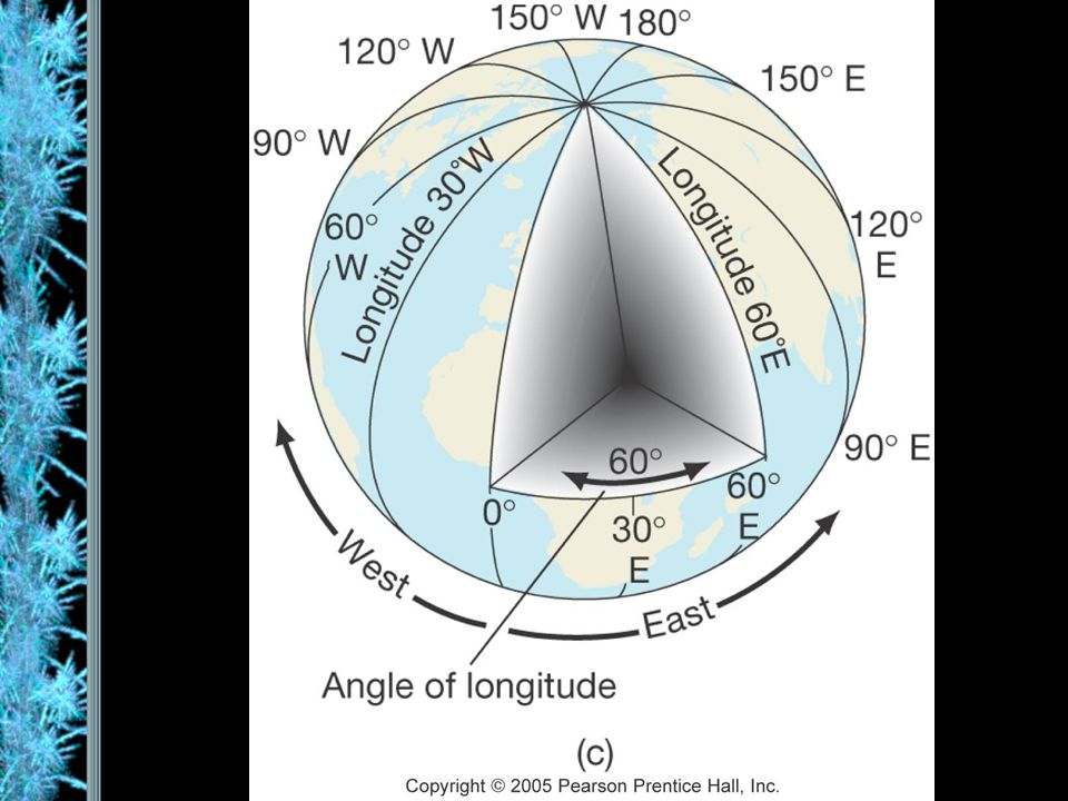
Situation –external relations of locale –relative location concept –dynamic

22
absolute directions Based on cardinal systems –north, south, east, west –from solar system

23
relative directions Based on cultural & local perceptions –no absolute boundaries or definitions –“down south”, “out west”, “up north”, “down south”, “Near East”, “Far East” –Left, right, forward, backward

24
absolute distance Absolute mathematical mileage, or measurement of distance

25
relative distance Refers to a more regional spatial relationship –how distance is described MILES MINUTES $$$ & TIME

26
psychological distance Distance lengthened / shortened –first time traveled –night / day travel –safety / danger / excitement

27
size & scale Size of unit studied Scale implies degree of generalization –broad or narrow –Varying sizes local regional global

28
Formative Assessment(s) Give a definition of absolute location and relative location. Give an example of each.

29
what is geography? Essential Questions: How can geography be used to shape our view of the world? Learning Target: IWBAT define regions and evaluate the regionalization process Formative Assessment(s): Give a definition of formal, functional, and perceptual regions. Give an example of each.
: Give a definition of formal, functional, and perceptual regions. Give an example of each..")
30
Bellwork Answer the questions below: Where do your clothes come from? Where do your cell phones come from? Where does your food come from? Where do your shoes come from?

31
landscapes Natural Cultural Dynamic

32
multi-varied landscapes

33
process of change Before 1970 After development Long Island, New York

34
spatial interaction Accessibility –how easy/difficult to overcome time & space separation Connectivity –how places are connected Spatial diffusion –process of dispersion of ideas or items from a center of origin to more distant points Globalization –Increasing interconnection of peoples and societies worldwide

35
globalization Standardization –$$$$, EU, time, United Nations Containerization –movement of products –outsourcing Intersection of the ‘haves’ & ‘have nots’ –cell phones, internet

36
spatial distribution Arrangement of items on Earth’s surface Three concepts

37
1. density Measure of the number/quantity within a defined unit of areas –proportion Arithmetic density: total # of people divided by land area physiological density: # of people per unit of arable land

38
2. dispersion (concentration) Amount of spread of phenomenon over an area –1. clustered, agglomerated –2. dispersed, scattered, random

39
3. pattern Emphasizes design rather than spacing –linear (a) – road, river, rail line –centralized (b) – city & suburbs –random (c) Rectangular system of land survey - U.S. –rural: checkerboard, 1 mile squares –cities: grid system
 – road, river, rail line –centralized (b) – city & suburbs –random (c) Rectangular system of land survey - U.S. –rural: checkerboard, 1 mile squares –cities: grid system.")
40
regional concepts 1. formal or uniform regions –Areas of essential uniformity Physical or cultural Sahara Desert, “Bible Belt”

41
2. functional region spatial system defined by interactions/ connections Glendale Galleria Newspaper Route

42
3. perceptual regions Less structured & more culturally based The “Valley’China Town

43
Examples of regions https://www.youtube.com/watch?v=3LV XiM_u_UMhttps://www.youtube.com/watch?v=3LV XiM_u_UM The “Valley’China Town

44
Formative Assessment(s) Give a definition of formal, functional, and perceptual regions. Give an example of each.

45
what is geography? Essential Questions: How can geography be used to shape our view of the world? Learning Target: IWBAT evaluate projections for distortions. Formative Assessment(s): State one benefit and one limitation of each of the projections below: Mercator, Fuller, Robinson, and Azimuthal
: State one benefit and one limitation of each of the projections below: Mercator, Fuller, Robinson, and Azimuthal.")
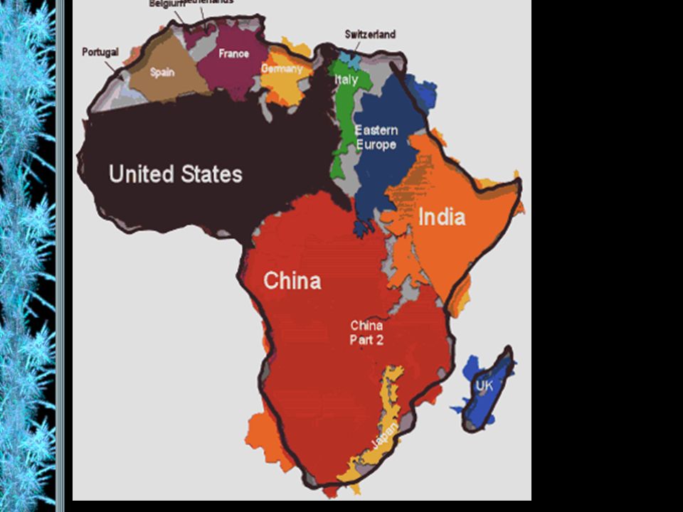
46
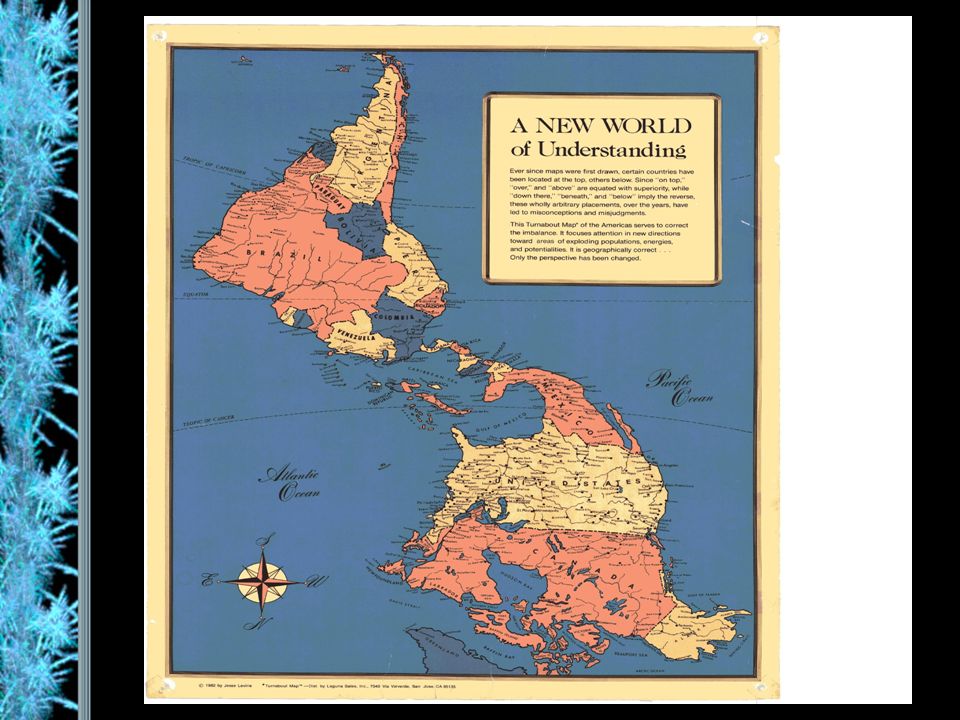
cartography – the science of making maps Maps provide a visual tool Maps are subjective Map projections transfer locations on a round surface to a flat surface –some form of distortion always occurs –greater distortion results from larger areas depicted

47
global grid system

48
mathematics of the Earth Aristotle (384-322 BC) discovered the earth to be an oblate spheroid –Equatorial bulge 7926.38 (7924) –Polar shortening 7899.80 (7922) –23.5° axis (tilt)
 discovered the earth to be an oblate spheroid –Equatorial bulge (7924) –Polar shortening (7922) –23.5° axis (tilt)")
49
seasons and climate Earth’s rotation & movement around the sun Tilt of the earth’s axis (23.5°) Receipt of solar radiation Re-radiation of energy in the form of heat
 Receipt of solar radiation Re-radiation of energy in the form of heat")
50
the Earth’s divisions Latitude lines –Equal distance between lines –Lines become increasingly smaller descending from the equator to poles Longitude lines –Each line is the same exact length –All lines become increasingly close together as they descend to the poles –Connects the North and South Poles

51
important lines of latitude Equator: 0 degrees Tropic of Cancer: 23.5 degrees North Tropic of Capricorn: 23.5 degrees South Arctic Circle: 66.5 degrees North Antarctic Circle: 66.5 degrees South

53
important lines of longitude Prime Meridian: 0 degrees (runs through Greenwich, England) International Dateline: 180 degrees Time Zones: every 15 degrees of longitude equals one hour
 International Dateline: 180 degrees Time Zones: every 15 degrees of longitude equals one hour")
56
maps Scale –the smaller the scale, the greater the area –World map has smallest scale, city map has largest scale (think of scales like fractions) - for example one inch = one mile is more detailed than one inch = one hundred miles 1:1 or 1:100 Legend –interprets map information
 - for example one inch = one mile is more detailed than one inch = one hundred miles 1:1 or 1:100 Legend –interprets map information")
57
map projections & distortion Shape Distance Relative size Direction

58
Mercator: preserves direction, distorts landmass, used for navigation Fuller’s: preserves shape and size, distorts direction Robinson: minimizes projection errors Peters: equal- area projection, focus on Africa Azimuthal: oriented to the Poles

59
Robinson map projection

60
Fuller’s Dymaxion projection

62
Topographical map

63
Thematic maps

64
Cartogram map

65
Geographical Information Systems

67
mental maps

68
Formative Assessment(s) State one benefit and one limitation of each of the projections below: Mercator Fuller Robinson Azimuthal
 State one benefit and one limitation of each of the projections below: Mercator Fuller Robinson Azimuthal")
Similar presentations