Download presentation
Presentation is loading. Please wait.

1
Unit 1: Basic Concepts

2
Geography Human Geography Physical Geography Earth To write
The study of where and why human activities are located where they are (i.e. religions, businesses, and cities) The study of where and why natural forces occur as they do (i.e. climates, landforms, and types of vegetation)
 The study of where and why natural forces occur as they do (i.e. climates, landforms, and types of vegetation)")
3
VOCABULARY Map- 2 dimensional or flat scale model of the Earth’s surface or a portion of it Place- specific point on Earth distinguished by a particular characteristic Region- area of Earth distinguished by a distinctive combination of cultural and physical features Scale- relationship between the portion of Earth being studied and the Earth as a whole Space- the gap between 2 objects Connections- relationships between people and space

4
How Do Geographers Describe Where Things Are?

5
Reference tool Communications tool
A map could be drawn on the back of a cocktail napkin, computer-generated, or a work of art Reference tool Communications tool A map helps us to find the shortest route between two places and to avoid getting lost along the way Where something is in relation to another place Ex. atlas or road map A map can depict the distribution of human activities or physical features and why they are distributed that way

6
Eratosthenes: first to record the use of the word geography
Ptolemy: wrote Guide to Geography; first to codify the basic principles of mapmaking Eratosthenes: first to record the use of the word geography Aristotle: first to say earth was spherical

7
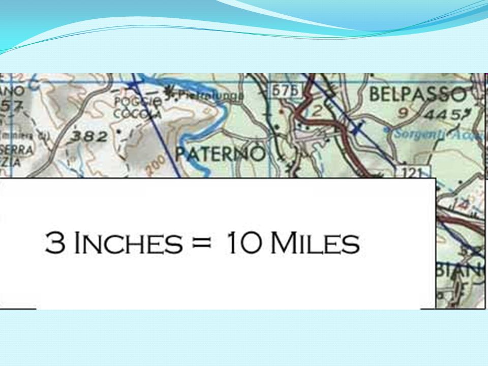
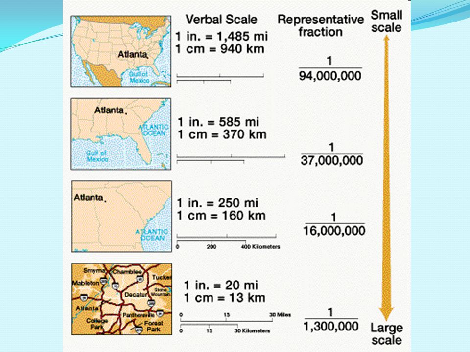
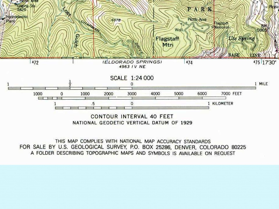
Map Scale Scale refers to the relationship of a feature’s size on a map to its actual size on earth. It is represented in three ways: A ratio or fraction A written scale A graphic scale

8
A ratio or fraction: This shows the numerical ratio between distances on the map and Earth’s surface. 1:24,000 or 1/24,000 means that 1 unit (usually an inch) on the map represents 24,000 of the same unit on the ground. This is also called the RF scale or representative fraction.
 on the map represents 24,000 of the same unit on the ground. This is also called the RF scale or representative fraction.")
9
Topographic map showing RF scale

10
A written (verbal) scale:
Describes the relation between map and Earth distances in words. 1 inch equals 1 mile

12
A graphic scale: Usually a bar line marked to show distance on Earth’s surface.

16
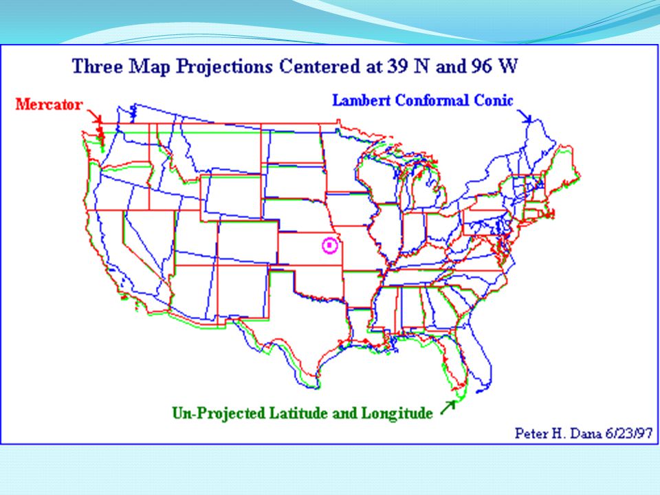
Map projection: Scientific method of transferring locations on Earth’s surface to a flat map. Different projections show distortion in: Shape Distance Relative size Direction

17
Shape

18
Distance

19
Relative size

20
Direction

22
India Map of Kashmir Pakistan Map of Kashmir

23
Types of maps Page IX - X in atlas
Maps helps us visualize info Internet use 1996, 2001, 2007, 2015

24
1. Robinson Projection Pro: Useful in displaying information across oceans along longitude lines Con: Shows a larger proportion of water to land than actuality

25
2. Mercator Projection Pro: works for navigation around the Equator
Con: area is extremely distorted towards the poles

26
3. Equal Area Projections
Azimuthal and Goode’s Interrupted Homolosine Pro: Very little distortion to landmasses Con: Discontinuities in oceanic regions

27
Types of Maps Physical maps show elevation, mountains, rivers, deserts etc…

28
Types of Maps Political maps show countries, cities, capitals, counties.

29
Special purpose maps Maps designed for a special purpose. Highway maps, population maps, etc…

30
Maps have four properties
Maps have four properties. When you take a round globe and “flatten” it, one or more of these properties will be “distorted.” The properties of maps include: scale distance area direction

31
4. Choropleth maps Applies distinctive colors to represent different quantities or densities Typically on a map of a formal region (political)
 .")
33
5. Dot distribution/Dot Density map
Shows distribution using a concentration of dots Each dot represents the same quantity Used for population density

34
6. Isopleth of Isoline maps
Used to portray quantities that vary smoothly over a given area Joins locations with the same value Used for climate variables

35
7. Proportional symbol map
Portrays numerical quantities Symbols are drawn proportional to the value at that location

36
8. Cartogram Deliberately distort map shapes to achieve special effects

37
Mercator Projection

38
Robinson Projection

39
Equal-Area Projection

40
Azimuthal-Polar

41
MAP PROJECTIONS 3. Draw in these shapes/projections in your notes… and answer the 3 questions for EACH projection A. What is distorted? B. What is the map used for? C. How can you recognize this map? Name Name Name Name

42
U.S. Land Ordinance of 1785 -divided the country into a system of townships and ranges to facilitate the sale of land in the West

43
Township- square composed of 6 miles/side
Principle meridians- north-south lines separating townships Base lines- east- west lines separating townships Section- township is divided into 36 of these, 1 mi by 1 mi Quarter-section- .5 mi by .5 mi or 160 acres, considered a homestead to pioneers

44
Latitude and Longitude

45
Latitude Lines Imaginary lines that run east to west around the globe
Measure degrees north and south of the Equator The Equator is at 0 degrees

46
The imaginary line at 0° latitude, or at 0° on an X Axis
The Equator The imaginary line at 0° latitude, or at 0° on an X Axis

47
Helpful Hint The steps of a ladder- ladder sounds like latitude- make the latitude lines.

48
Each degree of latitude and longitude is divided into 60 minutes, and each minute divided into 60 seconds

49
Longitude Lines Imaginary lines that run from the north pole to the south pole Measure degrees east and west of the Prime Meridian The Prime Meridian is at 0° Longitude, or at 0° on a Y Axis

50
The imaginary line at 0° longitude
The Prime Meridian The imaginary line at 0° longitude

51
Helpful Hint: If you stretch your body out as LONG as you can make it- this is a longitude line…

52
Calculating Latitude and Longitude
Always calculate Latitude First North and South of the Equator Then calculate Longitude East and West of the Prime Meridian

53
How to Read Latitude and Longitude
If you know the latitude and longitude of a place, put one finger on the line of latitude and another on the line of longitude. Bring your fingers together until they meet.

54
It helps to make a map North East North West South West South East
Prime Meridian Equator South West South East

55
USING AN ATLAS OR TEXTBOOK LOCATE THE COORDINATES AND WRITE DONE THE NAME OF THE CITY.

Similar presentations


. Location – the space.>")


 The study of.>")
