Download presentation
Presentation is loading. Please wait.

1
PERTEMUAN 4 GEOGRAFI KOTA TPL-101 Principal of Urban Geography
GIS and spatial analysis: introduction and overview DR. SUPRAJAKA dan DR. RATNAWATI YUNI SURYANDARI Fakultas Teknik Universitas Indonusa Esa Unggul

2
Urban geography Why cities? Where? Suburbanization
Internal spatial dynamics Suburbanization Inner cities

3
What is a city? A central place (exports good and services to a larger region) A place of a certain size and density 200 in Denmark 2,000 in the U.S. 20,000 in Japan A recent phenomenon (3% in 1800)
")
4
Why cities? Specialization of labor Agglomeration and efficiency
Economies of scale Sharing suppliers, customers, services Administration and organization Defense

5
Where are cities? Site: characteristics of the place itself
Situation: relative characteristics Gateway to gold country At a silver deposit Head of navigation On a railroad Waterfall River delta

6
Ancient cities Crossroads, water sources Jericho (9000 BC)
Catal Huyuk (6000 BC) Memphis (3000 BC) Cooperation on irrigation, defense Ur (5000 BC) Interdependence of city and country
 Memphis (3000 BC) Cooperation on irrigation, defense. Ur (5000 BC) Interdependence of city and country.")
7
Catal Huyuk Jericho

8
Medieval cities Small by today’s standards
1 square mile; 300,000 inhabitants Surrounded by wall, farm fields Military strategy, religion, crossroads Organic city plan

9
Köln/Cologne, Germany

10
Tombouctou/Timbuktu, Mali

11
Industrial cities Rapid urban growth
New cities: close to power sources, markets Coalfields (Manchester, UK) Water power (Lowell, MA) Health and social issues London (Dickens) Chicago (The Jungle)
 Water power (Lowell, MA) Health and social issues. London (Dickens) Chicago (The Jungle)")
12
World cities Based on services, not goods
Face-to-face contact, communications Global orientation, internal inequalities NYC, London, Tokyo

13
Economics of cities Your responsibility! Basic vs. nonbasic industries
Multiplier effect

14
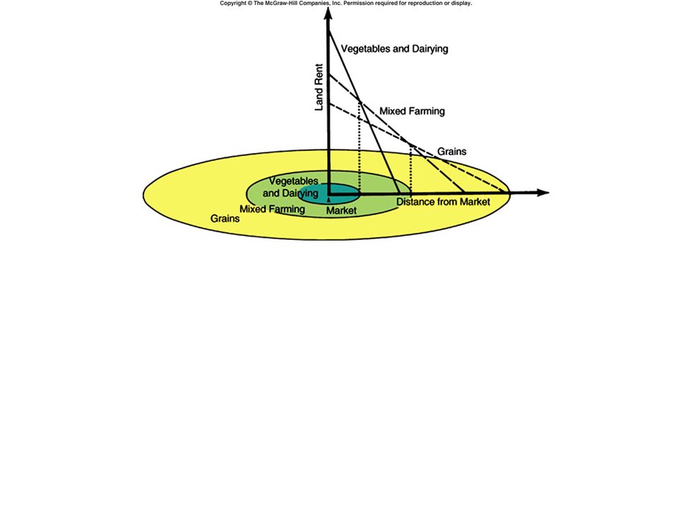
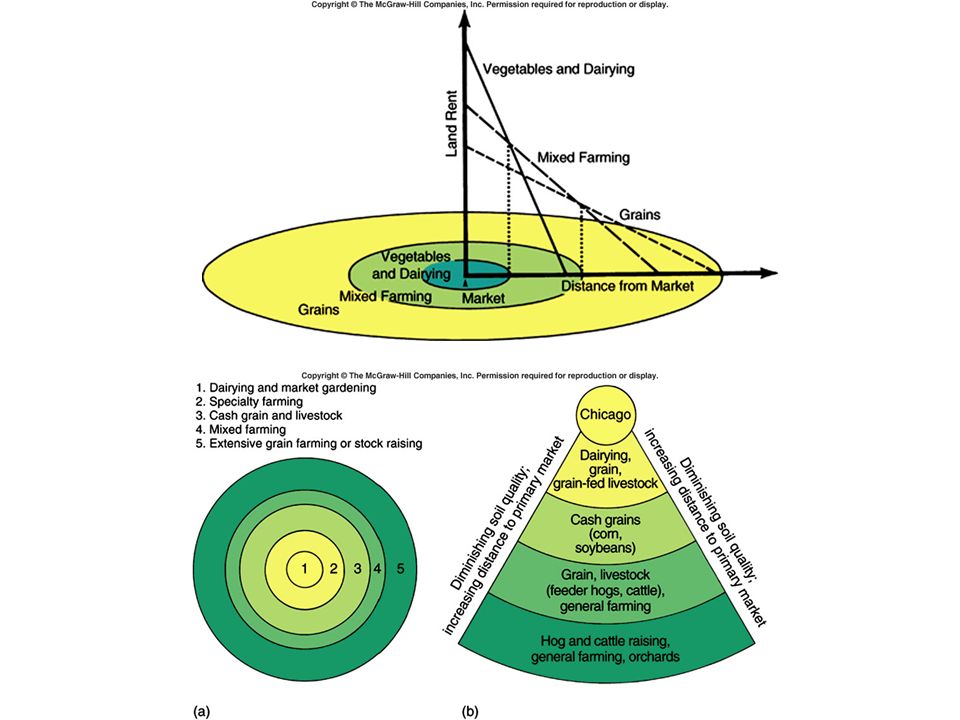
Von Thünen’s land use model
German landowner in 1800s Noticed pattern of agricultural land use Three assumptions: Isolated city (no trade) Surrounded by homogenous landscape All that matters is transport costs
 Surrounded by homogenous landscape. All that matters is transport costs.")
15
Land value Distance from market

16
Land value Distance from market

17
Land value Distance from market

18
Land value Distance from market

19
Land value Distance from market

20
Land value Distance from market

23
Urban land use models CBD: “highest and best use” What happens beyond?
Three models of Chicago “Featureless plain” University of Chicago Not mutually exclusive

24
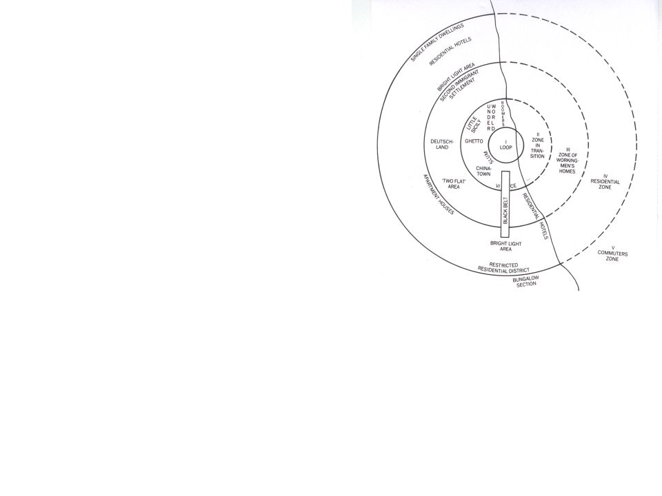
Concentric circles Sociologist in 1920s CBD, then “zone of transition”
Working-class homes Middle-class homes Commuter suburbs Urban ecology: invasion and succession

26
Sector model Economist in 1930s
Central activities expand out by sector High-end housing in attractive sector Industrial near transportation Middle-class housing next to high-end Lower-class housing gets the rest

27
Sector model Status displayed via housing
Middle class always moves outward Vacancy chains start Fastest growing suburbs = poorest inner city

28
Buffalo SLC Chicago

29
Multiple nuclei Geographers in 1940s CBD isn’t the only center
Commercial, industrial, port, etc. “nodes” Expanding nodes intersect

31
Suburbs and inner cities
Suburban residents and jobs came from somewhere Growth now limited to suburbs Segregation by class, race Falling tax income, rising service needs Spatial mismatch: jobs moved, poor didn’t

32
Suburbs and inner cities
But agglomeration still matters And immigrants still arrive in cities Increasing redevelopment of downtowns LoDo in Denver Battery Park in NYC Jack London Square in Oakland Train station in Sacramento

Similar presentations

 Metropolitan area: Central city + Counties that commuters come from.>")


. MAJOR GEOGRAPHIC QUALITIES Western extremity of Eurasia Lingering world influence High degrees of specialization Manufacturing.>")


>")


