Download presentation
Presentation is loading. Please wait.

1
Climate, weather, and storms

2
Weather and climate Weather is day-to-day variability of temperature, pressure, rainfall, wind humidity, etc. Climate is the long-term average of weather for a particular region (local, regional, or global)
.")
3
Incoming solar radiation Approximately 50% of the solar energy that strikes the atmosphere reaches Earth’s surface 30% is reflected back to space 20% is absorbed by clouds and the atmosphere’s gases

4
Most outgoing Earth radiation is intercepted and absorbed by greenhouse gases like water vapor, methane, and carbon dioxide.

5
What are the greenhouse gases? (excluding H 2 O) Carbon Dioxide:49% Methane:18% “CFC’s from coolants, solvents, etc ”:14% Nitrous Oxides: 6% Others:13%
 Carbon Dioxide:49% Methane:18% CFC’s from coolants, solvents, etc :14% Nitrous Oxides: 6% Others:13%.")
6
The greenhouse effect

7
Some atmospheric basics The greenhouse effect Radiant energy that is absorbed heats Earth and eventually is reradiated skyward –Radiation is in the form of longwave infrared radiation –Atmospheric gases, primarily H 2 O and CO 2, are more efficient absorbers of longwave radiation –This selective absorption, called the greenhouse effect, results in warming of the atmosphere

8
Climate is fundamentally driven by energy from the Sun. Changes in the energy budget at Earth’s surface are primarily affected by changes in the solar energy received by Earth –Secondary effects: differences in albedo, and atmosphere composition

9
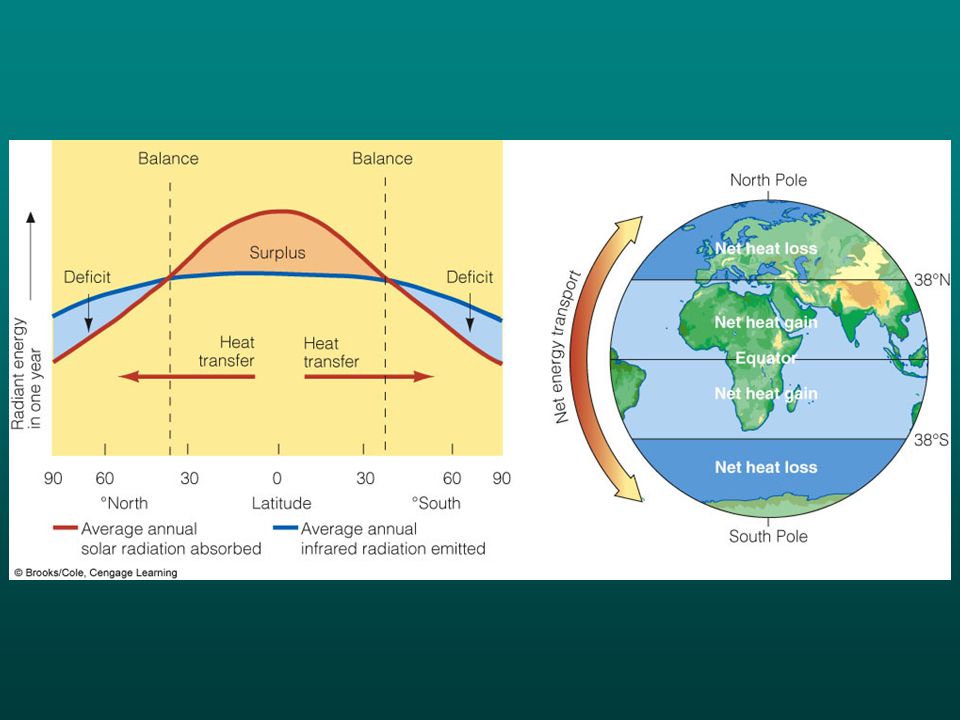
Latitudinal variation in solar input

12
Multi-year time scale variations El Nino and La Nina are important phenomena Occur every ~2 to 7 years when typical ocean-atmosphere circulation breaks down

13
During normal years, warm surface waters in the Pacific lie in the east off Indonesia When the pattern oscillates to an “El Nino”, the warm water shifts east “La Nina” is characterized by colder sea-surface temperatures and stronger trade winds in the eastern tropical Pacific

14
South America During “Normal Years” Warm water in the western Pacific causes low pressure and high rainfall; pressure system drives tradewinds from east to west; tradewinds drive warm water to the west; causing cold water to rise off South America and flow west.

15
South America During “El Nino” Warm water shift to the eastern Pacific causes drought in western Pacific; low pressure over the warm eastern Pacific causes heavy rains and inhibits upwellings along the coast of South America.

16
South America During “El Nino” Warm water shift to the eastern Pacific causes drought in western Pacific; low pressure over the warm eastern Pacific causes heavy rains and inhibits upwellings along the coast of South America. Strong El Nino year 1982-83:

17
1982-83 El Nino Floods in Peru-Ecuador (600 fatalities) California flooding led to $300 million damages Hurricanes in Hawaii, Tahiti Australia: drought and wildfires
 California flooding led to $300 million damages Hurricanes in Hawaii, Tahiti Australia: drought and wildfires")
18
1997-1998 El Nino Effects

19
La Nina hazards Can bring warming and low rainfall to much of U.S. –Can lead to fires Allows growth of hurricanes in Atlantic

20
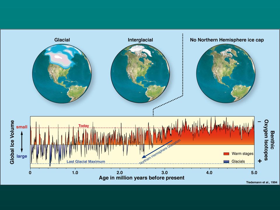
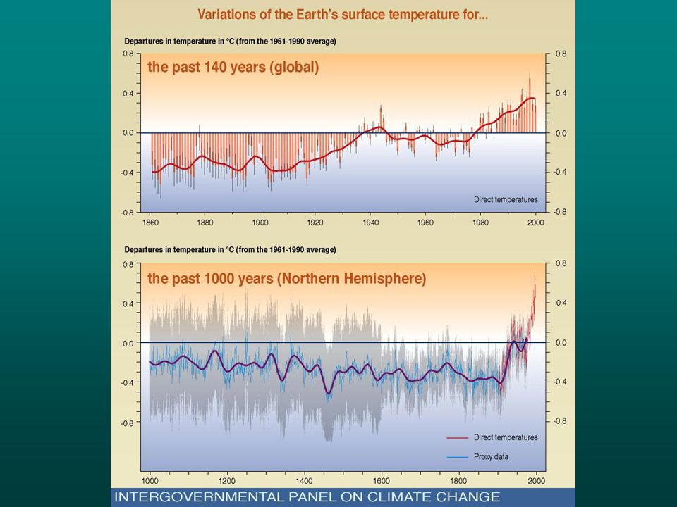
19582003 Climate Change

21
Records of Climate Change National Academy of Science Report, 2006

22
Records of Climate Change Historical data Proxy data –Marine sediment –Ice –Coral –Lake sediment –Tree Rings –Boreholes –Glacial advance/retreat –Old glacial deposits, etc.

23
Oxygen isotopes Same atomic number (8) Different atomic mass 99.63%0.0375% 0.1995% concise.britannica.com
 Different atomic mass 99.63%0.0375% % concise.britannica.com")
24
Delta notation

25
Ice data Influence of temperature on ice composition Record of atmospheric composition

26
earthobservatory.nasa.gov Composition of precipitation versus temperature

27
Greenland and Antarctic Ice Sheet Records >700,000 yrs Layers counted like tree rings Greenland and Antarctic Ice Sheet Records >700,000 yrs Layers counted like tree rings Photos: NASA

28
Figure 21.5A

31
Interpreted from Greenland ice core O-isotope data

32
Seafloor record Microfossils of organisms in surface and bottom water Limited by age of oceanic crust (oldest ~180 my)
")
33
Source: NOAA

34
Influence of ice volume on O- isotope composition of seawater

35
Ice is depleted in 18 O Residual seawater is enriched in 18 O Positive ( 18 O-enriched) values of organisms indicate larger ice volume Influence of ice volume on O- isotope composition of seawater
 values of organisms indicate larger ice volume Influence of ice volume on O- isotope composition of seawater")
36
Figure 21.4

38
Temperature effects The ratio of 18 O to 16 O in foraminifera shells varies slightly depending on the temperature of the surrounding water, as well the water's salinity.

39
Dealing with temperature effect Use benthic organisms in from deep bottom waters (relatively constant temperature) Use trace element ratios tied to precipitation temperature (e.g., Sr/Ca)
 Use trace element ratios tied to precipitation temperature (e.g., Sr/Ca)")
40
Figure 21.8

41
Annual growth rings in x-rayed coral (NASA)
")
42
Chapter 21 Opening Figure

43
Figure 21.6 Ring thickness and density a function of climate (e.g., high latitude and altitude trees sensitive mainly to temperature)
")
44
Cross dating in dendrochronology

45
Mapping glacial deposits

46
Figure 18.32 300 my old glacial deposits on Pangaea

47
Long term climate record

48
Climate Variations over Time Early earth: atmosphere full of CO 2 Surface would have been much hotter because of greenhouse effect What changed? Much CO 2 has gone into rock form (limestones primarily)
.")
50
Figure 21.5B Interpreted from Greenland ice core O-isotope data

Similar presentations


![Climate: What we know about it, How we know about it, and What we’re doing to it.]](/17/5339947/big_thumb.jpg "Climate: What we know about it, How we know about it, and What we’re doing to it.]>")

 Physical Oceanography>")


 McGraw Hill Ryerson 2007 11.1 Natural Climate Change “Climate” describes the average conditions of a region. Climate is usually measured over a minimum.>")

