Download presentation
Presentation is loading. Please wait.

1
Test Review Earth Movements Climate & Weather Map Skills

2
Printing Instructions An effective use of this study guide is to Print “As a handout”. Select Handout in the dropdown menu under Print what. Select 6 slides per page, then Print Fold the pages lengthwise. Then the question will appear on one side and the answer on the other side.

3
Using your U.S. Map, what direction is it from South Dakota to Oklahoma?

4
South

5
Using your U.S. Map, what direction is it from Texas to Maine?

6
Northeast

7
How long does it take for the Earth to revolve one time?

8
365 ¼ days or one year

10
Northwest

11
Places with a marine climate usually have ___________________ summers and winters than places further away from the sea.

12
Milder or less extreme

13
Using your U.S. Map, what direction is it from Nevada to Colorado?

14
East

15
This imaginary line divides the Earth into Northern and Southern Hemispheres

16
Equator

18
South

19
This type of climate is hot and rainy all year.

20
Tropical

21
Using your U.S. Map, what direction is it from New Mexico to Oregon?

22
Northwest

23
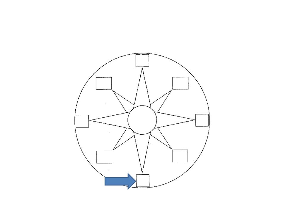
North, South, East, and West

24
Cardinal Directions

26
Northeast

27
This is a year when the ocean surface water is warmer.

28
El Nino

29
When an object spins on its axis.

30
Rotation

32
West

33
The climate of places near the ocean or sea.

34
Marine

35
Using your U.S. Map, what direction is it from Minnesota to Georgia?

36
Southeast

37
An area of cloudy rainy weather near the Equator

38
Doldrums

39
Use your ruler and the atlas to help you determine the distance between the following cities. Remember, 1 inch = 200 miles. New York, City & Boston, Mass.

40
Use your ruler and the atlas to help you determine the distance between the following cities. Remember, 1 inch = 200 miles. New York, City & Boston, Mass. 200 Miles

42
Southeast

43
The average weather conditions of an area over a long period of time

44
Climate

45
Use your ruler and the atlas to help you determine the distance between the following cities. Remember, 1 inch = 200 miles. Houston, Texas and Miami, Florida _____

46
Use your ruler and the atlas to help you determine the distance between the following cities. Remember, 1 inch = 200 miles. Houston, Texas and Miami, Florida _____ 1,000 Miles

48
North

49
Using your U.S. Map, what direction is it from Florida to Nebraska?

50
Northwest

51
The sides of mountains facing away from oceans are often _________

52
Dry

54
Southwest

55
Using your U.S. Map, what direction is it from New York to Arkansas?

56
Southwest

57
The tilt of the Earth’s axis causes the _____________________ to change.

58
Seasons

59
A very large body of salt water. There are only 5 in the world.

60
Ocean

61
Use your ruler and the atlas to help you determine the distance between the following cities. Remember, 1 inch = 200 miles. Denver, Colorado & St. Louis, Missouri

62
Use your ruler and the atlas to help you determine the distance between the following cities. Remember, 1 inch = 200 miles. Denver, Colorado & St. Louis, Missouri 800 Miles

64
East

65
What the atmospheric conditions are at one place on one day or time.

66
Weather

67
The climate of places not near the ocean or sea.

68
Continental

69
When one object moves around another one.

70
Revolving or Revolution

71
Use your ruler and the atlas to help you determine the distance between the following cities. Remember, 1 inch = 200 miles. Los Angeles, California and Phoenix, Arizona _______

72
Use your ruler and the atlas to help you determine the distance between the following cities. Remember, 1 inch = 200 miles. Los Angeles, California and Phoenix, Arizona _______ 400 miles

73
These climates have cooler temperatures as you increase elevation.

74
Highland

75
An imaginary line connecting the North and South Poles upon which the Earth rotates. It is tilted.

76
Axis

77
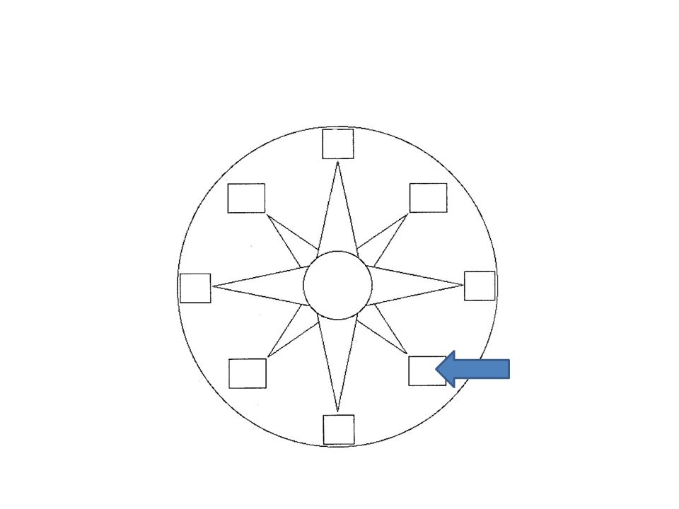
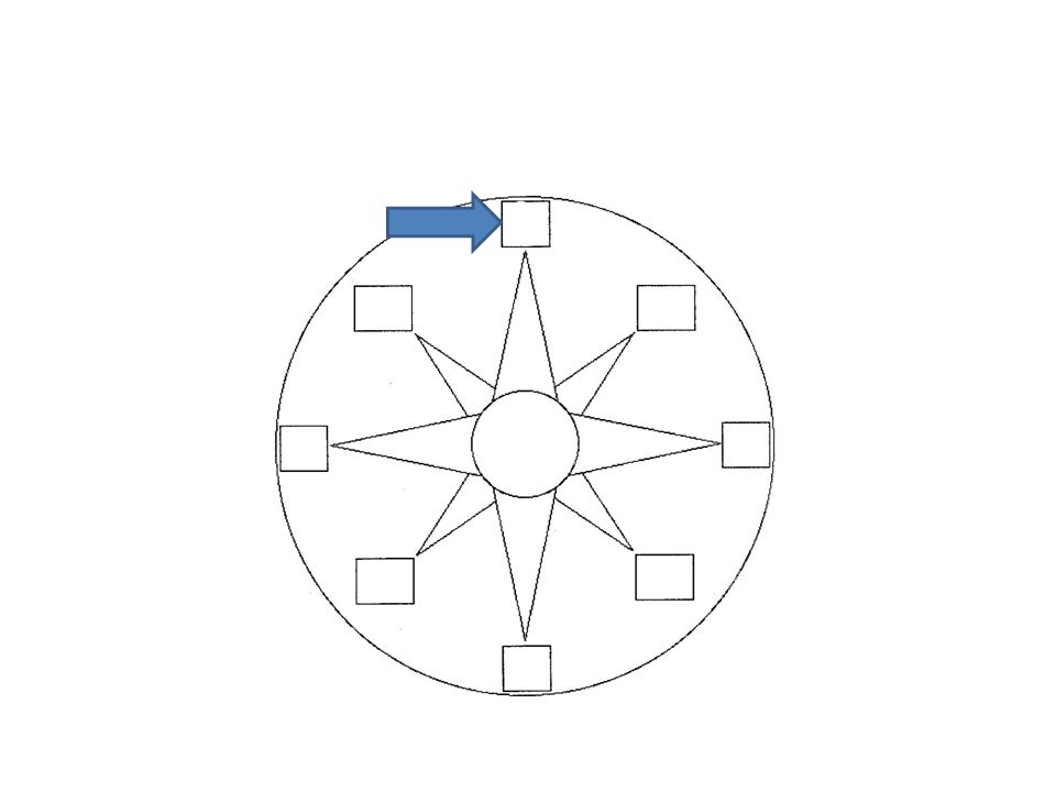
Northeast, Southeast, Southwest, & Northwest

78
Intermediate Directions

79
A very large land area. There are only 7 in the world.

80
Continent

81
Study Tonight!

Similar presentations