Download presentation
Presentation is loading. Please wait.

1
Property Legal Descriptions

2
u Method of establishing legal description and location of properties u 3 basic systems –metes & bounds –rectangular system –lot & block

3
Metes and Bounds u Measurements and boundaries used to identify the perimeters of any property. –metes commonly measured in feet –boundaries established as bearings

4
Metes and Bounds u Bearings are directions with reference to one of the quadrants of the compass –360 degrees in a circle –90 degrees in a quadrant –degrees may be divided into minutes and seconds »1 degree (1 o ) = 60 minutes (60’) »1 minute (1’) = 60 seconds (60”)
 = 60 minutes (60’) »1 minute (1’) = 60 seconds (60 )")
5
Metes and Bounds u Bearings are measured clockwise or counterclockwise from either north or south u Example –N60 o E –S35 o 45’15”W

6
Metes and Bounds u Survey begins with monument called point-of-beginning or POB –fixed location such as iron rod, rocks, trees u Plot plan laid out with respect to POB

7
Rectangular System u Established by US Bureau of Land Management (BLM) u Based on –latitude (parallels running east/west) –longitude (meridians running north/south)
 u Based on –latitude (parallels running east/west) –longitude (meridians running north/south)")
8
Rectangular System u Intersection of 2 establishes a reference point –base lineslines of latitude –principal meridianslines of longitude u Were used to establish areas known as great land surveys –32 sets in continental US –5 set in Alaska –most given local names

9
Principal Meridians & Baselines of Great Land Survey

10
Rectangular System u Land surveys broken down into smaller surveys u Quadrangles –24 miles x 24 miles u Township –6 miles x 6 miles (36 square miles) –located with respect to baseline & principal meridian »Township NumberNorth or South from Baseline »Range NumberEast or West from Principal Meridian
 –located with respect to baseline & principal meridian »Township NumberNorth or South from Baseline »Range NumberEast or West from Principal Meridian")
11
Townships 1 2 3 4 123 4

12
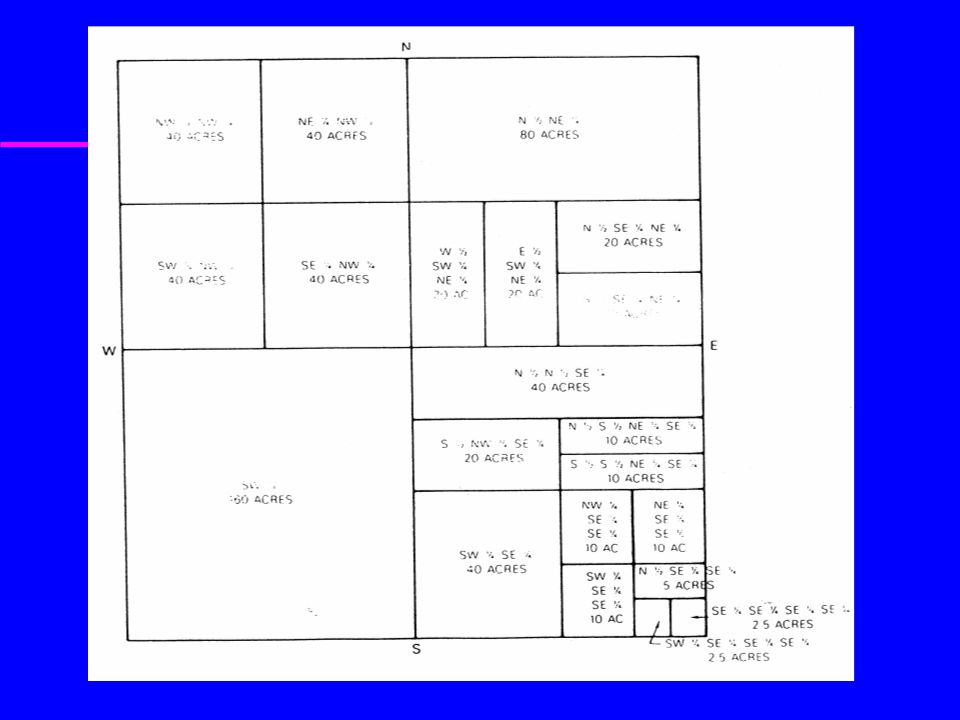
u Orem Area –Salt Lake Meridian Principal –T6N,R39E u Sections –1 mile x 1 mile (1 square mile) –640 acres, 1 acre = 43560 sq. ft. –36 per township

13
Sections u Each section in a township is number as shown

14
Sections u Sections may be further divided –1/4 section –160 acres

15
Sections u 1/4 of 1/4 section u 40 acres

17
Sections Locate the SE 1/4, NE 1/4 N S E W NW NE SW SE NWNE SWSE

18
Where’s Brother Miller’s Home? The N 1/2 of the SW 1/4 of the NW 1/4 of the NW 1/4 of Section 15, T6N, R39E, Boise Meridian, County of Madison, State of Idaho

19
Lot & Block System u Commonly used when a portion of land is subdivided into individual building sites u Subdivision given name –broken into blocks & lots u Subdivision established as a legal plot and recorded in county records

20
Plot Plans u A map of a piece of land u Commonly used for construction purposes to show location of house on property

21
Plot Plans u May include –legal description of property –property line bearings & directions –north direction –utility, easements, & setbacks –elevations & contour information –existing/proposed vegetation & structures –map scale

22
Plot Plan Example

23
Commercial Site

Similar presentations


. The Public Land Survey System (PLSS) was developed by the Continental Congress to replace the common practice of describing.>")


