Download presentation
Presentation is loading. Please wait.

1
LEGAL DESCRIPTIONS OF LAND
Three Methods Commonly Used: 1. Rectangular Survey 2. Metes and Bounds 3. Recorded Plat Rectangular survey system was established in the 1700s to describe large tracts of land. It is based on a grid-type system to make it easier to describe and locate land than the older metes and bounds system that was brought to this country by settlers. Metes and Bounds describes property boundaries in terms of reference points. It starts at a beginning point and moves through a series of references points to follow the boundaries of the property back to the beginning point. Recorded Plat was developed to simplify the location and description of small parcels. It primarily assigns lot numbers to individual sites when land is subdivided. It is used with both of the other systems. It is also know by other names such as lot and block system, recorded map, recorded survey system.

2
In general, the rectangular survey system is used in the public domain states of the mid-west and western U. S. and the metes and bounds system is used in the Colonial States in the eastern U. S. The metes and bounds system was used in the eastern U. S. prior to the development of the rectangular survey system. When the U. S. acquired the Louisiana Purchase, the Mexican Territory, and the Oregon Territory, a system of legal descriptions for large parcels was needed. These areas plus Mississippi, Alabama and Florida are the primary areas that use the rectangular survey system. Texas, which a number of Spanish land grants, uses the metes and bounds system.

3
The rectangular survey is based on system of principal Meridians and Base Lines. These are unique to certain areas. For example, all properties in Florida a based off of the Tallahassee Principal Meridian and Base Line. You can see in this diagram (Figure 7..1), these unique areas are designated by different shading.
, these unique areas are designated by different shading.")
4
RECTANGULAR SURVEY Also known as the Government Survey System.
Established by a land ordinance in 1785 Used in the first public land survey in 1786 in Ohio. Principal method used for land west of the Ohio and Mississippi rivers and in Florida, Alabama & Mississippi. East-West lines established for survey are base lines.

5
… RECTANGULAR SURVEY North-South lines are called principal meridians.
Each principal meridian has a unique name and is crossed by its own base line. Figure 7.1 that we just viewed illustrates the location of the principal meridians and base lines

6
This map is taken from the USDA’s 1958 Yearbook of Agriculture: LAND

7
… RECTANGULAR SURVEY Rectangular survey system is based on a system of north-south lines which are six miles apart and called range lines and by east-west lines six miles apart called township lines. Rectangles created by these intersecting lines are called townships (6 mi. X 6 mi.) In addition to the principal meridians and base lines, the rectangular survey system is based on a grid of range and township lines that are 6 miles apart. Range lines run North and South Township lines run East and West These lines form a block of land that is 6 mi. by 6 mi. – called a “township” 36 sq.mi.
 In addition to the principal meridians and base lines, the rectangular survey system is based on a grid of range and township lines that are 6 miles apart. Range lines run North and South. Township lines run East and West. These lines form a block of land that is 6 mi. by 6 mi. – called a township 36 sq.mi.")
8
This is similar to Figure 7. 2 and 7. 3 in your text
This is similar to Figure 7.2 and 7.3 in your text. The shading in the text made it difficult to make a copy that could be read. I took this from a CD that had a draft of this chapter in it. In Spring of 2000, I taught this course from a draft of the book before it was published later that year. Township lines north of the base line are T1N, T2N, etc. The same pattern applies to the south. Range lines east of the Principal Meridian are R1E, R2E, etc. Those to the west are R1W, etc. Figure 1 illustrates the township and range lines and how they form townships of 6 x 6 mi. blocks What is the township in the upper right portion (hatched area) of Figure 1? T4N, R5E Numbering of section is unique: Start in the upper right hand corner (NE), and number to the left, move down and number to the right, etc. Sec. 1, T5S, R8W borders Sec. 6, T5S, R7W Sec. 36, T5S, R8W borders Sec.1, T6S, R8W Sec.1 of T7S, R17E of Tallahassee Meridian is a unique location –only one place in the system
 of Figure 1 T4N, R5E. Numbering of section is unique: Start in the upper right hand corner (NE), and number to the left, move down and number to the right, etc. Sec. 1, T5S, R8W borders Sec. 6, T5S, R7W. Sec. 36, T5S, R8W borders Sec.1, T6S, R8W. Sec.1 of T7S, R17E of Tallahassee Meridian is a unique location –only one place in the system.")
9
This is a similar figure from The Appraisal of Real Estate, 11th edition.
They refer to it as the “Government Survey System”

10
These are examples of the description of blocks (parcels) of land within a section.
Section can be divided equally into quarter sections. NE 1/4 of Section 1 A quarter section can be divided into half (E 1/2 of NW ¼ of Section 1) A quarter section can be divided into 4 equal parts (NE ¼ of the SW ¼ of Section 1) A quarter section can be divided into equal halves or quarters N ½ of NW ¼ of SE ¼ of Section 1 NE ¼ of SW ¼ of SE ¼ of Section 1 Section is 1 mile square = 640 acres quarter section = 160 acres 1 mile = 5280 feet 1 acre = 43,560 sq. ft. We will not use rods and chains in this class.
 A quarter section can be divided into 4 equal parts (NE ¼ of the SW ¼ of Section 1) A quarter section can be divided into equal halves or quarters. N ½ of NW ¼ of SE ¼ of Section 1. NE ¼ of SW ¼ of SE ¼ of Section 1. Section is 1 mile square = 640 acres quarter section = 160 acres. 1 mile = 5280 feet. 1 acre = 43,560 sq. ft. We will not use rods and chains in this class.")
11
Figures 7.4 and 7.5 contain errors in the description of parcels illustrated.
Class participation assignment: find these errors and provide the correct description

12
If you have a written legal description of a property, the easiest way of understanding the location of that property may be to start at the end of the description and work through to the beginning. Locate the 6th Principal Meridian Determine the range and township designation –- T2N, R3W (tells us that it is located NW of P.M. and base line Section 12 – tells us where in the township the section is located West ½ of SW ¼ of SE ¼ gives us the boundaries of this parcel within Section 12 Homework assignment No. 2: When you are asked to diagram a property, follow this example

13
METES AND BOUNDS Metes and bounds system was used in the U.S. prior to the development of the rectangular survey system Metes and bounds system is based on distances (metes) and bearings (bounds) from succeeding reference points around the perimeter of the real estate.
 and bearings (bounds) from succeeding reference points around the perimeter of the real estate.")
14
METES AND BOUNDS Describes the property using natural and man-made objects as reference points. Start at the point of beginning (POB) and move through several intermediate reference points before finally returning to POB. Points are survey reference points and may refer to marked stones, trees, a creek or corner of another property. Modern metes and bounds includes monuments at these points.
 and move through several intermediate reference points before finally returning to POB. Points are survey reference points and may refer to marked stones, trees, a creek or corner of another property. Modern metes and bounds includes monuments at these points.")
15
…METES AND BOUNDS The courses that one moves from point to point are identified in degrees, minutes and seconds of an angle from the north or south and typically measured linearly in feet.

16
…METES AND BOUNDS Metes and bound system is the primary method of describing real property in 21 states: Connecticut, Delaware, Georgia, Hawaii, Kentucky, Maine, Maryland, Massachusetts, New Hampshire, New Jersey, New York, North Carolina, Pennsylvania, Rhode Island, South Carolina, Tennessee, Texas, Vermont, Virginia, parts of Ohio and Oregon, and the District of Columbia.

17
…METES AND BOUNDS Example:
“Begin at the middle of a large, white pine stump standing in the west side line of Simon Vender Cook’s land and on the south side of the main road that leads to the new city, and there is also a fence that stands a little to the west of Simon Vender Cook’s barn, which said fence if it were to run cross the said field southerly, would run to the middle of said stump; and running thence north 2 degrees east 19 chains and 50 links to a small white oak tree…” and so on, until one gets to the point of beginning. Source: LAND: The 1958 Yearbook of Agriculture. The U.S. Department of Agriculture. P.206

20
What is wrong with this figure?
All bearings and distances are the same. Apparently were copied

21
This is a copy of the figure from the draft that I reviewed from a CD
P.O.B. and move N 80 degrees 0 minutes 0 seconds 152 feet The S 80 degrees 0 minutes 0 seconds 180 feet

22
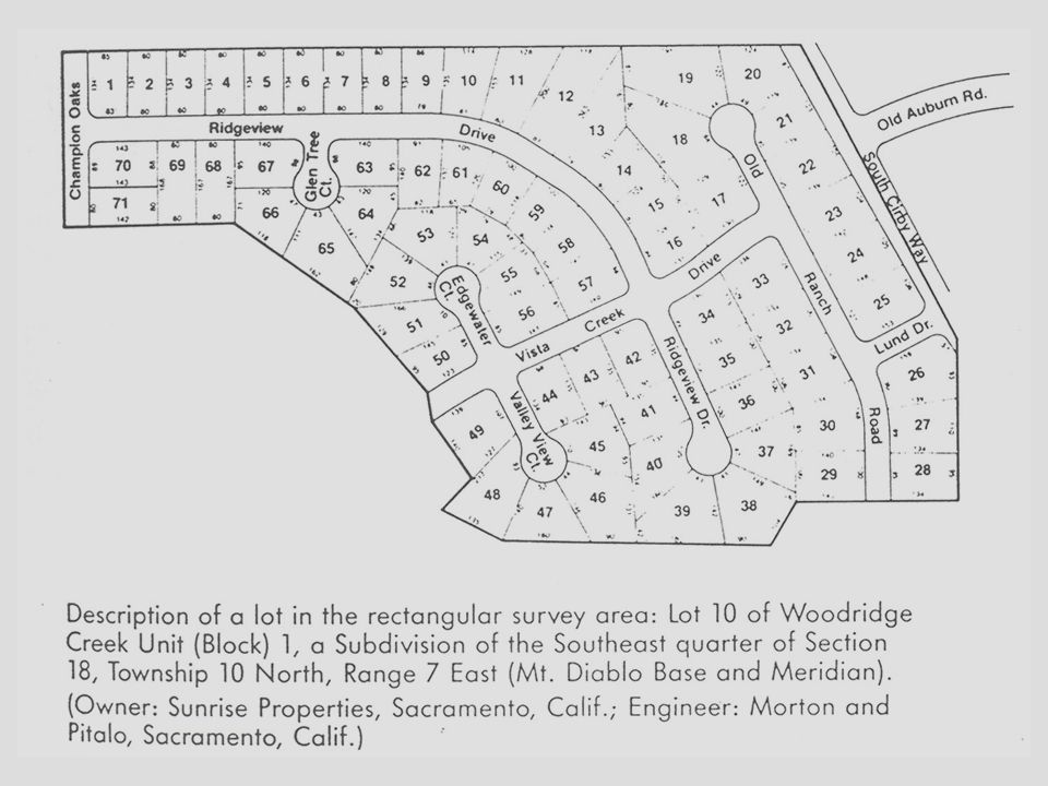
RECORDED PLAT Also known as lot and block, lot-block-tract, recorded map or recorded survey system Developed as an outgrowth of the rectangular survey system Used to simplify the locational descriptions of small parcels Established when land developers subdivided land and assigned lot numbers to individual sites within blocks Maps of subdivisions are filed with the local government to establish a public record of their precise locations. Each block identified precisely using a ground survey or established monuments.

23
… RECORDED PLAT Each Parcel is assigned a Lot Number Each Block is assigned a Block Number The Tract is assigned a name or Number prior to being recorded. Lot 10 of Woodridge Creek Unit (Block 1), a Subdivision of the Southeast quarter of Section 18 Township 10 North, Range 7 East of the Mt. Diablo Meridian
, a Subdivision of the Southeast quarter of Section 18 Township 10 North, Range 7 East of the Mt. Diablo Meridian.")
Similar presentations