Download presentation
Presentation is loading. Please wait.

1
RISK ANALYSIS,EVALUATION AND CHARACTERIZATION OF THE DIXIE OIL PROCESSORS INC., FRIENDSWOOD,TEXAS CVEN 610/PHEO 650 APRIL 22,2004 BY OKE NWANESHIUDU ABHIRAM KRISHNAN ARVIND KUTTY SIVASANKARI MUTHUSWAMY

2
Presentation Outline Site Description Data Evaluation and Assessment Exposure Assessment Toxicity Assessment and Risk Characterization Assumptions Conclusion

3
Stages in Risk Assessment Exposure Assessment Hazard Identification And Accounting Risk Characterization Exposure- Response Assessment Site Description Data Evaluation and Assessment Toxicity Assessment Exposure Assessment

4
Site Description Site Location Site Description Site Ranking Hydrology

5
Site Location Located on Dixie farm road, S. Harris County~ 20 miles SE of Houston,1.5 miles SW of interstate highway (Gulf Freeway). The west of the site is bordered by a stream called the Mud Gully which discharges into Clear Creek. Dixie Farm road divides the site into two segments North and South tract. Population around 5,000 people in 1 mile radius. Southbend subdivision is the nearest residential area.
. The west of the site is bordered by a stream called the Mud Gully which discharges into Clear Creek. Dixie Farm road divides the site into two segments North and South tract. Population around 5,000 people in 1 mile radius. Southbend subdivision is the nearest residential area..")
10
Site Description Site occupies ~26.6 acres Divided into two segments Northern and Southern tract Northern tract Occupies ~19 acres Used for storage purposes in impoundments and pits Southern tract Covers ~7.6 acres Used for processing activities

11
Site Description Open lands on NW and athletic field on the SW borders the site Open lands surrounding the site were used for oil and gas production Memorial Southeast hospital is located on the NW of the site Southbend Municipal water well is ~ 2 mi Southwest of the site

12
Site Ranking NPL Listing History HRS Score: 34.21 Proposed date: June 24 1988 Final Date: October 4 1989 NPL Update: 7

13
Site Hydrology West of the site bordered by a stream called Mud Gully Surface drainage from the site is into the Mud Gully Soils on the site consist of surface clay ~ 12-20 ft across the site Below Surface clay there is a uniform zone of sand filled channels (Numerous sand channel zone) Two water bearing zones identified: 1.Sand Channel Zone : Depth- 40-45ft 2.The 50ft sand aquifer: Depth 52-61.5ft
 Two water bearing zones identified: 1.Sand Channel Zone : Depth ft 2.The 50ft sand aquifer: Depth ft")
14
Site History 1969-1978 Intercoastal Chemical Company (ICC) operated copper catalyst recovery and hydrocarbon washing facilities on the DOP North Site DOP South began operations DOP began oil recovery at DOP South including cuprous chloride catalyst, hydrocarbon washing, oil washing and blending distilling residues from chemical plants 1984 Emergency removal of contaminated soils undertaken by DOP 1988 Remedy investigation and Feasibility studies (RI/FS) was completed Record of decision (ROD) signed on March 31 1988 1993 Remedy constriction activities were concluded on the site Completion of the project close out report 1998 Completion of the five yr review. The remedy remains protective of human health and environment

15
Data Evaluation and Assessment

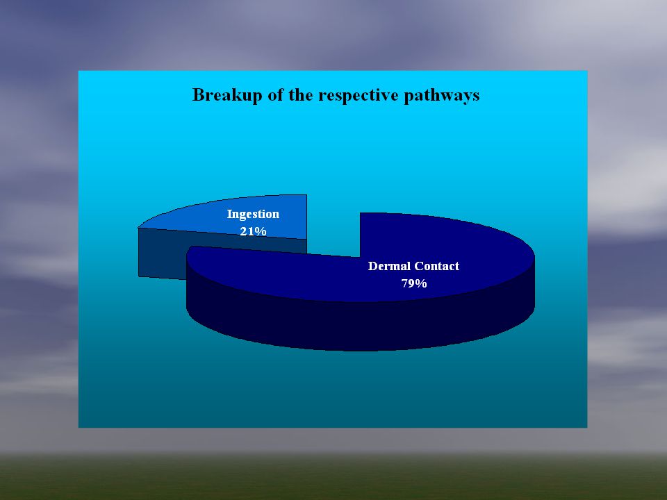
16
Some facts from the investigation LUSTs where found Samples where taken in 1988 Both sites where analyzed simultaneously and samples from 6 locations where taken Analyses of the air and soil samples from the south bend subdivision did not reveal significant impact

17
RAW Site data

18
Locations sampled

19
Assumptions No known uses of GW from the 50 ft sand zone There are supply wells intended for potable and non potable use We will use the following configuration for smart risk for the 3 locations Mud gully sediments = soil and dust Pit residual = soil and dust Ground water in monitoring well = Potable water

20
Final filtered data

21
DOP mud gully sediments (concentration)
")
22
NAPL fraction in GW Max values in well

23
DOP pit residual contaminants

24
Exposure Assessment

25
Potential Receptors: 1.Site Workers 2.Adults in neighboring residential Areas 3.Children in neighboring residential Areas

26
Exposure Assessment Contd.. Exposure Routes: Dermal Contact of soil and dust Ingestion of soil and fugitive dust Inhalation of fugitive dust

27
Exposure Assessment Contd.. The exposure via inhalation route from the dust were not considered due to inadequate data.

28
Exposure Scenarios Three exposure scenarios were considered based on the location and sources of contamination 1.Pit Residuals 2.DOP soil and dust 3.Ground water contamination

29
Pit Residuals Exposure routes Ingestion of soil and dust Dermal contact of soil and dust Target Population: Site Worker (Adult)
")
30
DOP Soil and Dust Exposure routes Ingestion of soil and dust Dermal contact of soil and dust Target Population: Site Worker (Adult)
")
31
Ground Water Contamination Exposure routes Ingestion of potable water Target Populations Industrial site workers Adults in residential areas Children in residential area

32
Toxicity assessment and Risk Characterization

33
Assumptions Fraction of contaminant for dermal exposure calculations were 0.001 For ingestion of potable water f = 0.00001 GI absorption factor = 0.63 (average value

34
Exposure Scenario 1 Pit residual – Brio/DOP

35
Conceptual Site model

36
Results Total Carcinogenic Risk - 5.74 e-05 –Vinyl Chloride – most potent in terms of individual risk (2.77 e- 05) Total Non-carcinogenic Risk - 1.24 e-01 –1,1,2 Trichloroethane - most potent in terms of individual hazard quotient (1.01e-01)
 Total Non-carcinogenic Risk e-01 –1,1,2 Trichloroethane - most potent in terms of individual hazard quotient (1.01e-01)")
37
Carcinogenic Risk

39
Non-carcinogenic risk

41
Exposure scenario 2 DOP mud gully sediments

42
Results Total Carcinogenic Risk - 1.36 e-06 –Indeno(1,2,3 cd) pyrene – most potent in terms of individual risk (7.58 e-07) Total Non-carcinogenic Risk - 2.77 e-03 –1,1,2 Trichloroethane - most potent in terms of individual hazard quotient (2.51 e-03)
 pyrene – most potent in terms of individual risk (7.58 e-07) Total Non-carcinogenic Risk e-03 –1,1,2 Trichloroethane - most potent in terms of individual hazard quotient (2.51 e-03)")
43
Carcinogenic risk

45
Non-carcinogenic risk

47
Exposure scenario 3 Groundwater contamination by NAPLs

48
Conceptual site model

50
Results Industrial - Ingestion of water (adults) Total Carcinogenic Risk - 5.28 e-04 –Vinyl chloride – most potent in terms of individual risk (2.58 e-04) Total Non-carcinogenic Risk - 2.75 –Bis(2 ethylhexyl)Phthalate - most potent in terms of individual hazard quotient (1.18)
 Total Carcinogenic Risk e-04 –Vinyl chloride – most potent in terms of individual risk (2.58 e-04) Total Non-carcinogenic Risk –Bis(2 ethylhexyl)Phthalate - most potent in terms of individual hazard quotient (1.18)")
51
Carcinogenic

52
Non-carcinogenic

53
Results Residential – Ingestion of water (adults) Total Carcinogenic Risk - 1.77 e-03 –Vinyl chloride – most potent in terms of individual risk (8.69 e-04) Total Non-carcinogenic Risk - 7.7 –Bis(2 ethylhexyl)Phthalate - most potent in terms of individual hazard quotient (3.3)
 Total Carcinogenic Risk e-03 –Vinyl chloride – most potent in terms of individual risk (8.69 e-04) Total Non-carcinogenic Risk –Bis(2 ethylhexyl)Phthalate - most potent in terms of individual hazard quotient (3.3)")
54
Carcinogenic

55
Non-carcinogenic

56
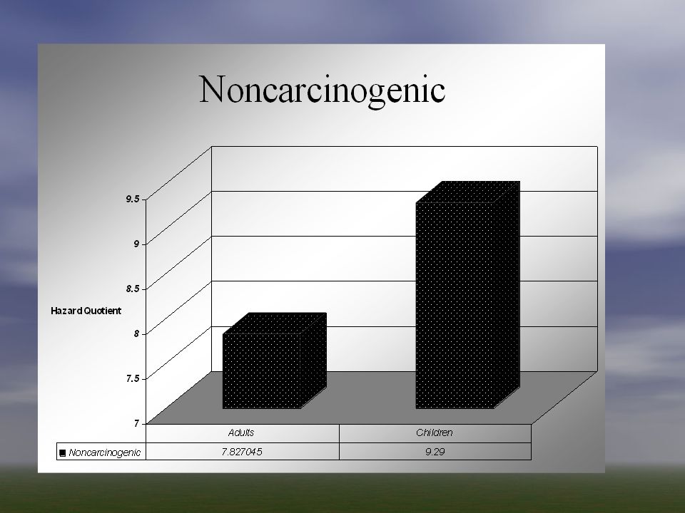
Results Residential – Ingestion of water (children) Total Carcinogenic Risk - 4.28 e-04 –Vinyl chloride – most potent in terms of individual risk (2.09 e-04) Total Non-carcinogenic Risk - 9.29 –Bis(2 ethylhexyl)Phthalate - most potent in terms of individual hazard quotient (3.99)
 Total Carcinogenic Risk e-04 –Vinyl chloride – most potent in terms of individual risk (2.09 e-04) Total Non-carcinogenic Risk –Bis(2 ethylhexyl)Phthalate - most potent in terms of individual hazard quotient (3.99)")
57
Carcinogenic

58
Non-carcinogenic

61
Conclusions The relative concentrations of contaminants is not necessarily an indicator of their magnitudes of risk Vinyl Chloride and DHEP are the contaminants that pose maximum risk The target group of site workers were found to be the group exposed to the greatest risk

Similar presentations


 Leslie Galloway, University of Tennessee/Oak Ridge.>")


 Department of Environmental Protection.>")
>")
