Download presentation
Presentation is loading. Please wait.

1
Harlan Shannon Meteorologist U.S. Department of Agriculture Office of the Chief Economist World Agricultural Outlook Board Washington D.C., U.S.A. An Overview of the USDA World Agricultural Outlook Board Geographic Information System Agricultural Weather Assessments World Agricultural Outlook Board

2
Several analytical techniques can be used to assess agricultural weather –time series analyses –analog comparisons –maps Historically, many maps were static & depicted just one variable, making it difficult to: –overlay data sets –visualize and evaluate relationships –easily assess crop weather conditions Geographic Information Systems (GIS) have helped overcome these obstacles Introduction Agricultural Weather Assessments World Agricultural Outlook Board
 have helped overcome these obstacles Introduction Agricultural Weather Assessments World Agricultural Outlook Board")
3
GIS defined: integrated system for organizing, displaying, and analyzing spatial data using computers and compatible technologies GIS incorporates quantitative data directly into the system, helping users: –overlay multiple data sets –create precise maps –statistically evaluate relationships Numerous organizations use GIS to study, monitor, and model agricultural and meteorological processes GIS Described Simple GIS Robust GIS Agricultural Weather Assessments World Agricultural Outlook Board

4
Software –ArcView 3.x – older software still used to run some operational applications –ArcGIS 9.x – majority of operations transitioned to this newer software Hardware –Pentium D desktop computers 3.4 GHz processing speed 2 GB RAM Windows XP operating system –PCs connected via local area network –Oracle 11g database WAOB Geographic Information System Agricultural Weather Assessments World Agricultural Outlook Board

5
1.Manually generate maps of important agricultural & meteorological variables 2.Automate product creation to maximum extent possible 3.Overlay & analyze agrometeorological data sets, establish relationships, & determine impacts where applicable GIS Activities Agricultural Weather Assessments World Agricultural Outlook Board

6
manual labor… Agricultural Weather Assessments World Agricultural Outlook Board GIS Activities

7
Crop Production Data – Internet NASS crop production data posted on the Internet Agricultural Weather Assessments World Agricultural Outlook Board

8
Crop Production Data – Excel Data can be converted into a GIS-compatible format using a spreadsheet Agricultural Weather Assessments World Agricultural Outlook Board

9
Crop Production Data – ArcView Agricultural data can then be imported into GIS and mapped Agricultural Weather Assessments World Agricultural Outlook Board

10
Crop Maps – United States Agricultural Weather Assessments World Agricultural Outlook Board

11
Crop Maps – United States Agricultural Weather Assessments World Agricultural Outlook Board

12
Crop Maps – Brazil Agricultural Weather Assessments World Agricultural Outlook Board

13
Crop Maps – Russia Agricultural Weather Assessments World Agricultural Outlook Board

14
Crop production areas shift slowly over time, thus maps of major crop areas are updated infrequently –automated updates not necessary In contrast, crop progress & conditions vary on much shorter time scales, requiring more frequent map updates –manual map production can be time consuming and tedious if a large number of products are required Automation is necessary to effectively and efficiently produce such products Automating Applications Agricultural Weather Assessments World Agricultural Outlook Board

15
Crop Progress & Condition Maps Crop progress and condition maps previously prepared by hand Agricultural Weather Assessments World Agricultural Outlook Board

16
VBA Macros Object-oriented programming language, enables users to automate various tasks associated with mapping Examples of automation: –importing data –spatial analysis (e.g., contouring) –defining map scale/extent –annotation –creating a map legend –exporting/printing a map Agricultural Weather Assessments World Agricultural Outlook Board
 –defining map scale/extent –annotation –creating a map legend –exporting/printing a map Agricultural Weather Assessments World Agricultural Outlook Board")
17
Crop Progress & Condition Maps Programming significantly reduces product generation time and ensures product consistency from run-to-run Agricultural Weather Assessments World Agricultural Outlook Board

18
Crop Progress & Condition Maps Once initial programming accomplished, often little additional code needed to expand/enhance suite of products Agricultural Weather Assessments World Agricultural Outlook Board

19
Crop Progress & Condition Maps Agricultural Weather Assessments World Agricultural Outlook Board

20
Crop Progress & Condition Maps Agricultural Weather Assessments World Agricultural Outlook Board

21
same principles apply to automating weather analyses… Automating More Applications Agricultural Weather Assessments World Agricultural Outlook Board

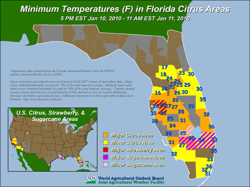
22
Maps of Daily Data Blue number = minimum temperature Red number = maximum temperature Green number = precipitation Agricultural Weather Assessments World Agricultural Outlook Board

23
Color Contour Maps Agricultural Weather Assessments World Agricultural Outlook Board

24
Color Contour Maps Agricultural Weather Assessments World Agricultural Outlook Board

25
Crop Moisture Index Agricultural Weather Assessments World Agricultural Outlook Board

26
MODIS Crop Condition Analyses Western Australia September 3, 2007 Western Australia September 2, 2008 Agricultural Weather Assessments World Agricultural Outlook Board

27
MODIS Winterkill Analyses Agricultural Weather Assessments World Agricultural Outlook Board

28
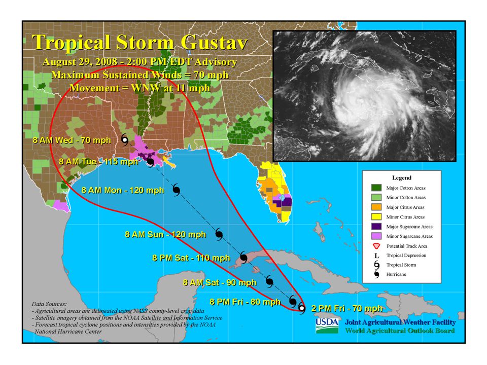
real power in GIS is ability to overlay and analyze multiple data sets… Overlaying & Analyzing Data Agricultural Weather Assessments World Agricultural Outlook Board

35
Thank You ! Agricultural Weather Assessments World Agricultural Outlook Board

Similar presentations