Download presentation
Presentation is loading. Please wait.

1
RIVER FORMATION EARTH’S GRAVITATIONAL FORCE PULLS OBJECTS TOWARD IT’S CENTER OF MASS. WATER FALLING DOWN A SLOPE IS EVIDENCE OF GRAVITY. AS OBJECTS DROP TO EARTH’S SURFACE, THEY PICK UP SPEED. WHEN WATER FALLS DOWN A SLOPE, IT PICKS UP SPEED.

2
IN THIS SECTION WE WILL LEARN HOW A RIVER FORMS.
RIVER FORMATION IT’S ENERGY OF MOTION IS MUCH GREATER, AND IT CAN ERODE MORE QUICKLY THAN SLOW MOVING WATER. IN THIS SECTION WE WILL LEARN HOW A RIVER FORMS.

3
FACTORS AFFECTING RUNOFF OF WATER
1. THE AMOUNT OF RAIN. 2. THE TIME SPAN OVER WHICH THE RAIN FALLS. 3. SLOPE OF THE LAND. 4. THE AMOUNT OF VEGETATION. 5. WHAT TYPE OF SOIL IT RUNS ACROSS.

4
RILL EROSION BEGINS WHEN A SMALL STREAM FORMS DURING A HEAVY RAIN.
RILL AND GULLY EROSION RILL EROSION BEGINS WHEN A SMALL STREAM FORMS DURING A HEAVY RAIN. AS THIS STREAM FLOWS ALONG, IT HAS ENOUGH ENERGY TO CARRY AWAY PLANTS AND SOIL. THERE’S A SCAR LEFT ON THE SLOPE WHERE THE WATER ERODED THE PLANTS AND SOIL. IF A STREAM FREQUENTLY FLOWS IN THE SAME PATH, RILL EROSION MAY TURN INTO GULLY EROSION.

8
GULLY EROSION IN GULLY EROSION, A RILL CHANNEL BECOMES BROADER AND DEEPER. LARGE AMOUNTS OF SOIL ARE REMOVED TO FORM A GULLY. IF THE WATER CONTINUES TO FLOW FREQUENTLY THROUGH THE GULLY, IT WILL WIDEN AND DEEPEN EVEN FURTHER, EVENTUALLY FORMING A STREAM.

12
STREAM EROSION SOMETIMES WATER CONTINUES TO FLOW ALONG A DEPRESSION.
IT THEN BECOMES A STREAM. AS THE STREAM MOVES ALONG, IT CONSTANTLY PICKS UP SEDIMENTS FROM THE BOTTOM AND SIDES OF IT’S CHANNEL.

13
BECAUSE OF THIS, A STREAM CONTINUALLY CUTS A DEEPER AND WIDER CHANNEL.
STREAM EROSION WATER PICKS UP AND CARRIES SOME OF THE LIGHTWEIGHT SEDIMENTS, WHILE LARGE, HEAVY PARTICLES JUST ROLL ALONG THE BOTTOM OF A STREAM CHANNEL. ALL OF THESE DIFFERENT SIZED MATERIALS SCRAPE AGAINST THE BOTTOM AND SIDES OF THE CHANNEL, WHERE THEY CONTINUE TO KNOCK LOOSE MORE SEDIMENTS. BECAUSE OF THIS, A STREAM CONTINUALLY CUTS A DEEPER AND WIDER CHANNEL.

14
Valleys with very steep, almost vertical sides are called canyons or gorges.

15
Rivers move a great deal of material
Rivers move a great deal of material. The faster the water moves, the larger material that can be carried down stream.

16
Fast moving upstream portions can often move rocks and boulders.
Downstream portions usually only transport small silts and clays.

17
This process tends to sort materials by size.
Have you ever wondered why we have so much silt and clay in our soil?

18
The speed at which a stream flows will determine what size sediments it can carry
Fast moving water can carry larger sediments (duh) Big Small Slow Fast
 Big Small. Slow Fast.")
19
RIVER SYSTEM DEVELOPMENT
IF YOU HAVE A STREAM IN YOUR NEIGHBORHOOD, IT IS PART OF A RIVER SYSTEM. THE WATER IN THE STREAM CAME FROM RILLS, GULLIES, AND SMALLER STREAMS LOCATED UPSTREAM. WHERE SMALL STREAMS JOIN, A LARGER STREAM FORMS. FINALLY, THESE LARGER STREAMS MERGE, FORMING A LARGER BODY OF WATER CALLED A RIVER.

20
A stream or river can not cut its bed any lower than the body of water into which it flows.
As the stream approaches this base level, the slope and speed of the stream decrease.

21
The river channel becomes wider, deeper, and the volume is bigger as there are more tributaries contributing to the volume.

22
The river valley also changes at this point.
It becomes more open, more of a U shape with a wider river floor.

23
It also has the largest volume and a very gentle gradient.
The lower or downstream portion of the river is at its deepest, widest and slowest speed. It also has the largest volume and a very gentle gradient.

24
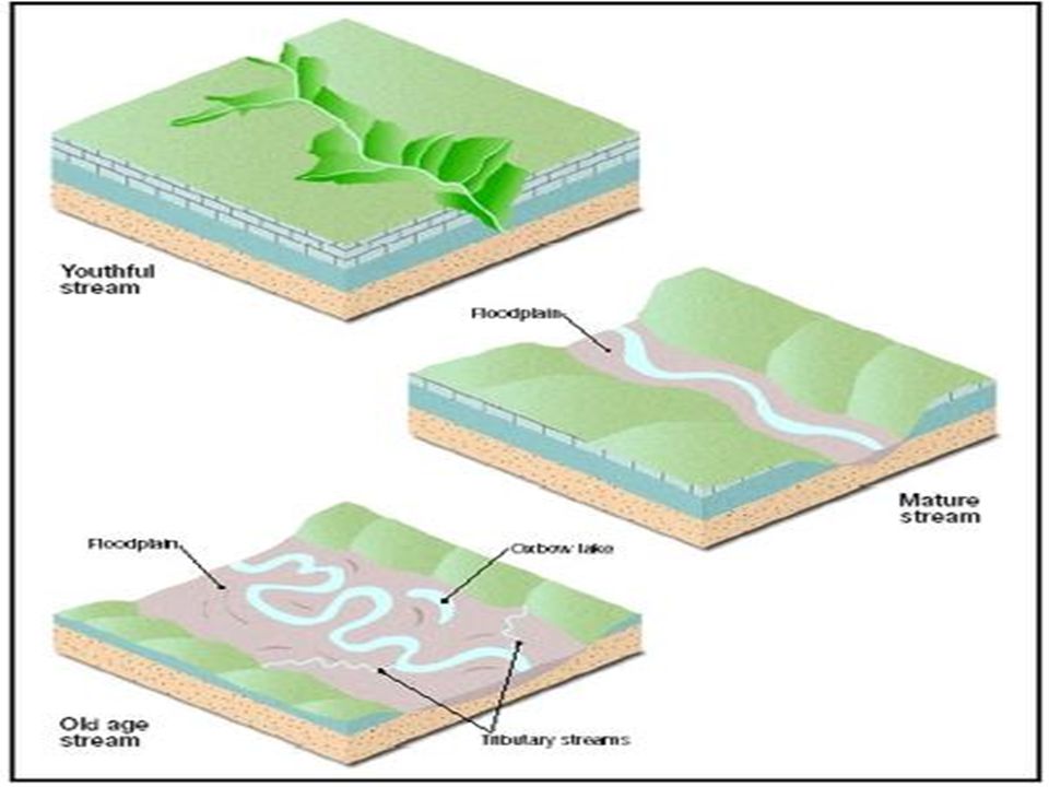
STAGES OF STREAM DEVELOPMENT
THERE ARE MANY DIFFERENT TYPES OF STREAMS. SOME ARE NARROW AND SWIFT MOVING, AND OTHERS ARE VERY WIDE AND SLOW MOVING. STREAMS DIFFER BECAUSE THEY ARE IN DIFFERENT STAGES OF DEVELOPMENT.

25
STAGES OF STREAM DEVELOPMENT
THESE STAGES DEPEND ON THE SLOPE OF THE GROUND OVER WHICH THE STREAM FLOWS. STREAMS ARE CLASSIFIED AS: 1. YOUNG 2. MATURE 3. OLD

26
STAGES OF STREAM DEVELOPMENT
THE STAGES OF DEVELOPMENT AREN’T ALWAYS RELATED TO THE AGE OF A RIVER. THE NEW RIVER IN WEST VIRGINIA, FOR EXAMPLE, IS ONE OF THE OLDEST RIVERS IN NORTH AMERICA. HOWEVER, IT HAS A STEEP VALLEY AND CASCADES THROUGH RAGING RAPIDS AND, AS A RESULT, IS CLASSIFIED AS A YOUNG STREAM.

27
Stream Development – Young Stage
Steep V-Shaped Valley Rapids and Waterfalls No Flood Plain Fast, high energy

28
As they flow they carve out a V-shaped valley
YOUNG streams flow over a steep gradient and tend to be relatively small.

29
Waterfalls indicate a YOUNG stream

31
Stream Development - Mature Stage
Lateral erosion widens the valley profile – slope decreases River meanders pronounced A FLOOD PLAIN develops

32
As the stream grows larger – it begins to shift its course in a series of bends or curves called meanders seeking out the lowest elevation

33
As time goes by, the stream erodes away the land and makes it flatter.
When the gradient is low, the shape of the stream changes and meanders form: MEANDER

37
Stream Development - Old Age
Very Wide Flood Plain Land worn down to flat surface Many Meanders, Oxbow Lakes

41
Eventually this meander gets so big and exaggerated that it is ‘cut off ’ from the stream.
However, the channel full of water is still there, so it becomes an OXBOW LAKE

44
Levee Formation

46
Contour lines showing head of the stream to the mouth of stream with delta
Velocity slows when entering a large body of water

47
Eventually all streams flow into the ocean
This part of a stream is called a DELTA Eventually all streams flow into the ocean

48
What is the correct sequence in stream development?

Similar presentations