Download presentation
Presentation is loading. Please wait.

1
IWMP Watersheds To be Implemented Under the New Common Guidelines, 2008

2
Evolution of Watershed Guidelines Prof. C.H. Hanumanth Rao Committee Guidelines 1995 Participatory & Integrated approach (1995-96 to 2001-02). Revised Guidelines 2001 Revised Cost norms 2002-2003. Hariyali Guidelines 2003 Implementation through GPs 2003-04 to 2007-08. Common Guidelines 2008 (Cluster Approach, Revised Cost Norms 1-4-2008)
. Revised Guidelines 2001 Revised Cost norms Hariyali Guidelines 2003 Implementation through GPs to Common Guidelines 2008 (Cluster Approach, Revised Cost Norms ).")
3
Key Features of New Common Guidelines 2008 Delegating powers to States. Dedicated institutions Professional teams at CLNA/SLNA/DWDU (DWMA) Financial Assistance to Dedicated Institutions. Duration of the Project 4-7 Years Preparatory phase, works phase & Consolidation phase. Provision for foreclosure of the Projects.
 Financial Assistance to Dedicated Institutions. Duration of the Project 4-7 Years Preparatory phase, works phase & Consolidation phase. Provision for foreclosure of the Projects..")
4
Key Feature (contd..) Livelihood Orientation Focus on NRM Based Livelihoods. Cluster Approach Geo-hydrological unit of 1000 to 5000 ha Cluster of Micro Watersheds. Scientific Planning. IT & Remote sensing inputs in planning. Focus on Capacity Building. Come into effect from 1 st April, 2008. Single programme IWMP.

5
Institutional Arrangements NRAA CLNA of MoRD, GoI SLNA of RD, AP DWDU (DWMA) PIA Watershed Committee SHGs & UGs NLDC TSU 4 subject specialists & support staff DSU one subject specialist & support staff GP Line Dept./ Autonomous Body / NGO /PRIs
 PIA Watershed Committee SHGs & UGs NLDC TSU 4 subject specialists & support staff DSU one subject specialist & support staff GP Line Dept./ Autonomous Body / NGO /PRIs")
6
NRAA to provide support in Process of preparation of strategic plans. Preparation of State specific Technical Manuals. Identification of Resource Organizations and establishing CB arrangements. Action Researches. Conducting studies, evaluation and impact assessment. Convergence of different schemes. Effective Co-ordination. Organizing workshops & conferences for information sharing. Technical knowledge inputs.

7
CLNA - Roles Budget allocation among states & ensure smooth flow of funds. Support CB programmes. Initiate IEC with modern IT inputs. Close monitoring through online systems. Evaluation studies, impact assessment. National / Regional workshops & seminars. Funding for CLNA from the respective departments.

8
National Level Data Center To extend, store and generate watershed & Land Resource data To collate summary data for the entire country Will be equipped with various GIS thematic layers & master data for integrated layers Will be able to support the district level planning & monitoring

9
State Level Nodal Agency Can be a Dept/Mission/Society/Authority. Central assistance will come directly to the account of SLNA. Will sign an MOU with CLNA. Will have a full time CEO (Govt Officer on deputation or Professionals taken on contract) Will have representatives from NRAA,CLNA, NABARD and from the State Line Depts. Team of 4 to 7 Professionals (Subject Specialists) to be inducted into SLNA.
 Will have representatives from NRAA,CLNA, NABARD and from the State Line Depts. Team of 4 to 7 Professionals (Subject Specialists) to be inducted into SLNA..")
10
Main functions of SLNA Prepare a Perspective and Strategic Plan for the state. Establish and maintain the SDC. Provide technical support to the DWDUs. Approve list of independent CB institutions. Approve PIAs identified by the DWDUs. Ensure regular and qauality on-line monitoring. Constitute panel of independent evaluators. Prepare State specific Process Guidelines.

11
DWDU ( DWMA) and its functions Separate unit with fulltime Project Manger and 3 to 4 subject matter specialists. Identify PIAs – Identify Watershed Clusters. Facilitate preparation of perspective plans and Annual Plans. Provide technical support to PIAs. Develop Action Plans for CB. Ensure smooth flow of funds. Close monitoring of the implementation processes. Facilitate convergence with other programmes. Establish and maintain DLDC.

12
Role of PRIs District Planning Committee will approve the perspective and Annual Action Plans. DPC will integrate the Watershed Development Plans with overall District Plans and oversee its implementation. ZP will govern the matters relating to the co-ordination of various sectoral schemes with Watershed Development Projects. Contd…….

13
Role of PRIs (Contd…) ZP will review the progress of implementation. Intermediate Panchayats Provide support to PIAs and GPs /WS Committees in technical guidance with their subject Matter Specialists. GPs will supervise, support and advise Watershed Committees.. Contd…….

14
Role of PRIs ( Contd…) Authenticate the accounts / expenditure statements. Maintain Assets register. Allocate usufruct rights to UGs / SHGs over the assets created.

15
Watershed Committee (WC) Grama Sabha will constitute WC. WC to be registered under the SR Act, 1860. Grama Sabha to elect / appoint chairperson of WC. WC to have independent rented office. Secretary of the WC will be a paid functionary. WC shall constitute SHGs & UGs. Bank Account to be opened for WC.

16
Project Period & Phasing 4 to 7 years depending on the need. Preparatory phase1-2 years. Watershed works phase2-3 years. Consolidation & withdrawal phase1-2 years Provision for fore closure.

17
Allocation of Funds Unit cost raised to Rs.12000/ha. Releases by GoI in three installments 20% along with sanction of project. 50% after completion of the preparatory phase and 60 expenditure of 1 st installment. 30% for the consolidation phase after 75% of the total released funds are spent.

18
Budget Component Admin. cost10% Monitoring 1% Evaluation 1% Preparatory Phase EPA 4% Institution & Capacity Building 5% DPR preparation 1% Watershed Works Phase WS works50% LH for asset less poor10% PE & EP13% Consolidation Phase 5% Total100%

19
Approval & Sanction of Projects DWDUs (DWMAs) to submit detailed Annual Action Plans by December to the SLNA. State will scrutiny and submit the Action Plans by February to the CLNA at GoI level indicating ongoing liabilities and new projects. CLNA will allocate funds to the States. SLNA will sanction projects to the Districts. CLNA (MoRD) releases funds directly to districts based on the sanctions given by SLNA
 releases funds directly to districts based on the sanctions given by SLNA.")
20
State Perspective Strategy Plan Total geographical area275.00 lakhs ha. Total area of identified Micro watersheds.158.29 lakh ha. Area already covered by RD & other Depts.47.91 lakhs ha. Balance area to be covered under IWMP110.38 lakh ha. Contd……

21
State Perspective Strategy Plan (Contd…) To cover in 2009-104.50 lakh ha. To cover in the balance XI plan period11.00 lakh ha. To cover in XII plan period24.91 lakh ha. To cover in XIII plan period24.33 lakh ha. To cover in XIV plan period22.49 lakh ha. Total projected cost (with allowance for increase in unit cost in future). Rs.16310.34 crores Proposed in SPSP for next 18 years.
. Rs crores Proposed in SPSP for next 18 years..")
22
Prioritization Process for selection of IWMP WS GoI indicated tentative allocation of 4.40 lakh ha. Proposed to take up one IWMP watershed in each of 110 DDP/DPAP blocks of 12 districts in 2009-10. In each DDP / DPAP blocks mandals were prioritized based on the criteria of GoI. PDs got these prioritized lists approved by the DRCs with few modifications. Contd…….

23
Prioritization Process for selection of IWMP WS (contd….) In the mandal prioritized (and approved by DRC) in each of the DDP/DPAP blocks, hydro geological units of 4000-5000 ha were delineated. The maps of these delineated clusters (IWMP Watersheds) were sent to PDs for incorporating GP Boundaries. Forest Areas. Areas already covered under watersheds. Certain basic data of the villages falling in these IWMP watersheds was obtained from PDs for PPRs.
 were sent to PDs for incorporating GP Boundaries. Forest Areas. Areas already covered under watersheds. Certain basic data of the villages falling in these IWMP watersheds was obtained from PDs for PPRs..")
26
Preliminary Project Report Contained the details of Agro climatic conditions. Land use pattern with areas. Soil types, Topography, Rainfall, Major Crops. Flood and Drought Occurrence. Soil erosion detail, Runoff intensity. Summary of present livelihoods and possible interventions. Wage employment status & Migration status. Ground water status; Drinking water availability & quality. Major crops & their Productivity & Expected Post Project Productivity.

27
IWMP watersheds sanctioned for 2009-10 110 IWMP Watersheds covering a total area of 4.73 lakh ha were sanctioned by GoI. The funds towards the part of 1 st installment are released to the DWMAs. DPRs need to be got prepared by end of January, 2010 to get the balance release of 1 st installment.

28
PIA It was decided to designate the MPPs (MPDOs) as PIAs. Project Directors were informed accordingly & requested to appoint MPDOs as PIAs.

29
Detailed Project Report Guidelines & Module for DPR preparation are developed. For each IWMP Watersheds, one senior & experienced TA will be allotted to be with the planning team. 110 senior TAs are identified & they will be trained from 2 nd to 7 th December. Consortium meeting is being convened on 1 st December, 2009 to seek their help. One day orientation is being planned for PDs and APDs of the 12 DDP/DPAP district. Contd..

30
Detailed Project Report (Contd….) Members of ROs will be trained in 2 nd week of December. Planning process will start in 3 rd week of December, and will be completed by 15 th of February, 2010. DPRs will be prepared village wise with UG wise sub plans and consolidated for each IWMP clusters. Each village may take 8-10 days and each cluster of 6 villages (average) may take 48-60 days.
 may take days..")
31
BROAD CONTENTS OF DPRs 1. Introduction of micro watershed/village 2. Base line Data- Demographic features Livestock details BPL status Operational Holdings Migration particulars Details of Community Based Organization Land features Details of CPR Crops & Cropping patters Soil classification & Erosion status Climate & Hydrological features Ground water status Irrigation facilities Status of water table Quality and availability of drinking water. Water budget. Details of livelihoods. 3. Problem Typology of the watershed 4. Planning Process 5. Action Plan for NRM,CB,PE&EP 6. Maps- Cadastral maps &Thematic Maps 6. Institutional Arrangements 7. Expected Outcome

32
STEPS IN PREPARATION OF DPR 1 Secondary data collection, preparations 2 Village meeting & Conduct of PRA techniques 3 Socio Economic Survey of all HHs in Watershed village 4 Problem Typology Analysis 5 Conduct of Participatory Net Planning 6 Productivity & Livelihoods planning exercise 7 Institutional & Capacity Building plan( (with support of Course Directors) 8 Mandal Level meeting for Convergence planning 9 Data Consolidation & Documentation of DPR 10 Conduct of Grama Sabha, Obtaining approvals, submission of DPR
 8 Mandal Level meeting for Convergence planning 9 Data Consolidation & Documentation of DPR 10 Conduct of Grama Sabha, Obtaining approvals, submission of DPR")
33
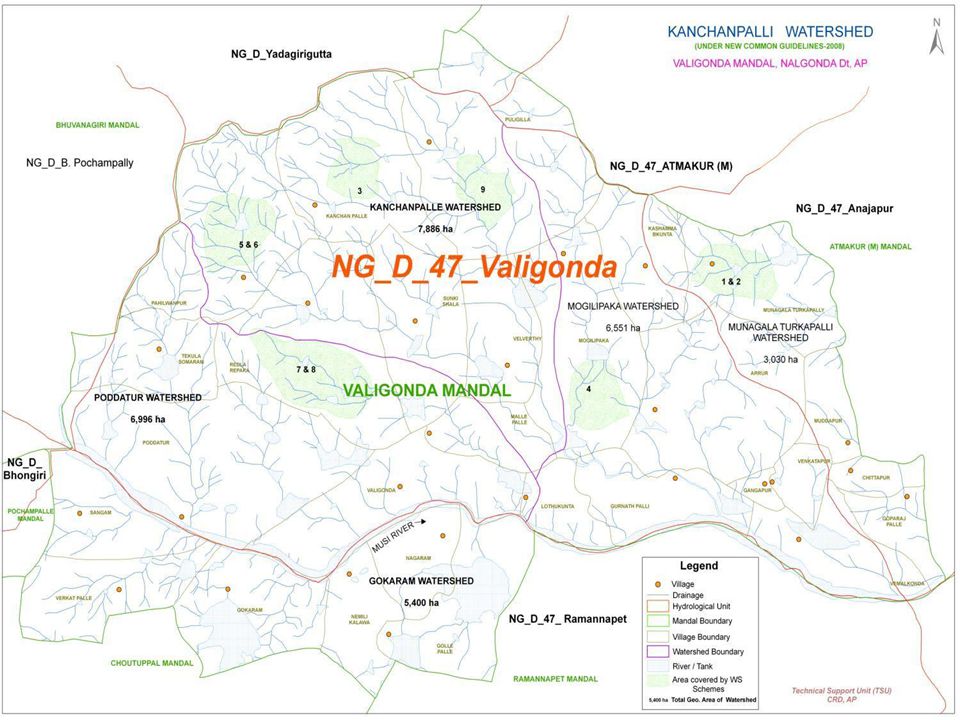
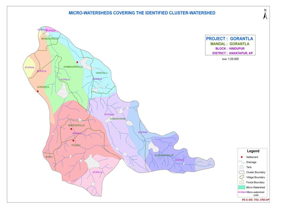
Maps The maps prepared for PPRs need to be revisited to make corrections where needed. Village boundaries & micro watershed boundaries need to be superimposed on them. These tasks will be completed in CRD Office by the GIS Cell. Contd…

34
Maps (Contd….) Thematic maps with following theme will be got prepared by APSARC or NRSA. Soil Resources. Land capability & Irrigabiity. Erosion status & Extent of soil loss. Geology and structure. Ground water potential zones. Slopes. Land use / land cover & NIDVI analysis. Long term rainfall analysis for rainfall Erosovity determination. Cadastral details superimposed on thematic maps.

35
Thank You

Similar presentations


 Power Finance Corporation Ltd. Restructured.>")


