Download presentation
Presentation is loading. Please wait.

1
TerraMod Basin Modelling Software DEMONSTRATIONOF RIFT MODELS

2
TerraMod Rift Modelling Event Types = –Deposition –Erosion –Thrust –Intrusion Simulates Most Geological Situations Optimisation Routines Assist Refinement of Geological Models

3
Double Click to Select Project

5
Create New Project: Choose Project Preferences

6
ProjectInformationDatabase

7
Customise Age Schemes Schemes

8
Customise Colour Schemes Schemes

9
Click on Lithotype Colour to Customise

10
Click on Lithotype Ornament to Customise

11
Click Once on a Well From this Well List to Open Well

12
Data Input Interface Built Around a Spreadsheet. Spreadsheet Builds into Database Architecture.

13
Add More Layers

14
Add More Layers by Tabbing Down or Using Mouse to Click on New Row Note Default Values for Many Parameters.

15
Select Geological Event Type for Each Layer Using Pop-Up Menu (Mouse Click).
.")
17
Use Age Scheme for Assistance with Entering Durations of Layers & Erosion Events and for Checking Model Integrity with Base Age Facility

18
View Base Age and Top Depth After Model Input is Complete to Check Model Integrity

19
Add Lithology to Layers Using In-Built 70 Lithotypes - Containing Lab. Derived Petrophysical Definitions of Most Major Lithologies.

22
Use Palaeo-Surface Temperature Graph to Estimate Surface Temperatures Through Time Associated with Palaeo-Latitudes.

23
Stratigraphic Column: Check Model Integrity - Displays Lithology, Layer Number, Layer Depth, Layer Age. Multiple Zoom Modes. Colour and Black & White Printing of Stratigraphic Column

24
Stratigraphic Column n Zoom In to Review Top Depths and Base Ages of All Layers n Check Integrity of Model at All Levels n Check Erosion Events Actually Erode the Correct Layers

25
n Zoom Out to Review More of the Model n Printable Stratigraphic Columns Available version 1.62

26
n Multiple Levels of Zoom Out

27
Source Rock Characterisation:: Source Rocks Are Characterised and Parameters Defined for Individual Layers. Each Parameter Critical to Volumetric Calculations Defined Separately Note: HC Volumes Calcuated From Net Source Prone Thickness.

29
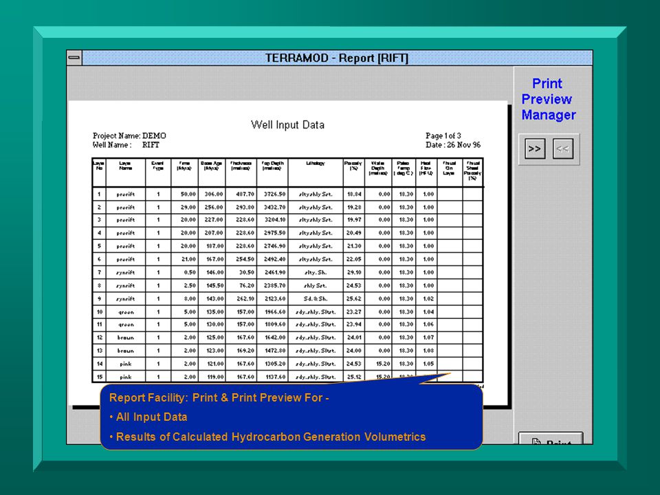
Calibration Data: Entered in User Friendly Spreadsheets Linked to Core Database.

30
Customisable Source Rocks & Kinetics:

32
Calibration Data:

33
Entered in User Friendly Spreadsheets Linked to Core Database.

34
Single Well Simulation Control Dialog: Select Number of Iterative Runs to be Made During the Simulation.

36
Gridding Parameters: Select Degree of ‘Fineness’ or ‘Coarseness’ for the Simulations (affects Finite Difference Gridding of Model).
.")
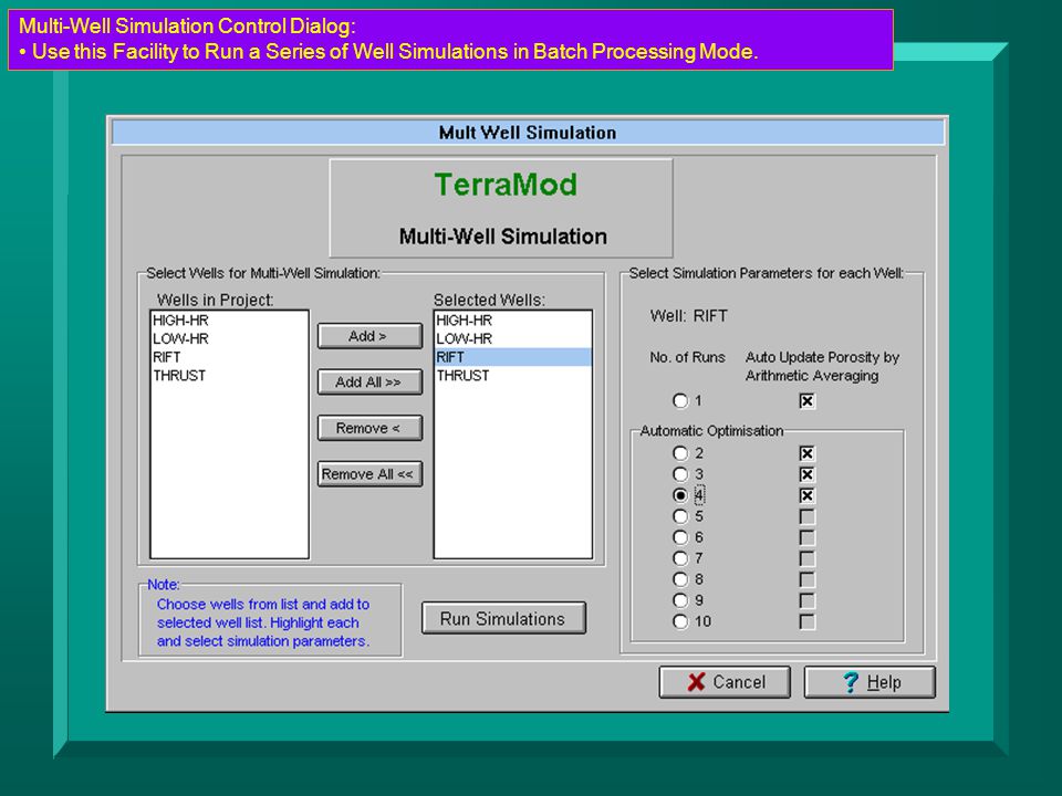
37
Multi-Well Simulation Control Dialog:

39
Simulation Tracking: Multi-Well Simulation Mode.

40
Illustrates the Processing Flow of the Simulation Algorithms & Gives Simulation Status.

41
Automatic Optimisation Procedures:

42
Simulation First Back-Strips Stratigraphy and then Makes a Forward Model

43
Automatic Optimisation Procedures: Simulation First Back-Strips Stratigraphy and then Makes a Forward Model First Check Calculated Thicknesses & Porosities Against Input Values

44
Automatic Optimisation Procedures: Simulation First Back-Strips Stratigraphy and then Makes a Forward Model First Check Calculated Thicknesses & Porosities Against Input Values

45
Central Manager for Screen Plotting & Printing: Set Up Printer Settings Once From Central Control Dialog Select Any Well From Project from Here Batch Printing Facility Available as Modular Upgrade.

46
Depth Plots Selection: Select Up To Two Plots to View Select ‘Time Slice’ to Review Select Manual Depth Scale on Y-Axis for Comparitive Plots.

48
Model Results Are Reviewed on Screen Plots Calibration Parameters are Reviewed in Depth Plot Facility to Check Model Integrity

49
Plots can Be Reviewed and Printed Independently

51
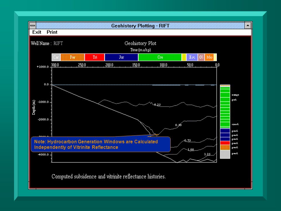
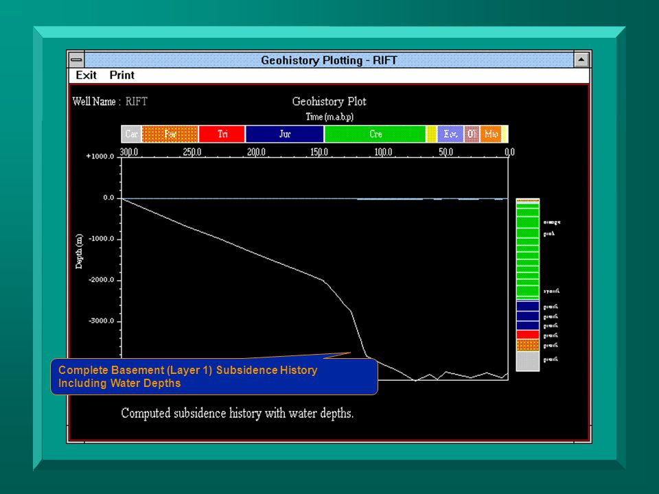
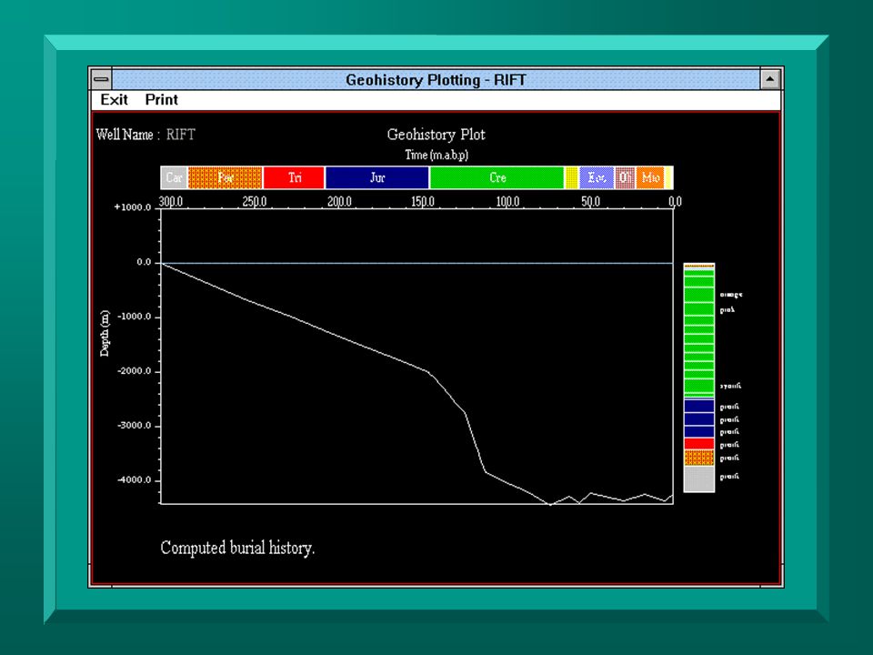
Comparison of Different Kerogens Maturity Windows for Type III Kerogen Calculate to be Deeper for Exactly the Same Model Input Parameters

53
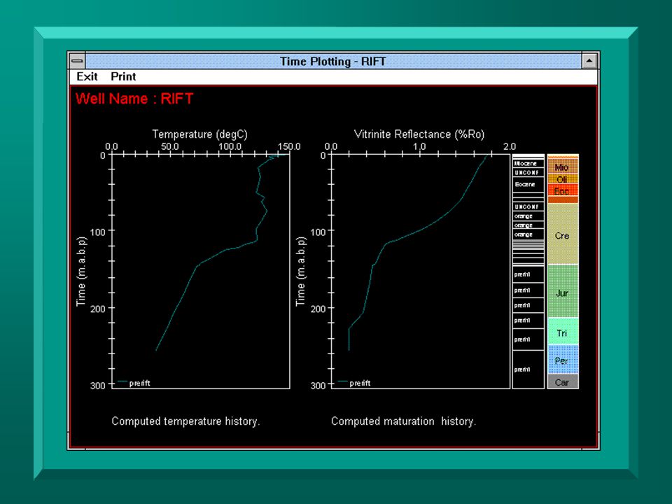
After Model Has Been Optimised With the Calibration Data and Re- Simulated Model Results Can be Used to Assess Petroleum SystemTime Plots:

54
Time Plot Control Dialog:

55
Normally Select One Layer at a Time to Review Development of Parameters Through Time.

56
Time Plot Control Dialog: Normally Select One Layer at a Time to Review Development of Parameters Through Time. Note: Auto-Scaling of Plots Can be Over-Ridden to Manual Scaling for Comparisons.

58
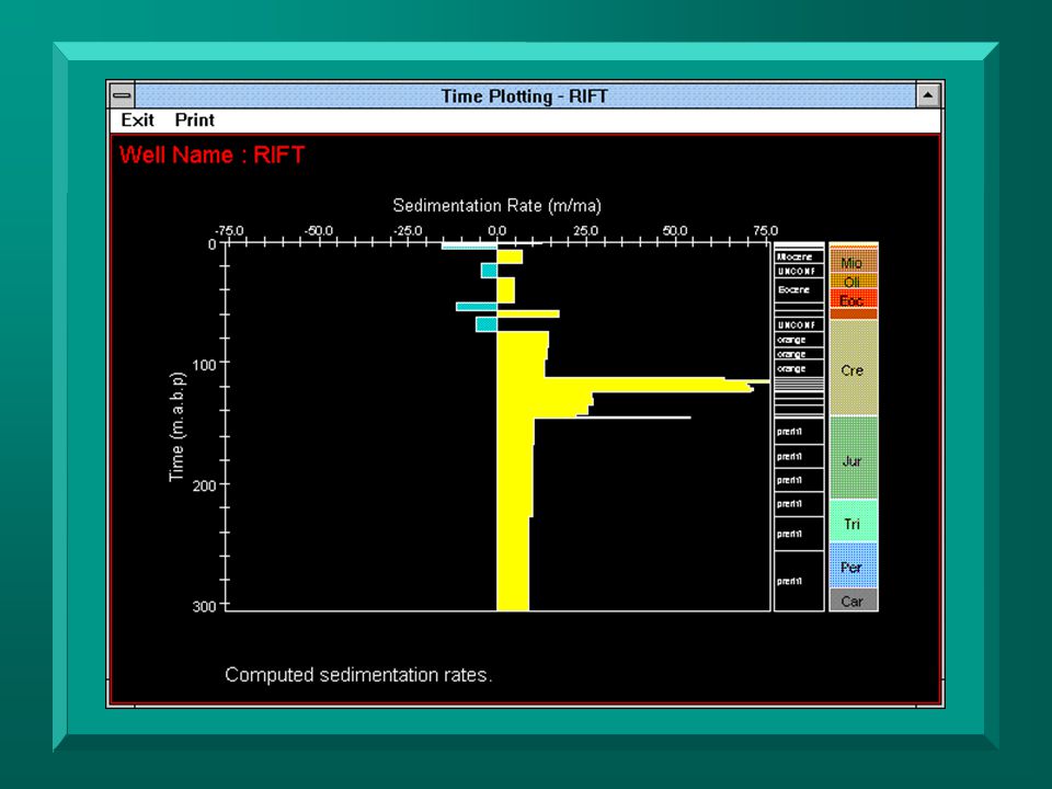
Calculated Sedimentation Rate: Very Useful for Checking Model Integrity Indicates Common Errors Introduced from Innacurate Assignement of Ages to Stratigraphic Layers (This is One of the Most Common Errors in Model Construction).
.")
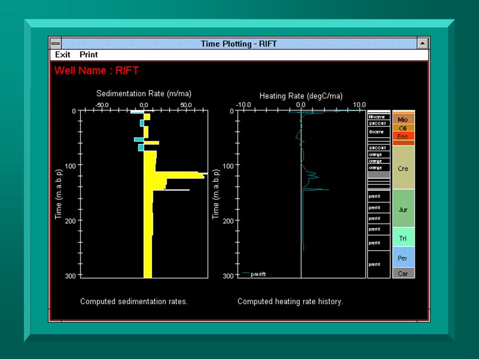
60
Heating rate and Sedimentation Rate Inter-Dependent variables Heating Rate Critically Affects Hydrocarbon Generation

Similar presentations