Download presentation
Presentation is loading. Please wait.

1
visualise | communicate | ENGAGE Instant Atlas™ is a registered trademark of GeoWise Limited ©Copyright 2008 | Geowise Limited IA Desktop to LIS Solution

2
visualise | communicate | ENGAGE Instant Atlas™ is a registered trademark of GeoWise Limited ©Copyright 2008 | Geowise Limited 1 st March 2005 InstantAtlas platform InstantAtlas improves the visual communication of location-based statistical data. Used by analysts, researchers, and information professionals who want to communicate quickly and effectively on the web with a customisable, off-the-shelf solution InstantAtlas brings your statistics to life and makes it easy for your audience to see regional, local patterns and trends Desktop Server Additional Modules

3
visualise | communicate | ENGAGE Instant Atlas™ is a registered trademark of GeoWise Limited ©Copyright 2008 | Geowise Limited 1 st March 2005 InstantAtlas Desktop Extends data visualization and presentation solutions for spreadsheets and desktop GIS software tools. Set of wizard-driven, easy-to-use, desktop tools for publishing and designing stand alone dynamic reports “Colourful eye-catching atlases, profiles, dashboards, performance reports and other graphics that aid presentation”

4
visualise | communicate | ENGAGE Instant Atlas™ is a registered trademark of GeoWise Limited ©Copyright 2008 | Geowise Limited 1 st March 2005 InstantAtlas Server Database-driven, web reporting solution Offers 'live' data delivery into InstantAtlas dynamic reports and data views Manage large volumes of indicators in a central database Share data loading internally and externally

5
visualise | communicate | ENGAGE Instant Atlas™ is a registered trademark of GeoWise Limited ©Copyright 2008 | Geowise Limited 1 st March 2005 Additional Modules Deliver flexible, text-based profiles Provide sophisticated user management and security deliver a complete information sharing and reporting framework Add the Spatial Server Module to: Deliver 'live' geographic data to dynamic reports Manage geographic data within a relational database Connect to existing GIS spatial data stores.

10
ADMINISTRATION LAYER

11
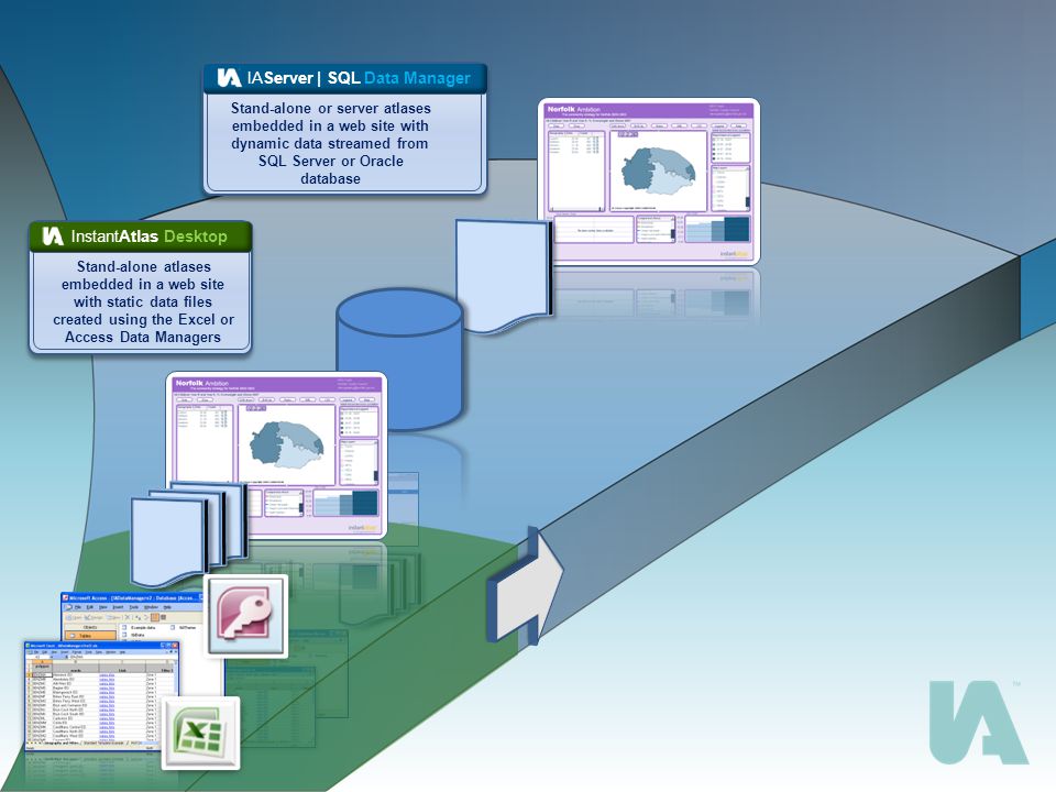
visualise | communicate | ENGAGE Instant Atlas™ is a registered trademark of GeoWise Limited ©Copyright 2008 | Geowise Limited 1 st March 2005 Solution Components IAServer | SQL Data Manager InstantAtlas Desktop Publisher Designer & Style Editor Templates Data Manager Excel Data Manager Workbook Data Server Administration

12
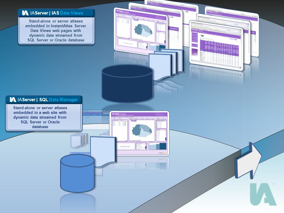
visualise | communicate | ENGAGE Instant Atlas™ is a registered trademark of GeoWise Limited ©Copyright 2008 | Geowise Limited 1 st March 2005 Solution Components IAServer | IAS Data views InstantAtlas Desktop Publisher Designer & Style Editor Templates Data Manager Excel Data Manager Workbook Data Server Administration Data views

13
visualise | communicate | ENGAGE Instant Atlas™ is a registered trademark of GeoWise Limited ©Copyright 2008 | Geowise Limited 1 st March 2005 Solution Components Local information system InstantAtlas Desktop Publisher Designer & Style Editor Templates Data Manager Excel Data Manager Workbook Data Server Administration Data views Combination of, or all of the other modules

14
visualise | communicate | ENGAGE Instant Atlas™ is a registered trademark of GeoWise Limited ©Copyright 2008 | Geowise Limited 1 st March 2005 IA Server: Available Modules 1.Administration (mandatory) 2.Reports 3.Advanced Reports 4.Data Views 5.Advanced Data Views 6.Spatial Server 7.Explorer 8.User Management
 2.Reports 3.Advanced Reports 4.Data Views 5.Advanced Data Views 6.Spatial Server 7.Explorer 8.User Management")
15
visualise | communicate | ENGAGE Instant Atlas™ is a registered trademark of GeoWise Limited ©Copyright 2008 | Geowise Limited 1 st March 2005 Key Benefits Effective communication and dissemination of data Administration tools gives you complete flexibility to mix and match indicator data and build dynamic atlases and area profile reports Meet different audience types Meet the needs of two ‘classic user groups’: (1)flexible tools for information professionals to search metadata, explore trends and patterns, create custom selections using filters and download datasets for offline analyses (2)pre-configured, tailored information products (profile reports and data views) for non-experts who need simple access to relevant facts and figures Modular approach Buy the modules you need now then simply add additional modules over time as use requirements evolve
flexible tools for information professionals to search metadata, explore trends and patterns, create custom selections using filters and download datasets for offline analyses (2)pre-configured, tailored information products (profile reports and data views) for non-experts who need simple access to relevant facts and figures Modular approach Buy the modules you need now then simply add additional modules over time as use requirements evolve")
16
visualise | communicate | ENGAGE Instant Atlas™ is a registered trademark of GeoWise Limited ©Copyright 2008 | Geowise Limited 1 st March 2005 Rapid delivery from an out-of-the-box solution If you have the data available and a suitable technical platform, then implementing the Data Server solution is achievable in weeks Improve the process of managing data Data Server helps improve your administration and data management processes by providing a tool for loading, storing and managing indicators in a central database Share the effort of loading and managing data Data loading and administration tools are accessible to anyone with access to the Internet. Trusted 'Content Administrators' can collate and load their own data through controlled processes that ensure it is validated before going live Key Benefits

17
visualise | communicate | ENGAGE Instant Atlas™ is a registered trademark of GeoWise Limited ©Copyright 2008 | Geowise Limited IAS multi-modular solution IAS database Admin Console Data Views IA Server IA Desktop Designer Excel Data Manager System or Data Administrators Dynamic report views Tabular views End users IA Server Modules Data file Area profile reports Reports Adv Reports Adv Data Views Explorer User Manager Spatial Server IAS Admin Console Spatial Database Other Business app Data Sources

18
visualise | communicate | ENGAGE Instant Atlas™ is a registered trademark of GeoWise Limited ©Copyright 2008 | Geowise Limited Delivering a complete solution: Our supporting services Consulting Implementation on-site System integration Training Support Managed Hosting Service National Stats Data Service

19
visualise | communicate | ENGAGE Instant Atlas™ is a registered trademark of GeoWise Limited ©Copyright 2008 | Geowise Limited 1 st March 2005 IA Server: Future Developments Some key enhancements planned for IA Server version 5: 1.Interface improvements (inc. continued support for web accessibility standards) 2.Tighter integration of Spatial Server as module of IA Server 3.Multi lingual capability 4.Support for Oracle Spatial 5.Improved data loading/integration capabilities (CLG PIE Hub, NeSS etc) 6.Easier customisation by customers – e.g. adding new pages 7.Improved area profile reporting with PDF outputs
 2.Tighter integration of Spatial Server as module of IA Server 3.Multi lingual capability 4.Support for Oracle Spatial 5.Improved data loading/integration capabilities (CLG PIE Hub, NeSS etc) 6.Easier customisation by customers – e.g. adding new pages 7.Improved area profile reporting with PDF outputs.")
20
visualise | communicate | ENGAGE Instant Atlas™ is a registered trademark of GeoWise Limited ©Copyright 2008 | Geowise Limited http://www.instantatlas.com/iads_solutions.xhtml

21
visualise | communicate | ENGAGE Instant Atlas™ is a registered trademark of GeoWise Limited ©Copyright 2008 | Geowise Limited 1 st March 2005 Questions? mahon.fitzgerald@geowise.co.uk pierre.jenkins@geowise.co.uk john.maslen@geowise.co.uk mahon.fitzgerald@geowise.co.uk pierre.jenkins@geowise.co.uk john.maslen@geowise.co.uk

22
IA Desktop to LIS Solution

Similar presentations


, that allows users to manage all Company,>")


