Download presentation
Presentation is loading. Please wait.

1
NOAA Data Center Access Activities via the GEOSS Architecture Implementation Pilot (AIP-2) Task AR-07-02 Glenn K. Rutledge NOAA / NCDC Co-Chair GEOSS AIP-2 Access Services Working Group George Percivall, Open GeoSpatial Consortium (OGC) Ken McDonald, NOAA / NESDIS January 7, 2009 ESIP Winter Meeting Access Tools for Targeting Environmental Information Users
 Ken McDonald, NOAA / NESDIS January 7, 2009 ESIP Winter Meeting Access Tools for Targeting Environmental Information Users.")
2
Outline GOESS AIP-2 Overview AIP-2 Access Services Status Report / Clearinghouse WG NOAA components and services in GOESS registries some access goals a community broker service: THREDDS, OPeNDAP, and the I/O-SP select NOAA entries in data directories registered in GEOSS a community of development: an example

3
The GEOSS Architecture Implementation Pilot task aims to incorporate contributed components consistent with the GEOSS Architecture, using a GEOSS Web Portal and a GEOSS Clearinghouse search facility, in order to access services through GEOSS Interoperability Arrangements in support of the GEOSS Societal Benefit Areas. Task AR-07-02 is conducted by the GEO Architecture and Data Committee. The GEOSS Pilot is part of the Architecture Implementation PilotArchitecture Implementation Pilot Task Lead: OGC (G. Percivall) GEOSS Architecture Implementation Pilot (AIP-2) Task AR-07-02
 GEOSS Architecture Implementation Pilot (AIP-2) Task AR")
5
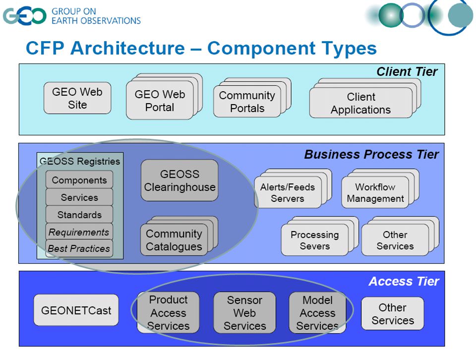
Components vs. Services A “GEOSS Component" is one of many earth observation resources that are contributed by a GEO Member or organization. –observing systems, data sets and products, catalogues, websites, models, training materials, or initiatives. –registered service interfaces can be defined and linked to a Component to explain access. A "GEOSS Service" describes a service interface to a component resource. –Typically an internet-accessible resource –interfaces promote the exchange of structured messages for the selection or processing of information. –These service interfaces ideally are associated with one or more GEOSS- registered standards to promote interoperability; –linkages identify the standard service protocol, data or metadata format, schema, and other criteria that will allow client software to use it. and the GEOSS Standards….

6
GEOSS Standards Registry http://seabass.ieee.org/groups/geoss/ GEOSS Interoperability Arrangements are either Standards or "Special arrangements". They are specifications that define a specific method for interoperability. WCS is an OCG Standard OPeNDAP is a special arrangement. NetCDF / CF is a community standard or Special arrangement GEOSS Interoperability Arrangements are listed in the GEOSS Standards Registry …. are listed in the GEOSS Standards Registry:

7
Access Services Transverse Use Case 1.Register Organization 2.Publish Component & Services 3.Publish Component Metadata System 4.Register Component & Services 5.Harvest by Clearinghouse 6.Test Registered Service 7.Search Clearinghouse 8.Search Community Catalog 9. Bind to Services 10. Access Services within Application 9. Evaluate GEOSS Resource 10. Register Standards & Best Practices 9. Bind to Alerts & Notifications 10. Publish Workflow 11. Subscribe to & Receive Alert Feed 9. Visualize & Analyze Data Registration: Critical 1 st step

8
NOAA’s entries in GEOSS Registry Quick “GEOSS Registry Service” search reveals: NOAA NGDC Space Physics Interactive Data Resource NOAA NGDC Simple NOAA Archive Access Portal Details NOAA NGDC Multibeam Bathymetry Web Map Service NOAA NGDC Global Historical Tsunami Web Map Service NOAA National Operational Model Archive and Distribution System (NOMADS) NOAA GOSIC Data Registry NOAA Global DART and Tide Gauge Data Web Map Service IOOS SOS at NOAA NDBC 8 not an automated process. What’s a component, What’s a service?

9
NOAA’s entries in GEOSS Registry (2) CLASS Comprehensive Large Array-data Stewardship System) NIDIS Portal NOAA Global DART and Tide Gauge Data NOAA NGDC Geomagnetic Data Services NOAA NGDC Global Historical Tsunami Event and Runup Databases NOAA National Data Buoy Center (NDBC NOAA National Operational Model Archive and Distribution System NOAA's National Climatic Data Center Radar Resources and Services North American Drought Monitor 9 Quick “GEOSS Registry Component” search reveals: How do users really find the data they need?
 CLASS Comprehensive Large Array-data Stewardship System) NIDIS Portal NOAA Global DART and Tide Gauge Data NOAA NGDC Geomagnetic Data Services NOAA NGDC Global Historical Tsunami Event and Runup Databases NOAA National Data Buoy Center (NDBC NOAA National Operational Model Archive and Distribution System NOAA s National Climatic Data Center Radar Resources and Services North American Drought Monitor 9 Quick GEOSS Registry Component search reveals: How do users really find the data they need")
10
AIP-2 Access WG The Access WG provides coordination and guidance to achieve interoperable Access Services to products, sensors and models. This relies on the AIP-2 particapants offerings and contributions to the pilot. By doing so, the Access WG contributes with the other WG’s to enable a Global EO System of Systems, through scenarios and use cases.

11
Template for Access Use Cases

12
Simple example

13
Common Data Model NetcdfDataset Application Scientific Datatypes NetCDF-Java version 2.2 architecture OPeNDAP THREDDS Catalog.xml NetCDF-3 HDF5 I/O service provider GRIB GINI NIDS NetcdfFile NetCDF-4 …your dataset Nexrad DMSP CoordSystem Builder Datatype Adapter ADDE Source: J. Caron/Unidata WCS GEOSS AIP

14
GEOSS Metadata Architecture The Services and Components Registry holds authoritative information about (mostly OGC) services. Maybe THREDDS & OPeNDAP. Community Catalogs hold dataset metadata. Registered as Catalog Service (CSW) NMMR Clearinghouse Extract information for FGDC Metadata Geospatial One-Stop 1) harvest or 2) distributed search Geospatial One-Stop NOAA Content: NOS Surveys: 11,779, NCDC: 466, NGDC: 413, NESDIS Products: 74, DART: 13 NCDDC: 6277, Coastal Data Information Program: 729 ISO 19119 MERMAid Source: T. Haberman NOAA
 NMMR Clearinghouse Extract information for FGDC Metadata Geospatial One-Stop 1) harvest or 2) distributed search Geospatial One-Stop NOAA Content: NOS Surveys: 11,779, NCDC: 466, NGDC: 413, NESDIS Products: 74, DART: 13 NCDDC: 6277, Coastal Data Information Program: 729 ISO MERMAid Source: T. Haberman NOAA.")
15
Goals for Catalogue - Clearinghouses Persistence, completeness, findability More resources and resource types, e.g. applications, workflows Minimum interoperability measures, e.g. geoss:Record Best practices for federated harvest and query User requirements refinement and added registry / clearinghouse value Controlled vocabularies, mediation resources, cross-community enablement On-going role for search and discovery in scenarios and decision support applications Facilitation of usable OpenSearch / GeoSearch entry points to the Clearinghouse Role for publish-subscribe-notify interaction style in Clearinghouse

16
16 Community Example: GeoNetwork GeoNetwork opensource is a standards based geospatial catalog application that helps people and organizations to organize and publish their geospatial data through the web. It is currently used in numerous Spatial Data Infrastructure initiatives across the world. (http://geonetwork-opensource.org)

17
AIP Clearinghouse etc. Clearinghouse, Catalogue, Registry, Metadata Working Group https://sites.google.com/site/geosspilot2/Home/clearinghouse- catalogue-registry-metadata ESRI ClearinghouseESRI ClearinghouseMarten Hogeweg Compusult ClearinghouseCompusult ClearinghouseRobert Thomas FGDC ClearinghouseFGDC ClearinghouseArchie Warnock NGDC / GMU Clearinghouse implementation Doug Nebert Co-chair FGDC Josh Lieberman Co-chair Kengo Aizawa Co-chair JAXA Ted Haberman Co-chair NOAA

18
ACCESS WG Contact Information Getting to the Access WG Web page: –http://sites.google.com/site/geosspilot2http://sites.google.com/site/geosspilot2 –Menu entry access-services-working-groupaccess-services-working-group Subscribing to the Access WG Mailing List: –https://lists.opengeospatial.org/mailman/listinfo/aip_accesshttps://lists.opengeospatial.org/mailman/listinfo/aip_access Access WG weekly telecons to discuss issues arising and new use cases that need to be addressed –Announcements through Access WG mailing list –ESIP Participants welcome! See Glenn Rutledge.

Similar presentations
 Doug Nebert U.S. Geological Survey February 5,>")


 WG Use Case Review Josh Lieberman GEOSS AIP-2 Design Review 2 December 2008.>")


 Phase 2 Air Quality and Health Working Group Stefan Falke, Rudy Husar, Frank Lindsay, David McCabe, Erin.>")

: status and evolution EC Side Event - GEO Plenary IX Foz do Iguacu, 22-23 November 2012 Mirko Albani Earth Observation.>")
>")
 Lead: Martha Maiden (NASA) Facilitate the development, availability and harmonization of data, metadata, and products.>")


 RFC GIS Workshop July 2007 NOAA/NESDIS/NGDC Documentation.>")
 Architecture Implementation Pilot (AIP) Air Quality and Health Working Group Stefan Falke, Rudy Husar,>")
 Architectural Framework Doug Nebert FGDC, U.S. Geological Survey February 2008.>")
