Download presentation
Presentation is loading. Please wait.

1
THE USE OF REMOTE SENSING DATA/INFORMATION AS PROXY OF WEATHER AND CLIMATE IN THE GREATER HORN OF AFRICA Gilbert O Ouma IGAD Climate Applications and Prediction Centre (ICPAC) Nairobi Formerly Drought Monitoring Centre - Nairobi (DMCN)
 Nairobi Formerly Drought Monitoring Centre - Nairobi (DMCN)")
2
Background The Horn of Africa is prone to extreme climate events such as droughts and floods with severe negative impacts on key socio-economic sectors Drought Monitoring Centre (DMC) in Nairobi and a sub-centre in Harare were established in 1989 by 24 countries in eastern and southern Africa under the auspices of WMO and UNDP –to minimize the negative impacts of extreme climate events –to take advantage of the good years
 in Nairobi and a sub-centre in Harare were established in 1989 by 24 countries in eastern and southern Africa under the auspices of WMO and UNDP –to minimize the negative impacts of extreme climate events –to take advantage of the good years")
3
Background Cont. due to the increased demand for climate information and prediction services, the Nairobi and Harare components started operating independently in 1998 –Drought Monitoring Centre, Nairobi (DMCN) GHA region –Drought Monitoring Centre, Harare (DMCH) Southern Africa
 GHA region –Drought Monitoring Centre, Harare (DMCH) Southern Africa.")
4
Background Cont. In 2000 DMCN was absorbed as an autonomous specialized institution of IGAD The name of DMCN was then changed to IGAD CLIMATE PREDICTION AND APPLICATIONS CENTRE (ICPAC) in order to properly reflect all its new mandates, mission and objectives within the IGAD system
 in order to properly reflect all its new mandates, mission and objectives within the IGAD system.")
5
ICPAC MEMBER STATES Sudan Djibouti Ethiopia Eritrea Somalia Kenya Burundi Rwanda Uganda Tanzania

6
Main Objectives To improve the technical capacity of producers and users of climatic information, in order to enhance the input to and use of climate monitoring and forecasting products in planning

7
Objectives Cont. To develop an improved, proactive, timely, broad-based system of information and product dissemination and feedback, at both sub-regional and national scales through national partners

8
Objectives Cont. To expand the knowledge base within the sub-region in order to facilitate informed decision making, through a clearer understanding of climatic and climate- related processes, enhanced research and development, and a well managed reference archive of data and information products

9
Mission of ICPAC Fostering sub-regional and national capacity for climate information, prediction products and services, early warning, and related applications for sustainable development in the IGAD Sub-Region

10
Products Monitoring of past climate –The recent past climate over the Horn of Africa is monitored in order to detect the evolution of any significant anomalies that could impact negatively on the socio – economic activities of the region Dekadal, monthly and seasonal summaries of rainfall and drought severity Monthly temperature anomalies –Given in bulletins

11
Products Cont. Current State of Climate –Monitored and assessed using climate diagnostics and modelling techniques –These are derived from: State of the Sea Surface Temperature anomalies over all the major oceans Surface and upper air anomalies of pressure, winds and other climate parameters

12
Products Cont. Prediction products –Derived from: Statistical and dynamical models run at the centre Dynamical model outputs from advanced centres –On dekadal, monthly and seasonal time scales The prediction products are provided through –Outlooks for dekads and months in bulletins –Seasonal outlooks in pre-season consensus climate outlook fora

13
Products Cont. Impacts –An assessment of the vulnerability together with the current and potential socio-economic conditions and impacts (both negative and positive) associated with the observed and projected climate anomalies is also made on a dekadal, monthly and seasonal time scales
 associated with the observed and projected climate anomalies is also made on a dekadal, monthly and seasonal time scales.")
14
Droughts

15
Floods

16
Products Cont. These products are disseminated to all National Meteorological and Hydrological Services of the participating countries to serve as early warning information to a variety of sectoral users of meteorological information and products including policy makers, planners, health, energy, agricultural and water resource sectors, farmers as well as research institutions among others

17
Climate Monitoring Climate monitoring process entails assessing the current climate conditions in relation to history Use historical data to develop basic statistics that form the basis for the assessment

18
Climate Monitoring Cont. Lack of long-term data (Rainfall and Temperature) over Somalia OLR –Available from 1974 –Poor spatial resolution –No proper ground-truthing over Somalia done yet
 over Somalia OLR –Available from 1974 –Poor spatial resolution –No proper ground-truthing over Somalia done yet.")
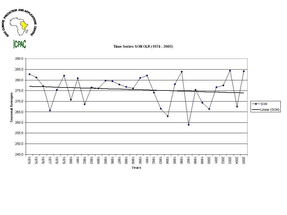
22
Fig. 8: Climatological OLR time series and trend analysis for Sool Plateau over the four traditional seasons

23
Climate Observation ICPAC works with the member countries to improve the climate observation network in the region in order to ensure availability of continuous high quality data that are required for climate change detection, attribution and other applications

24
Data for Climate Monitoring For purposes of climate monitoring, both historical and real-time daily data of rainfall, maximum and minimum temperatures are used For historical data, a base period of 30 years (1961-90) has been used to generate the desired statistics on a ten day, monthly and seasonal time scales
 has been used to generate the desired statistics on a ten day, monthly and seasonal time scales")
25
The historical climate data were obtained from the 10 National Meteorological and Hydrological Services of the participating countries in the Eastern Africa region The data is continuously updated –From the member states through email every ten-days –Through Capacity building workshops in which the National experts are mandated to bring their National data sets

26
Near real time climate data is acquired through a number of modes –Initially, fax and telephone services –Currently, most countries send through email For Somalia this has not been happening

27
Seasonal Forecast Use rainfall data from climatological regions in a country to locate highly correlated SST areas over the global oceans No data over Somalia Use proxy –OLR –RFE

Similar presentations


 www.icpac.net www.icpac.net Dept. of.>")


 June 28-July.>")

