Download presentation
Presentation is loading. Please wait.

1
Airport Obstruction Standards Committee (AOSC)
TERPS Airport Obstruction Standards Committee (AOSC) AC 150/ Change 9 and 10 Airport and Aeronautical Surveys Presentation to: Penn State Airports Conference, Hershey, PA. Name: Timothy Roe Date: 03/01/2006
 AC 150/ Change 9 and 10. Airport and Aeronautical Surveys. Presentation to: Penn State Airports Conference, Hershey, PA. Name: Timothy Roe. Date: 03/01/2006.")
2
Overview Introduction (Obligatory Joke) AOSC Overview
A shepherd was herding his flock in a remote pasture when suddenly a brand-new Ferrari advanced out of a dust cloud towards him. The driver, a young man in a Prada suit, Gucci shoes, Dior sunglasses and D+G tie, leans out the window and asks the shepherd: "If I tell you exactly how many sheep you have in your flock, will you give me one?" The shepherd looks at the man, obviously a yuppie, then looks at his peacefully grazing flock and calmly answers: "Sure. Why not?" Overview Introduction (Obligatory Joke) AOSC Overview TERPS Change 9 and 10 to AC 150/ Airport and Aeronautical Surveys Questions The yuppie parks his car, whips out his Dell notebook computer, connects it to his AT&T cell phone, surfs to a NASA page on the internet, where he calls up a GPS satellite navigation system to get an exact fix on his location which he then feeds to another NASA satellite that scans the area in ultra-high-resolution mode. The young man then opens the digital photo in jpeg format to AutoCAD d and exports it to an image processing facility in Hamburg, Germany. Within seconds, he receives an on his Palm Pilot that the image has been processed and the data stored. He then accesses a MS-SQL database through an ODBC connected Excel spreadsheet with hundreds of complex formulae. He uploads all of this data via an on his Blackberry and, after a few minutes, receives a response. Finally, he prints out a full-color,150-page report on his miniaturized HP LaserJet, turns o the shepherd and says: "You have exactly 1,586 sheep". “That's right. Well, I guess you can take one of my sheep," says the shepherd. He watches the young man select one of the animals and looks on amused as the young man stuffs it into the trunk of his car. Then the shepherd says to the young man: "Hey, if I can tell you exactly what your business is, will you give me back my sheep?" The young man thinks about it for a second and then says: "Okay, why not?". "You're a consultant," says the shepherd. "Wow! That's correct," says the yuppie. "But how did you guess that?" "No guessing required," answers the shepherd. "You showed up here even though nobody called you, you want to get paid for an answer I already knew, to a question I never asked, and you know nothing about my business. Now give me back my dog." The reason I like this story is it illustrates a point… no one knows your airport better than you!!!!
 AOSC Overview. TERPS Change 9 and 10 to AC 150/ Airport and Aeronautical Surveys. Questions. The yuppie parks his car, whips out his Dell notebook computer, connects it to his AT&T cell phone, surfs to a NASA page on the internet, where he calls up a GPS satellite navigation system to get an exact fix on his location which he then feeds to another NASA satellite that scans the area in ultra-high-resolution mode. The young man then opens the digital photo in jpeg format to AutoCAD d and exports it to an image processing facility in Hamburg, Germany. Within seconds, he receives an on his Palm Pilot that the image has been processed and the data stored. He then accesses a MS-SQL database through an ODBC connected Excel spreadsheet with hundreds of complex formulae. He uploads all of this data via an on his Blackberry and, after a few minutes, receives a response. Finally, he prints out a full-color,150-page report on his miniaturized HP LaserJet, turns o the shepherd and says: You have exactly 1,586 sheep . That s right. Well, I guess you can take one of my sheep, says the shepherd. He watches the young man select one of the animals and looks on amused as the young man stuffs it into the trunk of his car. Then the shepherd says to the young man: Hey, if I can tell you exactly what your business is, will you give me back my sheep The young man thinks about it for a second and then says: Okay, why not . You re a consultant, says the shepherd. Wow! That s correct, says the yuppie. But how did you guess that No guessing required, answers the shepherd. You showed up here even though nobody called you, you want to get paid for an answer I already knew, to a question I never asked, and you know nothing about my business. Now give me back my dog. The reason I like this story is it illustrates a point… no one knows your airport better than you!!!!")
3
Airport Obstructions Standards Committee (AOSC)
Chartered May 2003 The AOSC works across all FAA lines of business to transform outdated, inconsistent obstruction standards, and practices to future policy that optimally balances operational safety, effectiveness, and economic benefit

4
AOSC Steering Group Reports to Deputy Administrator, ADA-1 AOSC Steering Group Membership Ruth Leverenz, ARC-1 Kate Lang, ARP-1 (Acting) Russ Chew, ATO-1 Nick Sabatini, AVS-1
 Russ Chew, ATO-1. Nick Sabatini, AVS-1.")
5
AOSC Web Site - http://www.aosc.faa.gov/
Airports Rep Robert Bonanni (AAS-100) ATO Rep. Jesse Gaines (Terminal Safety and Operations Support)
 ATO Rep. Jesse Gaines. (Terminal Safety. and Operations. Support)")
6
AOSC Decision Documents
DD01 - POFA and Runway Separation, dated 12/18/03 DD :1 Departure Surface, dated 9/13/04 DD03 - Atlanta End-Around Taxiway (Departure Only), dated 7/12/04 DD04 - Runway/Parallel Taxiway Separation Standards , dated 3/21/05 DD05 - Airport Traffic Control Tower Interim Siting Guidance, dated 6/08/05 DD06 - DFW End-Around Taxiway(Departure Only), dated 6/08/05
, dated 7/12/04. DD04 - Runway/Parallel Taxiway Separation Standards , dated 3/21/05. DD05 - Airport Traffic Control Tower Interim Siting Guidance, dated 6/08/05. DD06 - DFW End-Around Taxiway(Departure Only), dated 6/08/05.")
7
Current AOSC Efforts End-Around Taxiways National Standards
End-Around Taxiways National Standards Departure Case Arrival Case? Updating Safety Assessment Toolset Airport Surveying-GIS Program NLA – TERPS Requirements Document 62.5:1 One Engine Inoperable (OEI) guidance
 guidance.")
8
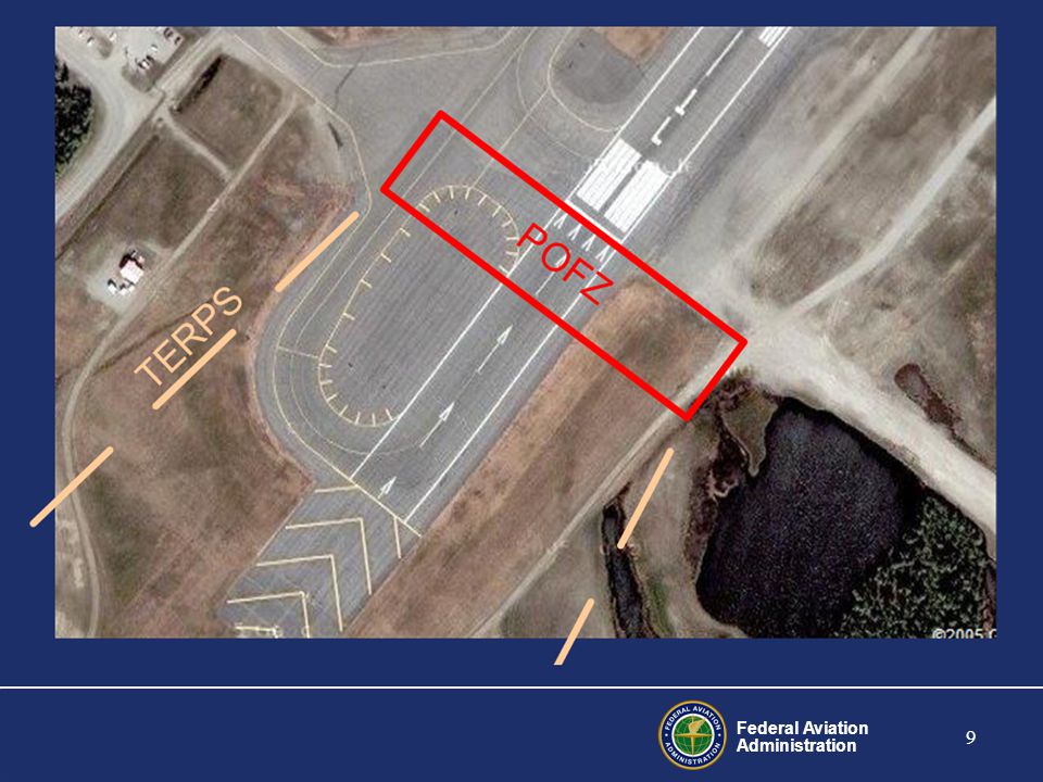
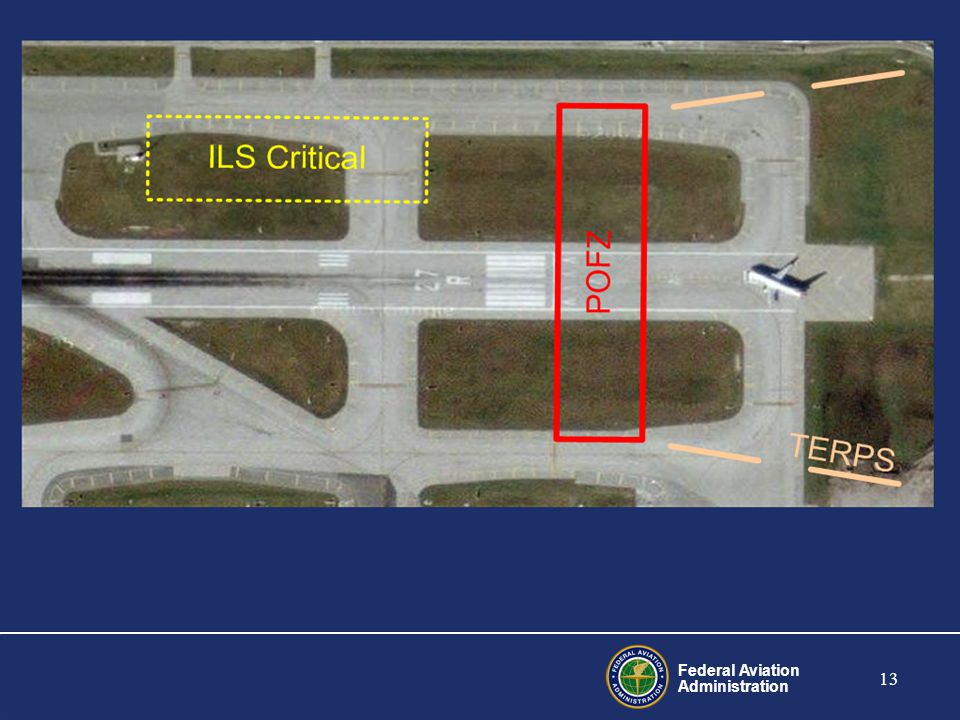
Decision Document 01 POFA and Runway Separation
POFA was renamed POFZ and included in Chg 8 to AC 150/ sent out September 30th, Same surface different name New POFZ marking/signage standards became effective December (Standard ILS Signs) FAA issued guidance for controllers to ensure POFZ is clear when weather is below 250 feet and ¾ mile and an aircraft is within 2 nautical miles final. POFZ is required no later than January 2007
 FAA issued guidance for controllers to ensure POFZ is clear when weather is below 250 feet and ¾ mile and an aircraft is within 2 nautical miles final. POFZ is required no later than January")
15
Decision Document #02 40:1 Departure Surface
Decision document #02 committed the Agency to… Establish a consistent 40:1 OCS standard Provide departure obstacle information to aircraft operators for all 40:1 penetrations Revise both the internal coordination procedures and the policy criteria governing the circularization process in the OE/AAA program. The 40:1 surface has been around for a long time for departures … the problem was how it was implemented was not consistent throughout the FAA DD 02 was implemented to correct this. Basically it involved where the surface started. In some cases (TERPS) it started at departure end at threshold elevation … however if there was a penetration they could raise the surface up to a height of 35 feet above threshold elevation OEAAA process always started the OIS at 35 feet. So obstacles were looked at differently.
 it started at departure end at threshold elevation … however if there was a penetration they could raise the surface up to a height of 35 feet above threshold elevation. OEAAA process always started the OIS at 35 feet. So obstacles were looked at differently.")
16
Change 9 to AC 150/5300-13 Does not take effect until January 1,2008
Added a New Departure Surface : Consistent with TERPS and FAR guidance Added to Appendix 2 Applicable to all instrument runways with departure procedures Added a New One Engine In-Operable(OEI) Survey Surface: Applicable at all runway ends used for air carrier departures Surface to be included in the ALP and made available to all air carriers at the airport Does not take effect until January 1,2008
 Survey Surface: Applicable at all runway ends used for air carrier departures. Surface to be included in the ALP and made available to all air carriers at the airport. Does not take effect until January 1,2008.")
17
Who knows your airport better than you??
AC 150/ Change 10 ARP will include 40:1 OCS clarification in change 10 of AC 150/ Departure Surfaces For Designated Runways The applicability of the surface table A2-1 is dependant on the designation of primary runway(s) for departure. The Airport Sponsor through ARP to the RAPT, will identify runway end(s) intended primarily for instrument departures. The determination of primary runway(s) for departure does not prohibit or negate the use of other runways . It only identifies the applicability of the A2-1 surface to the runway end(s). This is the new wording for Change 10 The key points are emphasized… It is the airport sponsor’s responsibility to identify which runway(s) will be designated as the primary departure runways Change 10 clarifies the criteria by not requiring every runway to be protected at 40:1 only those designated by the airport sponsor to the Regional/ADO office who will work with the RAPT to ensure appropriate choices are made based on ATC, Environmental, Airspace etc. Who knows your airport better than you?? Remove, relocate or lower (or a combination of relocate and lower) the object to preclude penetration of applicable siting surfaces unless fixed by function and/or designated impracticable. Within 6000’ of the table A2-1 surface origin, objects less than or equal to an elevation determined by application of the formula in the criteria
 for departure. The Airport Sponsor through ARP to the RAPT, will identify runway end(s) intended primarily for instrument departures. The determination of primary runway(s) for departure does not prohibit or negate the use of other runways . It only identifies the applicability of the A2-1 surface to the runway end(s). This is the new wording for Change 10. The key points are emphasized… It is the airport sponsor’s responsibility to identify which runway(s) will be designated as the primary departure runways. Change 10 clarifies the criteria by not requiring every runway to be protected at 40:1 only those designated by the airport sponsor to the Regional/ADO office who will work with the RAPT to ensure appropriate choices are made based on ATC, Environmental, Airspace etc. Who knows your airport better than you Remove, relocate or lower (or a combination of relocate and lower) the object to preclude penetration of applicable siting surfaces unless fixed by function and/or designated impracticable. Within 6000’ of the table A2-1 surface origin, objects less than or equal to an elevation determined by application of the formula in the criteria.")
18
40:1 Departure Surface No object should penetrate a surface beginning at the elevation of the runway at the DER or end of clearway and slopes at 40:1 . Penetrations by existing obstacles of 35 feet or less would not require TODA reduction or other mitigations found in the criteria - however, they may affect new or existing departure procedures.

19
OEI Departure Surface Departure Runway Ends Supporting Air Carrier Operations. Objects should be identified that penetrate a one-engine inoperative (OEI) obstacle identification surface (OIS) starting at the DER and at the elevation of the runway at that point, and slopes upward at a slope See figure A2-4. Note: This surface is for provided for information only and does not take effect until January 1, 2008.
 obstacle identification surface (OIS) starting at the DER and at the elevation of the runway at that point, and slopes upward at a slope See figure A2-4. Note: This surface is for provided for information only and does not take effect until January 1,")
20
Action Plan ARP: Develop guidance consistent with this decision ATO:
Action Plan ARP: Develop guidance consistent with this decision ATO: Work with airports to develop operational guidance using existing infrastructure (e.g., outer taxiways) AVS: Provide guidance to supercede TIL A and emphasize that draft TIL has been withdrawn Provide guidance to National Flight Procedures Group exempting the application of the above guidance during the bi-annual review process for existing procedures Update and refine the Safety Assessment Toolset Review standards based on updated toolset
 AVS: Provide guidance to supercede TIL A and emphasize that draft TIL has been withdrawn. Provide guidance to National Flight Procedures Group exempting the application of the above guidance during the bi-annual review process for existing procedures. Update and refine the Safety Assessment Toolset. Review standards based on updated toolset.")
21
Decision Document 04 Runway to Parallel Taxiway Separation
In support of Agency’s commitment to ensure safe precision approach and landing operations, policy clarification is needed, and the Airports Design A/C, TERPS and other guidance must be consistent (i.e., taxiing, parked and holding aircraft are obstacles)
")
22
Construction of New Runways/Parallel Taxiways
All CAT I operations 400 ft separation(500 ft for Group VI) CAT II/III Operations Groups I-IV aircraft ft separation Group V aircraft ft separation* Group VI aircraft ft separation* *if Airport elects to proceed with construction
 CAT II/III Operations. Groups I-IV aircraft ft separation. Group V aircraft ft separation* Group VI aircraft ft separation* *if Airport elects to proceed with construction.")
23
Existing Infrastructure
Existing Infrastructure The Agency will work with airports to develop operational guidance where compliance can be achieved utilizing existing infrastructure without significant impact on airport efficiency. Note that Airport improvement projects where a Draft Environmental Impact Statement was issued prior to approval of AOSC DD01 on December 18, 2003 will be treated as existing infrastructure.

24
Airport Surveying-GIS Program Overview
FAA Survey Initiative LPV (WAAS) Questions
 Questions.")
25
FAA Survey Initiative Airport Surveying-GIS Program (e-ALP)
Provide an interoperable web-based GIS system (Airports-GIS) for the collection, management, and maintenance of airport data addressing the needs of the FAA lines of business collectively rather than individually.
 for the collection, management, and maintenance of airport data addressing the needs of the FAA lines of business collectively rather than individually.")
26
Airport Surveying – GIS Program Purpose
Reduce the FAA’s use of NGS for field surveys and Transition the Survey to Private Contractors Allow surveys conducted by commercial enterprises/surveyors to use Federal Grants as well as other State & Local Aviation Resources. Standardize the Survey Process in a Cost-Effective and Expedited Manner Increase the Number of Surveys Conducted Annually Provide data for a standard GIS database capable of producing Digital ALPs and OC Drawings. This initiative is part and parcel of the Geo-Spatial One-Stop and the effort to centralize all geographic information developed or used by the government

27
Airport Surveying-GIS Program Objectives
Create a Standardized Process for Conducting Aeronautical Surveys – Advisory Circulars Create an Airport Geographic Information (GIS) System Website and Database Develop Technical Guidance, Instructions and Templates on contracting out and/or conducting Aeronautical Surveys for Airport Sponsors Develop Tools for Airports and Surveyors to Capture and Provide Survey Data in Digital Form (ADCAT Program) Consolidate all FAA Airport Data Requirements into a New Standard for Airport Layout Data to support FAA and Industry
 System Website and Database. Develop Technical Guidance, Instructions and Templates on contracting out and/or conducting Aeronautical Surveys for Airport Sponsors. Develop Tools for Airports and Surveyors to Capture and Provide Survey Data in Digital Form (ADCAT Program) Consolidate all FAA Airport Data Requirements into a New Standard for Airport Layout Data to support FAA and Industry.")
28
Aeronautical Surveys Airport Sponsor ADCAT Request E-NASR GIS Database
3rd Party Survey Airport Sponsor Request AIP Grant ADCAT Data Logger Checks and Formats Data Data Not Acceptable E-NASR GIS Database Data Acceptable NGS Validation NACO AVN

29
LPV Implementation FAA Program Goals Selection of R/W Ends
150 approaches to be implemented in FY-05, 300 approaches in FY 06, FY-07, FY-08 WAAS Office funds most surveys in FY-05, FY-06 ARP Survey Program transitions in FY-07 to fund surveys through third parties. Selection of R/W Ends Led by ATO and ARP Input from Airport Sponsors, and user groups

30
FY 07 and Beyond Runway ends surveyed by airport/contractor or NGS
Survey completed with Federal, state, and local funds at eligible airports Selection of R/W Ends Led by ARP and ATO Airport sponsor-driven process Input from WAAS Office, AVN, and AOPA

31
FY 07 LPV Implementation Criteria Used
Established by ARP with input from WAAS Office Requests from airport sponsor Guidance in Appendix 16 of AC 150/ Shown on ALP Availability of FY 06/07 funding to implement Environmental issues addressed Non-NPIAS airports not considered Submitted to RAPT (Regional Airspace and Procedures Team), including Airports Division
, including Airports Division.")
32
New Process: FY07 & Beyond
WAAS Program Goals Note: State grants, PFC, and local funding are also possible Airport Planning Process Survey AIP Grant Schedule Conduct This is the eALP Project Request Award Survey Survey Grant Obstruction Airports GIS Application Chart Data NGS Approach Data AVN Procedure Validation Aviation Systems Standards National Geodetic Survey -Processes controlled by FAA -Processes controlled by NGS -Processes controlled by the Airport

33
? Questions ? Robert Bonanni, P.E.
Office of Airports – Airport Engineering (AAS-100) Timothy Roe Innovative Solutions International Inc. supporting the Office of Airports - Airport Engineering (AAS-100)
 Timothy Roe. Innovative Solutions International Inc. supporting the. Office of Airports - Airport Engineering (AAS-100)")
34
Additional Material

35
What is WAAS? WAAS augments the GPS constellation to meet the necessary integrity, availability, accuracy, and continuity for use in all phases of flight at all runway ends

36
WAAS Components WAAS consists of: 25 reference stations
WAAS Components WAAS consists of: 25 reference stations 2 master stations 2 geosynchronous satellites 3 uplink stations

37
WAAS Capabilities Why invest in WAAS?
WAAS Capabilities Why invest in WAAS? Enhances en-route navigation performance over GPS alone Enhances non-precision approach capability over GPS alone Allows WAAS equipped users to fly 739 published LNAV/VNAV procedures to minimums as low as 350 feet Allows WAAS equipped users to fly new LPV procedures which provide precision approach capability to runways where there is no ILS. These can be flown to minimums to as low as 250 feet 100% Coverage CONUS & Alaska From 100,000 Ft. To Surface (LNAV) Horizontal Accuracy <1.5M Vertical Accuracy <3M Better Than 99.99% Availability Of System 95% Availability In CONUS Of Approach with Vertical Guidance 350’ Minimum WAAS Specific Approaches (LPV) Published Sep ’ Minimums
 Horizontal Accuracy <1.5M. Vertical Accuracy <3M. Better Than 99.99% Availability Of System. 95% Availability In CONUS Of Approach with Vertical Guidance. 350’ Minimum. WAAS Specific Approaches (LPV) Published. Sep ’ Minimums.")
38
Current LPV Approach Availability
Current LPV Approach Availability

39
Operational Benefits LNAV/VNAV 350’ LPV 250’ ILS 200’ 3o

40
The eALP Project ALPs contain a lot of information that is important to FAA What if… FAA could capture important information from the ALP and make it available electronically for whoever needs it? Airport Geographic Information Data Standard Replaces Appendix 15 in AC 150/ Industry Standards and Support Contents Features Attributes External Data Tables Imagery

41
eALP Applications Obstruction Evaluation Airport Airspace Analysis
Construction Projects Aviation Notices (NOTAM) Approach Procedures Environmental Analysis Airport Design Utility Management Wildlife Strikes Moving Maps Airport and System Planning NAVAID Establishment Ground Transportation Land Use Noise Monitoring Property Management FAA & Industry Publications ATCT Procedures Simulation & Training Pavement Management
 Approach Procedures. Environmental Analysis. Airport Design. Utility Management. Wildlife Strikes. Moving Maps. Airport and System Planning. NAVAID Establishment. Ground Transportation. Land Use. Noise Monitoring. Property Management. FAA & Industry Publications. ATCT Procedures. Simulation & Training. Pavement Management.")
Similar presentations


>")


>")
 September 8, 2011 Matt Cunningham, PLS Aviation Division Manager.>")

 for Aviation United Nations International Committee on GNSS 1 - 2 December, 2005 Ken Alexander United States.>")


 DAN HANLON WAAS PROGRAM MANAGER Tom Salat WAAS NAS INTEGRATION.>")


 2015 Annual Workshop Cindy.>")