Download presentation
Presentation is loading. Please wait.

1
United States of America

2
Regions of the United States The USA is divided into four different regions. They are the Southeast, Northeast, Midwest, and West. Because we live in South Carolina, our state is located in the Southeastern US.

3
Southeast Region The Southeast Region is made up of 16 states. Some of these states border the Atlantic Ocean and the Gulf of Mexico.

4
Northeast Region The Northeast Region is made up of 9 states. Some of these states border the Atlantic Ocean and Canada.

5
Midwest Region The Midwest Region includes 12 states. Some of these states border the Great Lakes and Canada.

6
Western Region The Western region includes 11 states. Some of these states border the Pacific Ocean and Canada. Hawaii lies to the west of this area in the Pacific and Alaska lies just North of this region.

7
Capital Cities Each state has a capital city where the central government of that state operates. For example, the capital of South Carolina is Columbia. Can you name the capital city of: Georgia? Atlanta North Carolina? Raleigh California? Sacramento

8
Games and Resources Place the state in the correct location on the map http://www.sheppardsoftware.com/USA_Geography/USA_G1_double2.html http://www.sheppardsoftware.com/USA_Geography/USA_G1_double2.html http://www.sheppardsoftware.com/states_experiment_drag- drop_Intermed_State15s_500.html http://www.yourchildlearns.com/mappuzzle/us-puzzle.html http://www.kidsgeo.com/geography-games/united-states-america-map- game.php Match the capital city to the correct state http://www.sheppardsoftware.com/USA_Geography/USA_1b_Caps_1280_8 00.html http://www.sheppardsoftware.com/USA_Geography/USA_1b_Caps_1280_8 00.html

9
Washington, D.C. Founded in 1791 and covers 68 sq. miles of land originally belonging to Maryland and Virginia. The name of our capital honors the first president, George Washington, while the District of Columbia honors Christopher Columbus. What places can you visit in Washington?

10
Washington Monument The Washington Monument was built between 1848 and 1884 as a tribute to George Washington's military leadership from 1775-1783 during the American Revolution. Its construction took place in two major phases, 1848-56, and 1876-84--a lack of funds, political turmoil, and uncertainty about the survival of the American Union caused the intermittent hiatus. The monument was damaged on Aug. 23, 2011 after a 5.8 magnitude earthquake caused 500 cracks in the obelisk. It was closed for renovations and opened up to the public once again on May 12, 2014. http://www.youtube.com/watch?v=rg omsxUVa2U&feature=youtube_gdat a_playerhttp://www.youtube.com/watch?v=rg omsxUVa2U&feature=youtube_gdat a_player stands 555' 5- 1/8" tall A slight color change is perceptible at the 150' level near where construction slowed in 1854. Text and photo from http://www.nps.gov/nr/travel/wash/dc72.htm

11
Lincoln Memorial Because of Lincoln’s work preserving the Union and the idea that all men are created equal, many people talked about the need to honor him in Washington with his own monument. In 1913, enough land was finally available and construction began the following year. During the Civil Rights movement, Dr. Martin Luther King, Jr. stood on the steps and addressed the public since the ideals of equality were exactly what Lincoln had fought for. Lincoln Memorial - Stories#/introductionLincoln Memorial - Stories#/introduction

12
Statue of Liberty "The Statue of Liberty Enlightening the World" was a gift of friendship from the people of France to the United States and is recognized as a universal symbol of freedom and democracy. The Statue of Liberty was dedicated on October 28, 1886. It was designated as a National Monument in 1924. http://www.nps.gov/featurecont ent/stli/eTour.htmhttp://www.nps.gov/featurecont ent/stli/eTour.htm

13
Census Data History of the census When the first decennial census of the United States was taken in 1790, the new nation was lightly populated, containing only a handful of port cities with more than 10,000 persons. In the two centuries since then, the nation's population has grown many times over, expanded westward, and become far more urban. The spread of cities across the American landscape is one of the more compelling stories of demographic growth and change. This series of 22 maps graphically presents this story. Population data were compiled for all incorporated places in the United States (and minor civil divisions in New England) containing at least 10,000 persons in any decennial census. Maps were then created for each decennial year 1790 through 2000, showing locations and size classes of those cities. When compared, the maps provide a fascinating visual representation of growth of American cities through time and changes in their distribution across the country. Census Data - 2010 Census Census Form http://2010.census.gov/2010census/text/text-form.php
 containing at least 10,000 persons in any decennial census. Maps were then created for each decennial year 1790 through 2000, showing locations and size classes of those cities. When compared, the maps provide a fascinating visual representation of growth of American cities through time and changes in their distribution across the country. Census Data Census Census Form")
14
The first census The census in 1830 after was taken in 1790 to the Missouri Compromise. determine representation.

15
The census taken prior to the Civil War. Census in 1910 before women got the right to vote.

16
Population http://2010.census.gov/2010census/data/

17
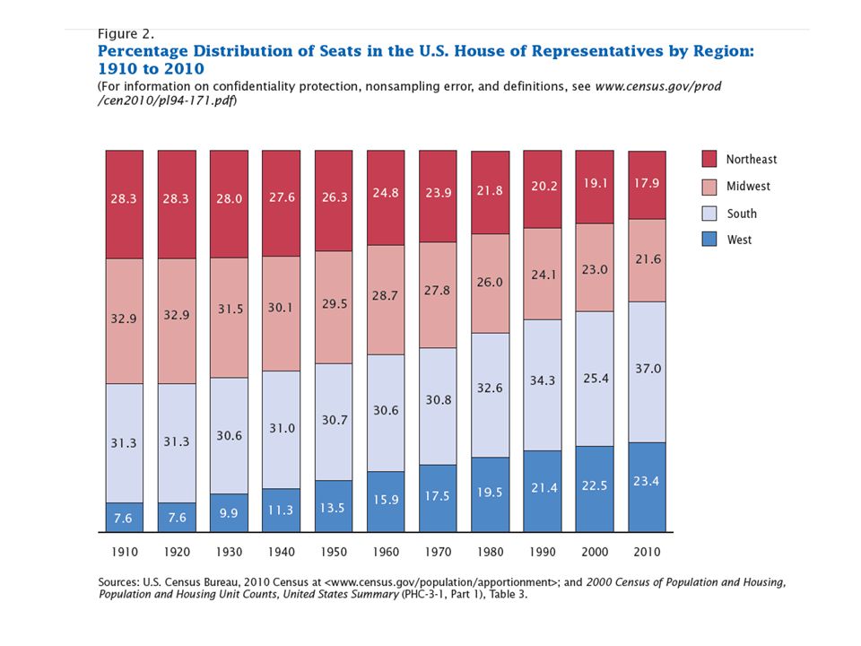
Apportionment Data Apportionment "Apportionment""Apportionment" is the process of dividing the 435 memberships, or seats, in the House of Representatives among the 50 states based on the population figures collected during the decennial census. The number of seats in the House has grown with the country. Congress sets the number in law and increased the number to 435 in 1913. The Constitution set the number of representatives at 65 from 1787 until the first Census of 1790, when it was increased to 105 members. http://2010.census.gov/2010census/data/

19
Table 5: Resident Population

20
Native American Indians

Similar presentations