Download presentation
Presentation is loading. Please wait.

1
Earth Science SOL General Overview

2
Astronomy Topics

3
Big Bang Theory Universe was at first a sphere of Hydrogen About 15 billion years ago it exploded Formed into a gigantic expanding cloud Continues to expand today (RED SHIFT)
")
4
Stars & Fusion Fusion is the act of combining 2 elements to form a new element Thermonuclear fusion uses very high temperatures to achieve fusion and releases energy in an uncontrolled manner

5
Stars & Gases Hydrogen is the most common element in stars The sun is powered by the fusion of Hydrogen into Helium (a Thermonuclear Reaction) Convection zones circulate the sun’s gases near its surface
 Convection zones circulate the sun’s gases near its surface")
6
Lifecycle of Stars Explosion forms a Nebula – a nursery for star formation (lots of gas and dust) Protostar – contraction of gases to form an early stage in a star’s life Main sequence Star - once the Protostar starts burning Hydrogen in its core, it becomes this Red Giant – a dying star Supernova – an explosion where the star is destroyed & it radiates extreme amounts of energy
 Protostar – contraction of gases to form an early stage in a star’s life Main sequence Star - once the Protostar starts burning Hydrogen in its core, it becomes this Red Giant – a dying star Supernova – an explosion where the star is destroyed & it radiates extreme amounts of energy")
7
Activities of the Sun Sunspots – cooler dark spots that are concentrated areas of magnetic fields Prominence - large, bright, gaseous loops extending from the surface, anchored to the Sun's surface in the photosphere, and extending outwards into the Sun's corona Solar Flare – violent eruptions of ions Solar Wind – the ions released by Solar Flares that react with Earth’s magnetic field Auroras – Solar Wind reacting with Earth’s ionosphere – produces Northern Lights (Aurora borealis)
")
8
Brightness & Temperatures of Stars H-R Diagram Luminosity

9
Spectrum Analysis This shows electromagnetic spectra that can be used to study emission and absorption lines given off by stars These lines are unique to each element and tells us the elements that make up each star

10
Our Sun Layers: Core – densest, center part Chromosphere – above the photosphere; gases moved by convection that transfer energy to the Corona Corona – outermost, visible portion of the sun

11
Solar Nebula Theory: Formation of our Solar System 1.) Cloud of very dense hydrogen gas collapses and begins the formation of a star 2.) Gravity & heat causes a spinning motion 3.) Heat in the areas closest to the star causes smaller, denser clumps to eventually form the rocky planets 4.) The cooler, outer areas form the larger, gaseous planets 5.) After about 100 million years, a solar system forms Everything is Revolving!
 Cloud of very dense hydrogen gas collapses and begins the formation of a star 2.) Gravity & heat causes a spinning motion 3.) Heat in the areas closest to the star causes smaller, denser clumps to eventually form the rocky planets 4.) The cooler, outer areas form the larger, gaseous planets 5.) After about 100 million years, a solar system forms Everything is Revolving!")
12
Our Solar System: Inner Planets Mercury 1 st Planet Covered with craters Almost no atmosphere Earth 3 rd Planet Covered with 71% liquid water Only planet with oxygen that supports life Has 1 moon Mars 4 th Planet Iron causes red color Thin CO 2 atmosphere Has 2 moons Venus 2 nd Planet Called Earth’s twin due to size & mass Very hot Dense atmosphere All Inner Planets are Rocky Inner Planets have few moons Inner Planets have shorter years.

13
Our Solar System: Asteroid Belt Separates the inner planets from the outer planets Positioned where another planet should be, but Jupiter’s gravity prevents it from forming

14
Our Solar System: Outer Planets Jupiter Largest planet No solid surface Made of liquid surrounded by gas Great Red Spot – huge storm lasting over 100’s of years Has a lot moons Saturn 2 nd largest planet It’s Density is lighter than water – it would float! Has rings made of lots of small particles Uranus 3 rd largest planet Spins on its side Has a methane atmosphere Neptune 4 th largest planet Is blue because of methane Has high winds Outer Planets are Gaseous, have many moons & have longer years.

15
What about Pluto? Found in our solar system after Neptune Dwarf planet Not large enough to be classified as a planet

16
Asteroids & Related Structures Meteoroid – debris outside of Earth’s atmosphere Meteor – debris within Earth’s atmosphere Meteorite - debris that has broken apart into smaller pieces before it reaches Earth’s surface Iridium in Earth Sediment Layers Asteroid – leftover debris from the formation of the solar system

17
Space Exploration History Sputnik 1957 – 1 st satellite (Soviet Union) Apollo Missions – Apollo 11 - 1969 – 1 st Moon Walk Space Shuttles – 1980’s Hubble Space Telescope (1990) – camera to take pictures of the universe Mars Landing – 1997; Mars pathfinder
 Apollo Missions – Apollo – 1 st Moon Walk Space Shuttles – 1980’s Hubble Space Telescope (1990) – camera to take pictures of the universe Mars Landing – 1997; Mars pathfinder")
18
Space Program Contributions GPS Cell Phone Telescopes Planetary Orbiters (Man-made satellites) Landers and Rovers
 Landers and Rovers")
19
Constellations & Galaxies Constellations Groups of stars that form patterns in the Earth’s sky that astronomers have named Galaxies Large groups of stars Bound together by gravity Approximately 100,000 light years in diameter Contains billions of stars, gas & dust Our solar system is in the Milky Way galaxy Spiral, Elliptical & Irregular Andromeda galaxy closest Examples: The Big Dipper (Ursa Major), the Little Dipper (Ursa Minor), Orion - Use of Parallax to tell distance
, the Little Dipper (Ursa Minor), Orion - Use of Parallax to tell distance")
20
Earth Moon & Sun Relationships: Eclipses Lunar Eclipse Solar Eclipse

21
Earth Moon & Sun Relationships: Tides Gravitational pull of the Moon and Sun cause the tides The highest high tides are called Spring Tides – sun, moon & Earth are lined up – largest pull of gravity The lower high tides are called Neap Tides – sun and moon are at right angles – less gravitational pull – lower water levels at high tide

22
Tide Table Most areas have 2 high tides & 2 low tides each day High tides occur every 12 hours & 25 minutes (same for Low tides)
")
23
Earth Moon & Sun Relationships: Moon Phases

24
Earth’s Tilted Axis The Earth rotates on an axis tilted 23.5 degrees. This causes the hemispheres to be at different angles to the sun at various times of the year, causing the seasons. In Winter, the sun’s energy travels through more atmosphere to reach the poles & is spread over a larger area of the Earth’s surface. Autumn/Fall Winter Spring Summer * Seasons shown are for the Northern Hemisphere. In Summer, the sun’s energy travels more directly to the Earth’s surface & doesn’t scatter as much in the atmosphere.

25
Meteorology Topics

26
Weather & Related Topics Humidity – amount of moisture in the air – Saturated – air holding as much moisture as it can Conduction – sun’s energy transferred between vibrating air molecules Convection – Circulating air – hot air rises, cools Convection & unequal heating causes winds High Pressure – Fair weather – clouds aren’t allowed to rise & form Low Pressure – Rain, Snow, Storms

27
Clouds Form when warm air rises, cools & condenses Classified by shape, height, rain capacity Shape – Stratus (smooth sheets at low altitude) = FOG Cumulus (puffy white high alt) Cirrus (high, thin wispy or feathery with ice crystals) Rain Capacity – Nimbus (dark & associated with precipitation)
 = FOG Cumulus (puffy white high alt) Cirrus (high, thin wispy or feathery with ice crystals) Rain Capacity – Nimbus (dark & associated with precipitation)")
28
Extreme Weather Hurricanes - tropical cyclone with winds of 120 kmph (75 mph) or higher Tornados – narrow, violent, funnel shaped winds Thunderstorms (hail) – heavy rain, thunder, lightning, sometimes hail Blizzards (snow, freezing rain, sleet) – produces a lot of frozen precipitation with cold temperatures
 or higher Tornados – narrow, violent, funnel shaped winds Thunderstorms (hail) – heavy rain, thunder, lightning, sometimes hail Blizzards (snow, freezing rain, sleet) – produces a lot of frozen precipitation with cold temperatures")
29
Weather Instruments Psychrometer Barometer Anemometer Weather Vane Rain Gauge Measures humidity Measures wind speed Measures atmospheric pressure Measures how much rain falls Measures wind direction

30
Fig. 18-3, p. 467 Atmospheric pressure (millibars) 0 Temperature 110 Thermosphere 65 100 1,000 90 55 80 70 Mesosphere45 60 35 50 Altitude (miles) Altitude (kilometers) 40 Stratosphere 25 30 20 Ozone layer 15 10 Pressure Troposphere 5 (Sea level) –80–40 0 4080120 Pressure = 1,000 millibars at ground level 200 120 75 0 Temperature (˚C) 400800600 Atmospheric Layers
 0 Temperature 110 Thermosphere , Mesosphere Altitude (miles) Altitude (kilometers) 40 Stratosphere Ozone layer Pressure Troposphere 5 (Sea level) –80– Pressure = 1,000 millibars at ground level Temperature (˚C) Atmospheric Layers.")
31
Other Important Things About Earth’s Atmosphere Ozone Layer – layer in the stratosphere that absorbs UV radiation Greenhouse Effect – traps heat to the Earth’s surface & keeps us warm What influences atmospheric temperatures in different regions on Earth? Latitude Elevation Bodies of Water

32
Air Masses Associated Words: Maritime – over or near water – moist air Continental – over or near land – dry air Tropical – warm Polar – cold Large bodies of air moving due to temperature & humidity differences TYPES of AIR MASSES: Maritime Tropical Continental TropicalContinental Polar Maritime Polar

33
Fronts Cold Front – violent storms Warm Front – usually fair weather Occluded Front – stormy weather Stationary Front – rain for long periods Boundaries between air masses of different densities & temperature – unstable weather

34
Mapping

35
Weather Map

36
Geology Topics

37
Rocks: Igneous Types: Extrusive – formed in lava, small crystals, glassy, cools quick – ex: Obsidian, Basalt, Pumice Intrusive – formed from magma, coarse, large crystals, cools slow - ex: Granite, Quartz Formed from cooling & hardening of magma and lava

38
Rocks: Metamorphic Types: Foliated (banded) – visible layers – Ex. Gneiss & Slate Non-Foliated (not banded)– no visible layers – Ex. Marble Formed when heat & pressure flattens existing rock
– no visible layers – Ex. Marble Formed when heat & pressure flattens existing rock.")
39
Rocks: Sedimentary Examples: many formed in Water Sandstone, Shale, Limestone, Conglomerate Formed from the compaction & cementation of sediments – usually in water Fossils are found in Sedimentary Rock. Clastic – made of large rock fragments glued together Non-Clastic – made of organic or chemical materials not glued together

40
The Rock Cycle Processes that occur in the Rock Cycle: Melting Weathering Compaction/Cementation Cooling/Hardening Heat/Pressure A continuous process in which rocks change from one type to another

41
IGNEOUS METAMORPHIC SEDIMENTARY Sediments Magma weathering compaction/cementation melting cooling/hardening melting heat/pressure

42
Minerals Structure Crystal Structure fast cooling = small crystals slow cooling = large crystals Elements Present Silicate (Silicon & Oxygen) Carbonate (Carbon & Oxygen) Formation Processes Cooling molten rock Evaporation of liquids Saturated solutions Examples Ores – mined for profit (ex. Iron) Gems – rare & valuable (ex. Rubies) A naturally occurring, inorganic substance with a definite structure and composition
 Gems – rare & valuable (ex. Rubies) A naturally occurring, inorganic substance with a definite structure and composition.")
43
Mineral ID Minerals are identified through various tests: o Color - least useful o Hardness - Moh’s Hardness Scale 1-10 (see table to right) o Streak – color left behind when rubbed on a porcelain tile o Luster - Shiny = Metallic or Dull = Nonmetallic o Breakage - Smooth surface = Cleavage or Jagged surface = Fracture
 o Streak – color left behind when rubbed on a porcelain tile o Luster - Shiny = Metallic or Dull = Nonmetallic o Breakage - Smooth surface = Cleavage or Jagged surface = Fracture")
44
Earth’s Major Elements & Minerals Oxygen Silicon Aluminum Iron Silicates Carbonates

45
Rocks and Minerals Important to Virginia Coastal Plain - - - - - - - - - Crushed Stone, sand, gravel and anything water Peidmont -- - - - - - - - - - - Kyanite Blue Ridge - - - - - - - - - - - Titanium Valley and Ridge - - - - - - -Limestone Plateau - - - - - - - - - - - - - Coal

46
Earth’s Layers The most dense layer is the Inner Core. Inner Core = solid, mostly Iron Outer Core = liquid, mostly Iron Crust is thinnest layer. Crust is rocky. Mantle is plastic (easily shaped or molded)
.")
47
Plate Tectonics – crust is broken into big pieces Plate Boundaries: Divergent – separating EX. Mid-Atlantic Ridge, Convergent – coming together EX. Mountains, Volcanoes, Trenches, Subduction zones Transform – side by side EX. Strike Slip Faults – San Andreas Fault Subduction Zone – collision of 2 plates where one plate slides beneath another plate (usually forms volcanoes or trenches) Crust Differences: Continental Crust – thicker, older, less dense Oceanic Crust - thinner, younger & denser Denser, oceanic crusts tend to subduct when they collide with the less dense, continental crusts. Plates move along faults (cracks in the crust) Plates move on top of the mantle due to Convection currents
 Crust Differences: Continental Crust – thicker, older, less dense Oceanic Crust - thinner, younger & denser Denser, oceanic crusts tend to subduct when they collide with the less dense, continental crusts. Plates move along faults (cracks in the crust) Plates move on top of the mantle due to Convection currents.")
48
Continental Drift – result of plate tectonics Evidence to support this: Fossil placement along edges of continents that were once attached Coal formation - Antarctica coal – had to be warm & wet in Antarctica in the past for the coal to form there Rock types match up along edges of continents that were once attached Seafloor Spreading rising magma forms new ocean floor & pushes existing floor outward Paleomagnetics – is the study of Earth’s magnetic field - shows reversed magnetic fields throughout Earth’s history - reversed poles Pangaea – single landmass that started breaking up 200 million years ago

49
Energy Transfer Hot material rises, cooler material sinks – causes a circulating current

50
Paleomagnetism, Divergent Boundaries & Mid-Ocean Ridges New ocean floor is created as magma rises through an Oceanic Divergent boundary at a Ridge in the crust Older crust is pushed away on either side of the Ridge New rocks formed on ocean floor The study of Paleomagnetism gives evidence for alternating Magnetism in the oceanic crust throughout Earth’s history on either side of the Ridge. North (+) & South (-) poles reversing periodically throughout time.
 & South (-) poles reversing periodically throughout time..")
51
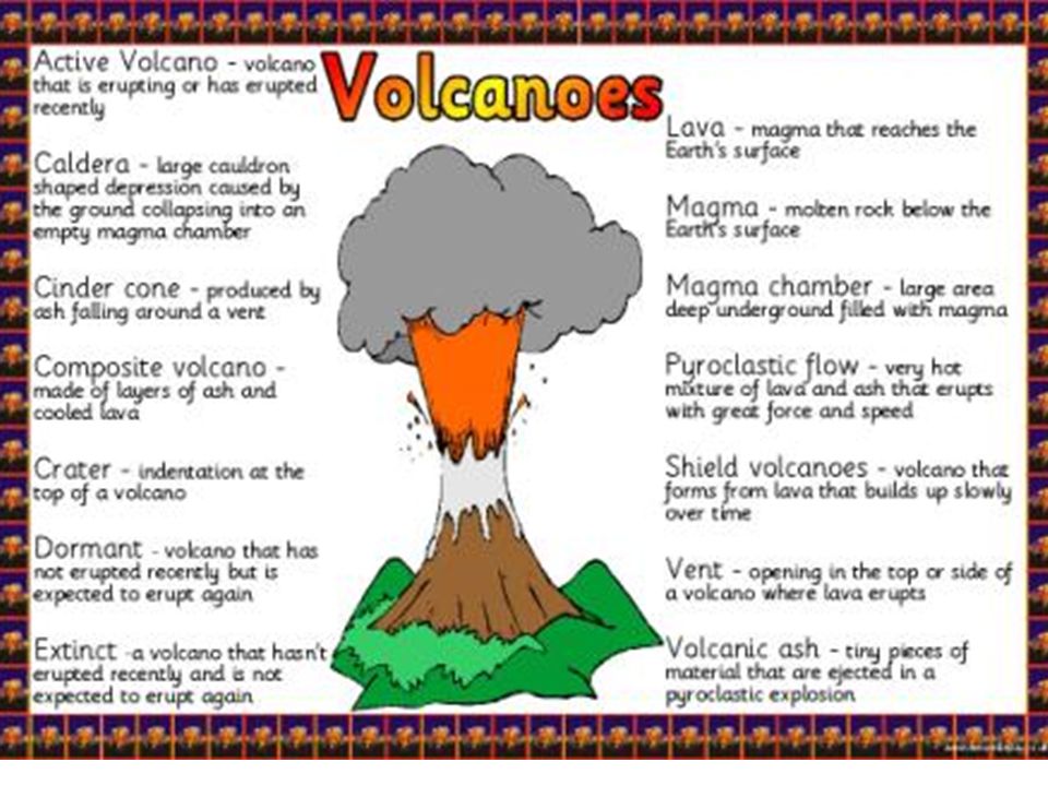
Volcanoes Volcanos form along Divergent boundaries (where Seafloor Spreading & Rifts occur) They also occur at Convergent boundaries (Subduction Zones) The Ring of Fire is a large area around the Pacific Ocean where plates are subducting & volcanoes are common Hotspots – are not due to plate boundaries but from a very deep magma source – the plates move over top of the magma source -Islands are formed here– Hawaii & Galapagos are examples Magma – molten rock under the Earth’s surface Lava – molten rock on the Earth’s surface
 They also occur at Convergent boundaries (Subduction Zones) The Ring of Fire is a large area around the Pacific Ocean where plates are subducting & volcanoes are common Hotspots – are not due to plate boundaries but from a very deep magma source – the plates move over top of the magma source -Islands are formed here– Hawaii & Galapagos are examples Magma – molten rock under the Earth’s surface Lava – molten rock on the Earth’s surface")
53
Crustal Movement Related to Earthquakes Stress builds between plates & when the plates overcome friction they move & release energy Stress Types – Compression - plates squeezed together Tension - plates being pulled apart Shearing - the lateral movement of plates sliding past one another Faulting & folding of rock results from stress. Faults – rocks move at breaks in the crust - Types of Faults: Normal Fault Reverse Fault Strike-slip Fault

54
Earthquakes Seismograph – an instrument that detects & records Earthquake waves Richter Scale – assigns a number to express the magnitude of energy released by an Earthquake Focus – where crust movement 1 st occurs Epicenter - point on surface directly above Focus Seismic Waves – energy release in wave motions in all directions from focus P-Wave – fastest, travels thru liquids, solids & gases S – Wave – second fastest, travels thru solids L – Wave – slowest, travels on surface, most destructive Earthquakes are associated with all plate boundaries

55
Virginia Provinces Coastal Plain – flat, young, sediments from eroded Appalachian Mountains Valley & Ridge– long parallel ridges & valleys with folded & faulted sedimentary rock Appalachian Plateau– rugged irregular sedimentary rock – formed from when Africa collided with N. American continent – most of VA’s coal comes from here Piedmont– rolling hills with igneous & metamorphic rocks Blue Ridge– very old igneous & metamorphic rocks

56
Topographic Features & Maps Topographic maps are 2 dimensional models depicting the geographic features of 3 dimensional landforms, such as mountains & sinkholes Karst Topography – related to structures created by dissolving limestone – examples include Caves & Sinkholes – these are common in the Valley and Ridge province of Virginia

57
Reading a Topographic Map

58
Geologic Time Exact age of rocks can be determined by Absolute Dating using Radioactive Decay or Half LIfe Earth is 4.6 billion years old We study rocks & fossils to figure out Earth’s history Relative Dating places an approximate sequence to events without assigning numerical ages – uses superposition Virginia has fossils found from the following geologic time eras: Paleozoic, Mesozoic and Cenozoic

59
Soils Soil is formed from weathering of rocks & organic activity Soil is composed of rock fragments and organic material Soil Layers (see picture to right) Soil Forming Processes… Weathering – wearing away & breaking down of rock by weather, water or chemical s Erosion – when sediments are carried away by wind or water Deposition – when sediments are dropped off in a location
 Soil Forming Processes… Weathering – wearing away & breaking down of rock by weather, water or chemical s Erosion – when sediments are carried away by wind or water Deposition – when sediments are dropped off in a location")
60
Fossils The remains, impressions or other evidence of preserved life Fossils show how life changes over time & shows how life has become more complex over time They can be preserved as molds, casts and original bone or shell Found in Sedimentary Rock (other rock type formations destroy fossils) Most fossils in Virginia are found in the Coastal Plain Most Virginia fossils are of marine organisms This indicates that large areas of the state have been periodically covered by seawater
 Most fossils in Virginia are found in the Coastal Plain Most Virginia fossils are of marine organisms This indicates that large areas of the state have been periodically covered by seawater")
61
Earth’s Water

62
Freshwater: Groundwater Freshwater is stored in permeable soil & rock underground Geologic processes such as erosion & human activity can pollute water supplies Freshwater is constantly being passed through the Hydrologic cycle (Water Cycle) Water table – area where the zone of saturation (pore spaces under ground filled with water) meets the zone of aeration (pore spaces underground filled with air) Aquifer – underground layer of water that can be accessed through a well Watershed systems in VA – lead to Chesapeake Bay, NC Sounds & Gulf of Mexico Watersheds are areas of land where waters drain to
 Water table – area where the zone of saturation (pore spaces under ground filled with water) meets the zone of aeration (pore spaces underground filled with air) Aquifer – underground layer of water that can be accessed through a well Watershed systems in VA – lead to Chesapeake Bay, NC Sounds & Gulf of Mexico Watersheds are areas of land where waters drain to")
63
Freshwater: Icecaps & Glaciers About 69% of Earth’s freshwater is trapped in Icecaps and Glaciers Sea levels rise when ice caps melts Sea levels drop when ice caps form Glaciers are large bodies of dense ice that constantly moves under its own weight over many years, often centuries Ice caps & Ice sheets are large bodies of ice, usually associated with the poles that don’t move

64
Earth’s Oceans Important source of food & minerals Method of transportation & recreation Ocean Algae are important as a source of atmospheric Oxygen Heat is stored in the ocean – land climates near the oceans are milder than inland climates Convection currents are a mechanism for energy transfer

65
Saltwater: Chemistry Salts are washed into the ocean from rocks and soils on land by rivers & streams Oxygen, nitrogen and carbon dioxide are important gases found in the ocean Salinity decreases with precipitation Salinity increases with evaporation Colder water has larger amount of gases than warmer waters

66
Saltwater: Tides & Other Info The Ocean is a large heat reserve. The stored heat drives much of earth’s weather. Tides are the periodic rise & fall of the water level caused by gravitational pull of sun & moon (see slide 21) Algae provides most of our atmosphere’s Oxygen Convection currents are the main mechanism for energy transfer in the ocean
 Algae provides most of our atmosphere’s Oxygen Convection currents are the main mechanism for energy transfer in the ocean.")
67
Saltwater: Waves Tsunamis are produced by Earthquake activity and are also called Seismic Sea Waves Parts of a Wave: Crest (highest point) Trough (lowest point) Wave Height (distance between crest & trough) Wave Length (distance between 2 crests) Waves are how energy is transferred in seawater Most waves are generated by wind
 Trough (lowest point) Wave Height (distance between crest & trough) Wave Length (distance between 2 crests) Waves are how energy is transferred in seawater Most waves are generated by wind")
68
Saltwater: Temperature Differences Surface water- warm water with sunlight where wind and waves mix the heat evenly Deep water – very cold water without sunlight Middle – between the mixed and deep layers – temperature changes rapidly (Thermocline) and there is little light
 and there is little light")
69
Saltwater: Currents Surface currents – created by wind, & can be affected by Earth’s rotation (Coriolis Effect). The presence of continents influence their paths There are large surface currents that carry warm water toward the poles and cold water toward the equator Deep currents – driven by gravity & density differences Cold & high salinity increases density of water making it sink Upwelling caused by winds & density currents. It brings cold, nutrient rich water from the deep to the surface

70
Saltwater: Ocean Floor These structures were created by tectonic processes & are mapped using satellite imagery: Mid-ocean ridges: new ocean floor forms; older floor is pushed away – creates a rift valley – deep crack runs thru the middle Trenches: long, narrow, steep sided channels (ex. MarianasTrench) Continental shelves: gently sloping edge of continent (underwater) Continental slopes: steeper slope that drops off from continental slope to deeper ocean Continental Rise: Rises above the true ocean floor. Abyssal plains: flat deep ocean floor Seamounts: underwater mountains
 Continental shelves: gently sloping edge of continent (underwater) Continental slopes: steeper slope that drops off from continental slope to deeper ocean Continental Rise: Rises above the true ocean floor. Abyssal plains: flat deep ocean floor Seamounts: underwater mountains.")
71
Human Impact on the Earth

72
Impacts on the Ocean Estuaries are areas like the Chesapeake Bay where freshwater and salt water mix Human activities have important consequences on the oceans Waste disposal, construction & agriculture affect water quality Pollution and overfishing can harm or deplete resources Chemical pollution and sedimentation are great threats to the well being of estuaries

73
Our Natural Resources Minerals are important to human wealth and welfare Clean water resources are renewable, but can be polluted by human activity Fossil fuels are non-renewable and cause pollution, but are cheap & easy to use once extracted VA non-renewable resources that can’t be replenished quickly are coal, silica for electronics, titanium for metallurgy, limestone for making concrete VA renewable resources are vegetation, sunlight and surface water

74
Impacts on our Atmosphere Man made chemicals have decreased the ozone concentration in the upper atmosphere, exposing the Earth to harmful UV radiation Stratosphere

75
Scientific Investigation

76
Determining Variables Independent Variable – The condition you have control over changing – you decide the conditions Dependent Variable – The condition that changes as a result of the Independent variable In a data table, the Independent Variable is usually the first column! In a data table, the Dependent Variable is usually the second column! On a graph, the Dependent Variable is on the Y-Axis! On a graph, the Independent Variable is on the X-Axis!

77
Tools for Taking Measurements Thermometer in degrees Celsius Measuring Volume in mL Determining Mass using a balance. Units in grams or mg

78
Drawing Conclusions

Similar presentations