Download presentation
Presentation is loading. Please wait.

3
Weather... You can’t see me, but you feel me, you can’t touch me, but I can touch you. I have been called the “Breathe of the Gods”, or the killer and giver of life, gentle and fierce, friendly and enemy, angry and happy. The Native Americans called me Moriah, and Snow Eater (Chinook). The Japanese call me Kaze and in Russia I am called Veter. I can shatter homes, or wake a child from a peaceful sleep or bring relief in times of need. I can spread the most dreaded diseases or bring a welcome freshness. What am I?
. The Japanese call me Kaze and in Russia I am called Veter. I can shatter homes, or wake a child from a peaceful sleep or bring relief in times of need. I can spread the most dreaded diseases or bring a welcome freshness. What am I .")
4
Weather is.... The current state of the atmosphere...what is happening right now

5
Main points to remember as we learn about weather: The sun warms the earth’s surface and therefore all the air above the surface The earth is warmed most at the equator and least at the poles---why? The air above land is warmed more quickly than air above water. Warm air expands and rises, creating an area of low pressure; cold air is dense and sinks, creating an area of high pressure

6
Weather Factors Weather: The state of the atmosphere at a specific time and place TEMPERATURE= the average motion of molecules ↑ TEMP= ↑ movement of molecules= feels hot ↓ TEMP= ↓ movement of molecules= feels cold

7
Air Pressure Warm air= expanding or rising air= leaves behind L pressure Cold Air=sinking air= leaves an area of H pressure

8
Wind Movement Uneven heating of the earth’s surface causes some areas to be warmer than others. As we know, warm always follows cold to share it’s warmth- when this happens in the atmosphere, wind happens!

9
What causes winds? A wind is a horizontal movement of air from a area of high pressure to an area of low pressure A wind is a horizontal movement of air from a area of high pressure to an area of low pressure It is this difference in pressure that makes the air move=wind It is this difference in pressure that makes the air move=wind Winds are measured by direction and speed The anemometer is the tool we use to measure this Wind chill= ↑ cooling the wind causes

10
Local Winds The land cools and heats faster than the ocean. Water holds heat longer than land, and takes longer to heat or cool. SEA BREEZE During the day, the land gets hotter faster than the water. The heated air rises, leaving behind an area of low pressure. Wind from the cooler sea blows in to take the place of that warmer air. These happen during the day!

11
Land Breezes At night the lands cools off faster than the sea. Cool air sinks creating an area of high pressure. Wind blows from the land to the sea.

12
Global Circulation and Wind Systems Solar energy is at its greatest around the equator---Why? Solar energy is at its greatest around the equator---Why?

14
Global Winds: Wind belts: Horse Latitudes= 30°N and S of equator =calm winds= worlds desert areas Jet Streams= 10km above the surface blow from the west to the east

15
Intense heat = Powerful CONVECTION Warm, moist air rises and leaves behind an area of low pressure. This is why most rain forests are found along equatorial regions. Warm, moist air rises and leaves behind an area of low pressure. This is why most rain forests are found along equatorial regions. That air rises until it reaches the top of the troposphere, where it can’t rise any further. That air rises until it reaches the top of the troposphere, where it can’t rise any further. It spreads out towards the polar regions HOT follows COLD wanting to share its warmth. It spreads out towards the polar regions HOT follows COLD wanting to share its warmth. As it spreads it begins to cool and sink-usually 30°N and S of the equator- sinking air produces an area of H pressure with dry conditions= desert regions on earth As it spreads it begins to cool and sink-usually 30°N and S of the equator- sinking air produces an area of H pressure with dry conditions= desert regions on earth

16
Some or the air moves back towards the equator as it sinks... Tradewinds: Where do you think they got their name? Who were these winds particularly important to?

17
There was an area that sailors avoided at all costs... THE DOLDRUMS... is the area around the equator where the wind completely dies out... which meant death as soon as the fresh water ran out.

18
Jet Streams About 10 km above Earth’s surface are bands of high- speed winds called jet streams About 10 km above Earth’s surface are bands of high- speed winds called jet streams Meteorologists use the location of some of the jet streams as an aid in weather forecasting Meteorologists use the location of some of the jet streams as an aid in weather forecasting Jet streams generally blow west to east Jet streams generally blow west to east Jet streams form at the boundaries of adjacent air masses with significant differences in temperature (polar region vs. Equator) Jet streams form at the boundaries of adjacent air masses with significant differences in temperature (polar region vs. Equator) Jet streams have a meandering shape Jet streams have a meandering shape
 Jet streams form at the boundaries of adjacent air masses with significant differences in temperature (polar region vs. Equator) Jet streams have a meandering shape Jet streams have a meandering shape.")
19
Jet Stream Example

22
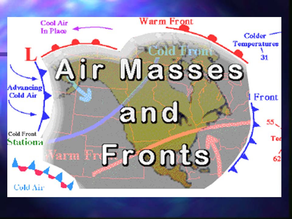
Air Masses A huge body of air that has similar temperature (warm or cold), humidity (dry or wet), and air pressure (high or low) at any given height is called an air mass A huge body of air that has similar temperature (warm or cold), humidity (dry or wet), and air pressure (high or low) at any given height is called an air mass Four major types of air masses influence the weather in North America: Four major types of air masses influence the weather in North America: Maritime tropical Maritime tropical Continental tropical Continental tropical Maritime polar Maritime polar Continental polar Continental polar
, humidity (dry or wet), and air pressure (high or low) at any given height is called an air mass A huge body of air that has similar temperature (warm or cold), humidity (dry or wet), and air pressure (high or low) at any given height is called an air mass Four major types of air masses influence the weather in North America: Four major types of air masses influence the weather in North America: Maritime tropical Maritime tropical Continental tropical Continental tropical Maritime polar Maritime polar Continental polar Continental polar")
23
Types of Air Masses Continental: land (dry) Continental: land (dry) Mar: sea (wet) Mar: sea (wet) Tropical: warm/hot Tropical: warm/hot Polar: cold Polar: cold The area that the air mass forms over will determine its characteristics The area that the air mass forms over will determine its characteristics For example: For example: If the source region is an ocean, the air mass will have a lot of moisture If the source region is an ocean, the air mass will have a lot of moisture If the source region is land, the air mass will be drier If the source region is land, the air mass will be drier
 Continental: land (dry) Mar: sea (wet) Mar: sea (wet) Tropical: warm/hot Tropical: warm/hot Polar: cold Polar: cold The area that the air mass forms over will determine its characteristics The area that the air mass forms over will determine its characteristics For example: For example: If the source region is an ocean, the air mass will have a lot of moisture If the source region is an ocean, the air mass will have a lot of moisture If the source region is land, the air mass will be drier If the source region is land, the air mass will be drier")
24
Putting it together Maritime Polar… Maritime Polar… Moist and cold Moist and cold Continental Polar… Continental Polar… Dry and Cold Dry and Cold Maritime Tropical… Maritime Tropical… Moist and warm Moist and warm Continental Tropical… Continental Tropical… Dry and warm Dry and warm

25
Air Masses and Their Origin Air Masses Origin Maritime Tropical Gulf of Mexico and Atlantic and Pacific Ocean Continental Tropical Southwest and Northern Mexico Maritime Polar North Pacific and North Atlantic Continental Polar Central and Northern Canada and Alaska

27
North American Air Masses 1 2 3 4 5 6

28
How Air Masses Move Prevailing Westerlies- push air masses west to east Prevailing Westerlies- push air masses west to east Jet stream Jet stream

29
Fronts The boundary where 2 unlike air masses meet is called a front The boundary where 2 unlike air masses meet is called a front 4 types of fronts 4 types of fronts Cold Cold Warm Warm Stationary Stationary Occluded Occluded Storms and changeable weather often develop along fronts Storms and changeable weather often develop along fronts

30
Symbols for Fronts

31
Occluded Front when a cold front overtakes a warm front A developing cyclone typically has a preceding warm front and a faster moving cold front. North of the warm front is a mass of cooler air that was in place before the storm even entered the region. As the storm intensifies, the cold front rotates around the storm and catches the warm front. This forms an occluded front, which is the boundary that separates the new cold air mass (to the west) from the older cool air mass already in place north of the warm front. Symbolically, an occluded front is represented by a solid line with alternating triangles and circles pointing the direction the front is moving. On colored weather maps, an occluded front is drawn with a solid purple line.
 from the older cool air mass already in place north of the warm front. Symbolically, an occluded front is represented by a solid line with alternating triangles and circles pointing the direction the front is moving. On colored weather maps, an occluded front is drawn with a solid purple line..")
32
Occluded Front when a cold front overtakes a warm front Changes in temperature, dew point temperature, and wind direction can occur with the passage of an occluded front. In the map below, temperatures ahead (east of) the front were reported in the low 40's while temperatures behind (west of) the front were in the 20's and 30's. The lower dew point temperatures behind the front indicate the presence of drier air.
 the front were reported in the low 40 s while temperatures behind (west of) the front were in the 20 s and 30 s. The lower dew point temperatures behind the front indicate the presence of drier air..")
33
Front Symbols and Direction Front symbols point in the direction of movement Front symbols point in the direction of movement Example: In the picture below, the warm, cold, and occluded fronts are moving north and the stationary front is not moving in any direction Example: In the picture below, the warm, cold, and occluded fronts are moving north and the stationary front is not moving in any direction

34
Front Symbols and Direction Draw a cold front moving east: Draw a cold front moving east: Draw a warm front moving south: Draw a warm front moving south: Draw an occluded front moving northeast: Draw an occluded front moving northeast:

35
Cold Fronts A cold front is when a fast-moving cold air mass takes over a warm air mass A cold front is when a fast-moving cold air mass takes over a warm air mass Possible weather: Clouds with possible thunderstorms with heavy rains or snow; cooler weather on the way Possible weather: Clouds with possible thunderstorms with heavy rains or snow; cooler weather on the way

36
Warm Fronts A warm front is when a warm air mass overtakes a slow-moving cold air mass A warm front is when a warm air mass overtakes a slow-moving cold air mass Possible weather: Humid, light rain or snow for several days; warmer weather on the way Possible weather: Humid, light rain or snow for several days; warmer weather on the way

37
Stationary Fronts A stationary front is when cold and warm air masses meet, but neither can move the other A stationary front is when cold and warm air masses meet, but neither can move the other Possible weather: The air masses remain stalled over an area and may bring many days of clouds and precipitation Possible weather: The air masses remain stalled over an area and may bring many days of clouds and precipitation

38
Occluded Front An occluded front is when a warm air mass is caught between two cooler air masses An occluded front is when a warm air mass is caught between two cooler air masses Possible weather: Cloudy and rain or snow Possible weather: Cloudy and rain or snow

39
Front Symbols on a Weather Map

40
Low Pressure and Weather If you look at a weather map, you will see areas marked with a letter L If you look at a weather map, you will see areas marked with a letter L and the L stands for “low pressure” Low pressure systems lead to cloudy conditions that often bring precipitation Low pressure systems lead to cloudy conditions that often bring precipitation Here’s how it works: Here’s how it works: Areas of low pressure are caused by massive amounts of air rising from the ground into the atmosphere Areas of low pressure are caused by massive amounts of air rising from the ground into the atmosphere As the air molecules rise, they take their mass with them As the air molecules rise, they take their mass with them –Air pressure is a force –Force = mass x acceleration –Less mass of air molecules left at ground level means low air pressure As this air rises it takes whatever water vapor it is holding along with it As this air rises it takes whatever water vapor it is holding along with it As altitude increases in the troposphere, the temperature decreases As altitude increases in the troposphere, the temperature decreases Eventually the air mass reaches a temperature at or below the dew point and the water vapor condenses Eventually the air mass reaches a temperature at or below the dew point and the water vapor condenses Relative humidity rises because colder air cannot hold as much water vapor Relative humidity rises because colder air cannot hold as much water vapor This condensation forms clouds This condensation forms clouds If there is enough water vapor in the air, it might also bring precipitation If there is enough water vapor in the air, it might also bring precipitation

41
High Pressure and Weather If you look at a weather map, you will see areas marked with a letter H If you look at a weather map, you will see areas marked with a letter H and the H stands for “high pressure” High pressure systems lead to clear and calm weather High pressure systems lead to clear and calm weather Here’s how it works: Here’s how it works: Areas of high pressure are caused by massive amounts of air sinking from the upper troposphere down towards the ground Areas of high pressure are caused by massive amounts of air sinking from the upper troposphere down towards the ground As the air molecules sink, they take their mass with them As the air molecules sink, they take their mass with them –Air pressure is a force –Force = mass x acceleration –More mass of air molecules coming to ground level means high air pressure As this air sinks it takes whatever water vapor it is holding along with it As this air sinks it takes whatever water vapor it is holding along with it As altitude decreases in the troposphere, the temperature increases As altitude decreases in the troposphere, the temperature increases The higher the temperature is, the farther from the dew point you get The higher the temperature is, the farther from the dew point you get Warmer air is less dense so it has more space to hold water vapor so relative humidity drops Warmer air is less dense so it has more space to hold water vapor so relative humidity drops This means that condensation does not occur so no clouds form This means that condensation does not occur so no clouds form Because there are no clouds, there will be no precipitation Because there are no clouds, there will be no precipitation

42
Weather Map Example

44
Water in the Atmosphere: Humidity Humidity: measure of the amount of water vapor stuck between molecules in the air. The air’s ability to hold water depends on the air temp The hotter the air, the more water the air can hold Cold air: molecules move slower so droplets of water can start to stick together=condensation Relative humidity: the amount of water vapor(%) compared to the amount the air can hold- tool used is a psychrometer. 100%=air is saturated
 compared to the amount the air can hold- tool used is a psychrometer. 100%=air is saturated.")
45
Air masses are masses of air that have the same characteristics of the surface over which it develops Pressure Systems descending (going down)=H pressure ascending (going up)=L pressure Air Masses
=H pressure ascending (going up)=L pressure Air Masses")
46
Fronts: the boundary between 2 air masses Warm Front: warm air slides over departing cold air- large bands of precipitation form This is the symbol on a map for a warm front

47
Cold Fronts Cold air pushes under a warm air mass. Warm air rises quickly=narrow bands of violent storms form This is the symbol for a cold front

48
Occluded Front 2 air masses merge and force warm air between them to rise quickly. Strong winds and heavy precipitation will occur This is the weather map symbol for an occluded front

49
Stationary Front Warm or cold front stops moving. Light wind and precipitation may occur across the front boundary This is the weather map symbol for a stationary front

50
Reading a weather map... Isotherm: Connects areas of equal temperature; therm means temperature

51
Weather Station (not on the TV)
")
52
Wind Direction Represented on a Map Wind direction is shown by a line leading into a circle Wind direction is shown by a line leading into a circle The example below shows that the wind blew in from the east The example below shows that the wind blew in from the east

53
Wind Speed Represented on a Map The wind speed is shown by the “feathers” on the wind direction line The wind speed is shown by the “feathers” on the wind direction line One “feather” =10 knots One “feather” =10 knots Half of a “feather”=5 knots Half of a “feather”=5 knots A circle within a circle= calm, no wind A circle within a circle= calm, no wind A flag=50 knots A flag=50 knots (1 knot=1.15mph) (1 knot=1.15mph) (feathers are also sometimes called “barbs”) (feathers are also sometimes called “barbs”)
 (1 knot=1.15mph) (feathers are also sometimes called barbs ) (feathers are also sometimes called barbs )")
54
Weather Symbol Examples Example #1: What is the wind speed and direction? Example #1: What is the wind speed and direction? Wind coming from the east at a speed of 85 knots Wind coming from the east at a speed of 85 knots

55
Reading a weather map ISOBAR= connects areas of equal pressure BAR comes from BARometric pressure

56
Pressure and Wind Isobars are lines joining places on a weather map that have the same air pressure Isobars are lines joining places on a weather map that have the same air pressure Meteorologists use isobars on weather maps to observe atmospheric pressure changes over an area and to make predictions about wind speed Meteorologists use isobars on weather maps to observe atmospheric pressure changes over an area and to make predictions about wind speed Remember-Wind is a result of air pressure differences and wind blows from high to low pressure Remember-Wind is a result of air pressure differences and wind blows from high to low pressure The closer the isobars are= the faster the wind speed The closer the isobars are= the faster the wind speed The further apart the isobars are= the slower the wind speed The further apart the isobars are= the slower the wind speed

57
Wind Chill Factor Wind blowing over your skin removes body heat Wind blowing over your skin removes body heat The stronger the wind, the more friction is created from the air molecules hitting your body The stronger the wind, the more friction is created from the air molecules hitting your body This creates heat energy which is absorbed by the water near the surface of your skin, causing it to evaporate This creates heat energy which is absorbed by the water near the surface of your skin, causing it to evaporate This evaporation removes heat from your body and makes you feel colder This evaporation removes heat from your body and makes you feel colder

58
Cloud Formation Clouds form when water vapor condenses on dust, salt particles in the air The temperature in which condensation begins is called the dew point

59
TYPES OF CLOUDS Cirrus Clouds: wispy, feathery clouds Form only at high levels, therefore are made of ice crystals

60
Types of Clouds Cumulus Clouds: are puffy white cotton ball looking clouds

61
Cumulonimbus Clouds These are thunderstorm clouds

62
Types of Clouds Stratus Clouds: clouds that form in flat layers- cover all or most of the sky and are low level clouds

Similar presentations