Download presentation
Presentation is loading. Please wait.

1
An Introduction to Cartography Design and Types

2
What are maps used for? Maps serve a variety of functions They are most often used to show: – Landforms – Elevation – Trends

3
Examples

4
Basics of Maps All maps must have: – Title – Legend Box – Scale – Directional Arrow – Signature and Date (but this is often omitted on weather and topographic maps)
")
5
The Globe Basic divisions on world map are lines of latitude and longitude Latitude lines run ________ and never meet. They mark your position relative to the equator Each degree of latitude is equal to about 70 miles (112 km) East-west
 East-west.")
6
The Globe Longitude lines run north and south and intersect ___________. They mark your position relative to Greenwich, England (prime meridian - 0º). – “East” longitude lines are east of the prime meridian – “West” are west of the PM The distance separating lines of longitude changes with your distance to the poles. at the poles
. – East longitude lines are east of the prime meridian – West are west of the PM The distance separating lines of longitude changes with your distance to the poles. at the poles.")
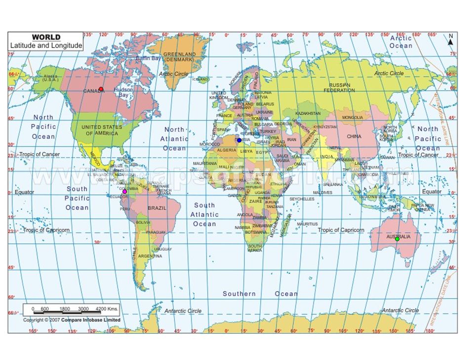
7
Practice with Latitude and Longitude On your printed map find the location of the following cities: – Yellowknife (62 N 114 W) – Melbourne (37 S 145 E) – Tripoli (32 N 13 E) – Guayaquil (2 S 80 W)
 – Melbourne (37 S 145 E) – Tripoli (32 N 13 E) – Guayaquil (2 S 80 W)")
9
The Globe The globe is one of the best ways to represent earth’s surface since both are spheres – Limits distortions seen in flat projections

10
Distortions on World Maps Take a look at Antarctica. Compare what you see in both maps. Now predict where what else would be distorted.

11
Ways to Minimize Distortions Since all flat maps have some degree of distortion, many different map “projections” have been invented to cut down on the distortion.

12
The Mercator Projection Oldest and most common Latitude lines close together at the equator and distances increasing at the poles Big distortion at the poles Commonly used by sailors for navigation

13
The Mercator Projection

14
The Robinson Projection Curved lines of longitude Displays the poles as lines instead of points Causes great distortion at the poles

15
The Robinson Projection

16
Conic and Gnomonic Projections – Good for small distances, but creates enormous distortions over large distances

17
Conic Projection

18
Gnomonic Projection

19
Summing Up Maps are used to represent the earth’s surface and its features Due to the difficulty in representing a spherical earth on a flat surface, numerous projections have been developed in mapping

Similar presentations


 W (Want to know) L (What I learned) Warm up- take out a piece of paper and do the “K” and the “W” for the above topic.>")


