Download presentation
Presentation is loading. Please wait.

1
The Water Cycle

2
The Longitudinal Profile

3
Processes of river erosion
Hydraulic action Abrasion Attrition Corrosion

4
How is material transported downstream?
Traction Saltation Suspension Solution

5
How is material transported downstream?

6
The Upper Course is the highest section which is found in the mountains or hills Here the river erodes a v-shaped valley, the path is fairly straight and it flows downhill steeply The landforms that are common in this course of the river are waterfalls and gorges

7
V-shaped valleys With time the river directs its energy into eroding the valley laterally. The whole process then repeats itself. The river uses its load to cut down into the bedrock causing vertical erosion. Loosened material is washed into the river increasing the load and therefore the ability to erode.

12
In its upper stage the river erodes vertically rather than laterally. Interlocking spurs are ridges produced when the young river twists and turns round obstacles of hard rock along its downward pathway. These ridges interlock with one another like the teeth of a zip fastener

13
Interlocking spurs (Lake District)
Slopes attacked by weathering V-shaped valley Eroded materials transported by river River erodes downwards (vertical erosion) Interlocking spurs Gravity and rainwater move material downwards (slope transport) River source
 Interlocking spurs. Gravity and rainwater move material downwards (slope transport) River source.")
14
The Upper Course

15
Rapids

16
Rapids on the Rhone

17
Waterfall formation

18
Waterfalls!

19
1. Waterfalls What part of the river course would you expect to find this feature? Identify 3 features of this waterfall? How does this feature move upstream?

20
The waterfall retreats back forming a gorge (steep sided valley)
Overhang becomes unsupported and falls into the plunge pool

21
1. Waterfalls

23
The geology of Gulfoss is a little more complex!
grey basalt sandstone mudstone tillite grey basalt conglomerate plunge pool Which of these different rocks do you think is the most resistant?

24
How do gorges develop?

25
The Middle Course the gradient that the river flows down is less steep, the river begins to meander and the valley sides are also less steep. Common landforms here are a wider river valley – slightly U shape, meanders

26
The Middle Course

28
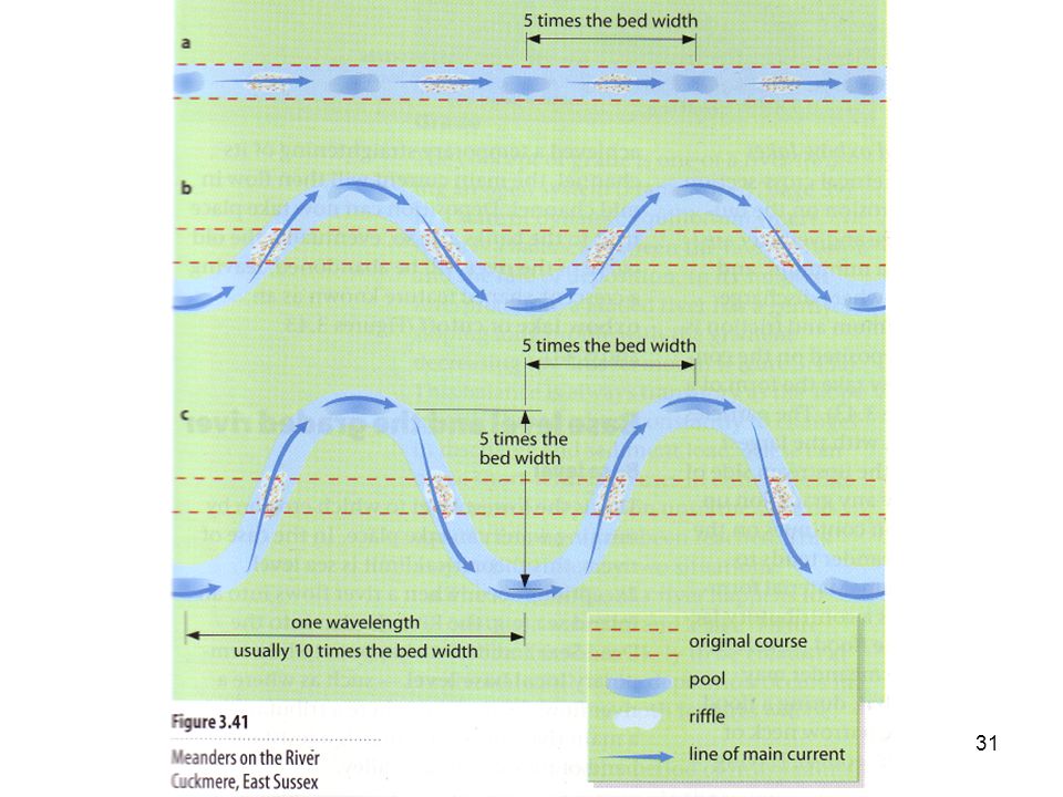
The genesis of a Meander
Pool… …are areas of deeper water where the flow of water is convergent. In a pool the erosion is greater due to reduced friction. Riffle… …An area of a river which is wide and shallow, with the water flowing over a pebble bed with protruding rocks. Friction is high due to the shallow depth and rough bed.

29
Helicoidal Flow

35
Meander = a bend in a river

36
Oxbow lakes

37
5. Oxbow Lakes/Meander Scars

38
4. Meanders Which bank of the meander does this photo show?
How does this bank develop? What problems could such a feature cause in an urban area? How do town planners solve this problem?

39
Floodplains

40
Floodplain formation Floodplains and levees are formed by deposition in times of river flood. The river’s load is composed of different sized particles. When a river floods it deposits the heaviest of these particles first. The larger particles, often pebble-sized, form the leveés. The sands, silts and clays are similarly sorted with the sands being deposited next, then the silts and finally the lightest clays. This deposition makes up the floodplain.

41
This is a cross section of a meander bend
This is a cross section of a meander bend. Sketch the diagram and mark on the following: river cliff fastest velocity slip off slope undercutting area of deposition

43
Landforms are primarily caused by:
processes of erosion processes of deposition a mixture of erosion and deposition Which of the following landforms are the result of a mixture of erosion and deposition? deltas meanders floodplains waterfalls leveés oxbow lakes rapids v-shaped valleys interlocking spurs

45
The Lower Course has the gentlest slopes - both in long profile and across the valley floor This almost flat land is known as the flood plain. The river may have very large meanders and ox-bow lakes. T The mouth of a river is when it reaches open water - either a lake or the sea. Under certain conditions a delta can be found here

46
Oxbow lakes new course of the river Meander neck becomes smaller
When the river floods it breaks through the thin meander neck and the river takes the easier, straight course. This leaves the meander loop ‘cut off’ as an oxbow lake. Over time, the oxbow lake will become colonised by vegetation. new course of the river Meander neck becomes smaller oxbow lake

47
Types of Flow Laminar Flow - at low velocities the fluid particles follow the streamlines Turbulent Flow - at higher velocities the flow breaks up into a fluctuating velocity pattern or eddies

48
Types of Rivers Perennial Rivers – flow all year round
Permanent Rivers Exotic Rivers Non Perennial Rivers – flow in rainy season Periodic Rivers Episodic Rivers

49
Permanent Rivers Flow all year round

50
Exotic Rivers Flow all year round
Reflect the characteristics of source Not of the region they are flowing through Nile River flows all year yet it runs through a desert region – source is the Ethiopian Highlands Orange River also flows through driest areas of South Africa – source is the Drakensberg

51
Episodic Rivers Flow only after an episode of rain
After a thunderstorm a river may only flow for a few hours A river may flow for a few days or weeks after an extended episode of rain For much of the year, the Fish River is barely a stream, and in parts it dries up completely. When the short wet season arrives, however, torrential rains run off the rock-hard soils. In a few hours the river swells into a raging torrent

52
Periodic Rivers Only flow after a period of rain
Is a seasonal flow – winter, summer Rivers may flow for 3 to 6 months

53
The Flood Plain

54
The Flood Plain The Flood Plain is a flat region of a valley floor located on either side of a river channel A floodplain is built of sediments deposited by the river that flows through it and is covered by water during floods when the river overflows its banks. Floodplains tend to develop on the lower and less steep sections of rivers.

55
Meandering and Braided Streams
River channels in floodplains form two kinds of patterns: meandering and braided Meandering rivers consist of a single main channel that bends and loops Braided rivers have numerous distinct channels that repeatedly divide and then merge again downstream

56
Oxbow Lakes In meandering rivers, sediment is eroded on the outside of bends (undercut banks) and deposited on the inside of bends (slip off slope) Over time, this causes meander loops to migrate downstream If the movement of one meander loop overruns the next one downstream, then a meander cut-off is formed This causes the course of the channel to be shortened as the two meander loops join The abandoned meander loop is gradually isolated as sediment is deposited at each end by the water flow in the main channel. This process eventually leads to the creation of an ox-bow lake

57
The Amazon River

58
The Niagra Falls

59
The Victoria Falls

60
Deltas Delta (geologic formation), deposit of soil or silt formed wherever a swift stream or river empties into a lake, ocean, or slower river, so called because its triangular shape resembles the Greek letter (delta) The triangular shape and the great width at the base are due to blocking of the river mouth by silt, with resulting continual formation of distributaries at angles to the original course. Deltas are usually characterized by highly fertile soil
, deposit of soil or silt formed wherever a swift stream or river empties into a lake, ocean, or slower river, so called because its triangular shape resembles the Greek letter (delta) The triangular shape and the great width at the base are due to blocking of the river mouth by silt, with resulting continual formation of distributaries at angles to the original course. Deltas are usually characterized by highly fertile soil.")
61
Requirements for the formation of a Delta
Constant supply of silt and sand Shallow lake or sea Little or no tidal action, wave action or current action

62
Types of Deltas Arcuate delta – Nile river Cuspate delta – Elbe River
Bird’s Foot delta - Mississippi Estuarine delta -

63
Types of Deltas

64
Dendritic Pattern

65
Centripetal Pattern

66
Drainage Patterns

68
Radial Pattern

69
Trellis Pattern

70
Deranged Pattern

71
Rectangular Pattern

72
Stream Order Hierarchical ordering system based upon the degree of branching (A second-order stream is formed by the joinig of two first order-streams; the junction of two second-order streams forms a third order stream

75
The peak rainfall is the time of highest rainfall
The peak rainfall is the time of highest rainfall. The peak discharge (the time when the river reaches its highest flow) is later because it takes time for the water to find its way to the river (lag time) . The normal (base) flow of the river starts to rise (rising limb) when run-off, ground and soil water reaches the river. Rock type, vegetation, slope and situation (ie is this an urban river?) affect the steepness of this limb. The falling limb shows that water is still reaching the river but in decreasing amounts. The run-off/discharge of the river is measured in cumecs - this stands for cubic metres per second. Precipitation is measured in mm - this stands for millimetres.
 is later because it takes time for the water to find its way to the river (lag time) . The normal (base) flow of the river starts to rise (rising limb) when run-off, ground and soil water reaches the river. Rock type, vegetation, slope and situation (ie is this an urban river ) affect the steepness of this limb. The falling limb shows that water is still reaching the river but in decreasing amounts. The run-off/discharge of the river is measured in cumecs - this stands for cubic metres per second. Precipitation is measured in mm - this stands for millimetres.")
Similar presentations


 Landforms of erosion:>")


