Download presentation
Presentation is loading. Please wait.

1
POLITICAL AND PHYSICAL DIVISION
INDIA POLITICAL AND PHYSICAL DIVISION Prepared by: Ms Reshma Mhaskar Pawar Public School Kandivali By Savita

4
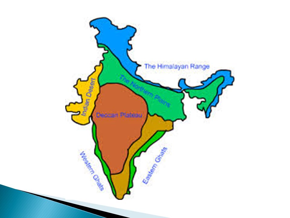
PHYSICAL DIVISION NORTHERN MOUNTAINS NORTHERN PLAINS THAR DESERT

5
LOCATION OF HIMALAYAS

6
THE NORTHERN MOUNTAINS
LOCATION – North of India HIGHEST PEAK- K2 (Godwin Austen) MEANING – Abode of snow IMPORTANCE- Climate, Rivers, important passes
 MEANING – Abode of snow. IMPORTANCE- Climate, Rivers, important passes.")
7
K2

8
K2 The “K” denotes the mountain range — Karakoram — and the “2” denotes that it is the second peak recorded. K2 has also been nicknamed “The Savage Mountain” because of the extreme level of danger it poses to climbers.

9
K2 Mt. K2 was named 'Mount Godwin-Austen' after Col. Henry Godwin-Austen (an Englishman), who was a surveyor, naturalist, topographer, and geologist. He was the first one to survey this mountain peak.
, who was a surveyor, naturalist, topographer, and geologist. He was the first one to survey this mountain peak.")
10
PHYSICAL DIVISION GREATER HIMALAYAS LESSER HIMALAYAS OUTER HIMALAYAS
PURVANCHAL RANGE

11
HIMALAYAS

12
CLASSIFICATION OF HIMALAYAS
GREATER HIMALAYAS: Highest range Mt Everest Average height 6000 Covered with snow Origin of rivers

13
GREATER HIMALAYAS

14
LESSER HIMALAYAS Middle Himalayas Height 4500m. Pir Panjal range
Important hill stations Nainital, Mussoorie

15
LESSER HIMALAYAS

16
OUTER HIMALAYAS Southern most range Also known as Shiwalik range Height 1500m Soft mud usually leads to landslides.

17
OUTER HIMALAYAS

18
PURVANCHAL RANGE Eastern boundary of India Garo , khasi, Jaintia hills

19
PURVANCHAL

20
IMPORTANCE OF HIMALAYAS
Natural boundary. Climatic barrier Perennial rivers. Important resource like timber

21
NORTHERN PLAINS

22
NORTHERN PLAINS

23
NORTHERN PLAINS PUNJAB PLAINS GANGA BASIN BRAHMAPUTRA VALLEY

24
IMPORTANCE FERTILE GOOD NETWORK OF RAIL AND ROAD TRANSPORT
CHEAP WATER TRANSPORT

25
THAR DESERT

26
THAR DESERT

27
THAR DESERT Area- Rajasthan, Gujrat , small area of Punjab
Rainfall- 20 – 25 cms Temperature- 52 C Climate- Dust storms Rivers- Few rivers

28
RIVERS

29
PENINSULA PLATEAU REGION

30
Formation of Deccan Plateau

31
PLATEAUS

33
CENTRAL HIGHLANDS DECCAN PLATEAU

34
CENTRAL HIGHLANDS IGNEOUS ROCKS SERIES OF RANGES LIKE MALWA PLATEAU
RIVERS LIKE SON, SINDH FLOW IN THIS AREA

36
DECCAN PLATEAU North- Vindya range East- Eastern Ghats
West – Western Ghats Formed due to lava flow Basalt rocks Cotton Known for minerals

37
RIVERS

38
WESTERN GHATS River Tapi to Kanyakumari Lie towards Arabian sea
Steep from the western coast All rivers originate from the western ghats

39
EASTERN GHATS Mahanadi valley to Nilgiri hills
Lie towards Bay of Bengal Rise gently from the east coast Only Mahanadi river originates from here

40
COASTAL PLAINS WESTERN COASTAL PLAINS EASTERN COASTAL PLAINS

41
COASTAL PLAINS

42
INDENTED COASTLINE

43
WESTERN COASTAL PLAINS
Lie between Western Ghats and Arabian sea Narrow and uneven Gets a lot of rain from south west monsoon winds Indented ports Konkan- Maharashtra Kanara- Karnataka Malabar- Kerela

44
EASTERN COASTAL PLAINS
Eastern Ghats and Bay of Bengal Alluvial soil due to deltas Silting makes it difficult for ports

45
EASTERN COASTAL PLAINS

46
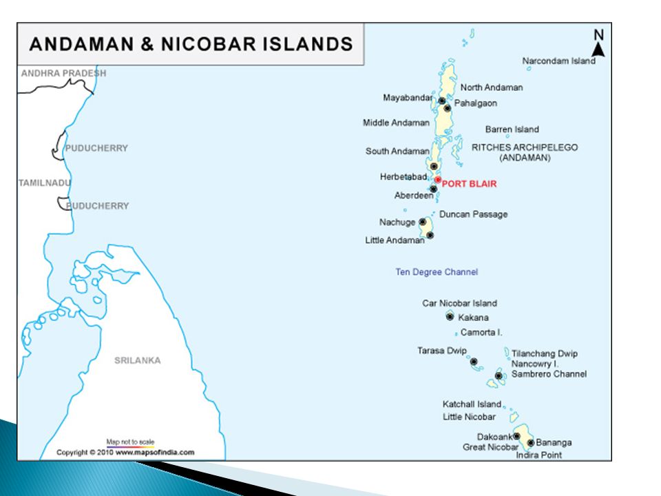
ISLANDS ANDAMAN AND NICOBAR REGION BAY OF BENGAL LAKSHADWEEP ISLANDS
ARABIAN SEA

47
ANDAMAN AND NICOBAR ISLAND

48
ANDAMAN AND NICOBAR ISLAND

49
ANDAMAN AND NICOBAR ISLAND

51
LAKSHADWEEP ISLANDS

52
LAKSHADWEEP ISLANDS

Similar presentations


 Write in agenda for the week>")
