Download presentation
Presentation is loading. Please wait.

1
13 Colonies Regions Compare & Contrast Chart
- Geography - NEW ENGLAND MIDDLE SOUTHERN Geography - Features that make the region unique - Farthest north. - Cooler Climate: - Shorter growing season. - Helped prevent disease. - Cold weather killed many. - Mostly hills & rocky soil. - Natural resources more important than agricultural crops. - Temperate climate: - Warm summers. - Cold winters. - landforms: - Coastal plain. - Piedmont (rolling hills). - Mountains. - Good Harbors. - Ideal for agriculture. - Warmest climate: - Helped colonists survive winter. - Warm, moist climate carried disease. - Broad coastal plain. - Hilly & forests. - Rich farmland, forests & fish.
. - Mountains. - Good Harbors. - Ideal for agriculture. - Warmest climate: - Helped colonists. survive winter. - Warm, moist climate. carried disease. - Broad coastal plain. - Hilly & forests. - Rich farmland, forests & fish.")
2
13 Colonies Regions Compare & Contrast Chart
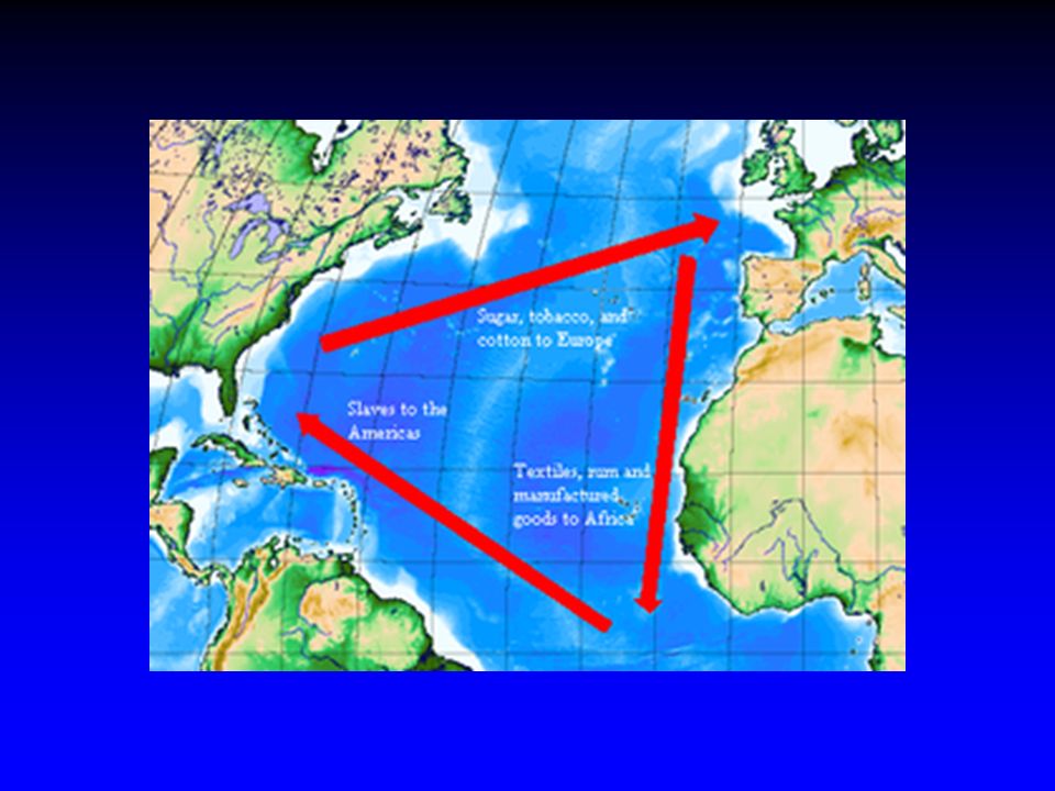
- Economy - NEW ENGLAND MIDDLE SOUTHERN Economy - Income Occupations Crops Grown Products - Depended on farming & commerce (trade). - Staple Crops: - Wheat. - Barley. - Rye. - “Breadbasket Colonies” - Urban centers like New York & Philadelphia. - Ports & Diversity. - Fur Trade. - Some slaves. - Hot & wet = agriculture. - Cash crops: - Tobacco. - Rice. - Indigo. - Forests: - Pitch. - Tar. - Turpentine. - Plantation system = slavery. - No major commercial cities. - Relied on the Atlantic Ocean: - Shipbuilding. - Trade. - Fishing. - Triangular Trade Routes: - Traded goods for rum, sugar cane, & molasses, then for slaves. - Key trade port: Boston, MA - Small farms.
. - Staple Crops: - Wheat. - Barley. - Rye. - Breadbasket. Colonies - Urban centers like. New York & Philadelphia. - Ports & Diversity. - Fur Trade. - Some slaves. - Hot & wet = agriculture. - Cash crops: - Tobacco. - Rice. - Indigo. - Forests: - Pitch. - Tar. - Turpentine. - Plantation. system = slavery. - No major. commercial cities. - Relied on the Atlantic. Ocean: - Shipbuilding. - Trade. - Fishing. - Triangular Trade. Routes: - Traded goods for. rum, sugar cane, & molasses, then. for slaves. - Key trade port: Boston, MA. - Small farms.")
3
13 Colonies Regions Compare & Contrast Chart
- Society - NEW ENGLAND MIDDLE SOUTHERN Society - Where from? Types of people (backgrounds) - Education - Social classes - Events - Founded on religion (Puritan faith). - “City Upon a Hill”. - John Winthrop. - Strong sense of faith, family, & community. - Very strict. - Massachusetts = 1st public education (1647). - First two colleges: - Harvard & Yale. - Diversity. - Religious tolerance. - Fast growth: - Westward expansion. - Philadelphia = largest colonial city. - Social order: 1.) Merchants (U). 2.) Craftsmen, Retail, businessmen (M). 3.) Sailors, unskilled workers, & some artisans (L). - Social order: 1.) Plantation owners. 2.) Poor farmers. 3.) Slaves. - Wealthy = gentry. Tutors or private schools. - Poor = home school.
 - Education. - Social classes. - Events. - Founded on religion. (Puritan faith). - City Upon a Hill . - John Winthrop. - Strong sense of faith, family, & community. - Very strict. - Massachusetts = 1st public education. (1647). - First two colleges: - Harvard & Yale. - Diversity. - Religious tolerance. - Fast growth: - Westward. expansion. - Philadelphia = largest colonial. city. - Social order: 1.) Merchants (U). 2.) Craftsmen, Retail, businessmen (M). 3.) Sailors, unskilled. workers, & some. artisans (L). - Social order: 1.) Plantation owners. 2.) Poor farmers. 3.) Slaves. - Wealthy = gentry. Tutors or private. schools. - Poor = home school.")
4
13 Colonies Regions Compare & Contrast Chart
- Politics - NEW ENGLAND MIDDLE SOUTHERN Politics Who was in charge? type of government? Important Documents? - Mayflower Compact: 1.) Plymouth. 2.) Elected legislature. 3.) Gov’t of the people. - Representative gov’t - Town meetings. - Ultimately – power in hands of the Church. - Fund. Orders of Connecticut: 1.) Gov’t power from “free consent of the people”. - Toleration - Indian treaties. - Eventually became royal colonies (governor controls). - House of Burgesses 1.) Jamestown (1619) 2.) 1st Representative body in colonies - Eventually became royal colonies (governor controls).
 Plymouth. 2.) Elected legislature. 3.) Gov’t of the people. - Representative gov’t. - Town meetings. - Ultimately – power in. hands of the Church. - Fund. Orders of. Connecticut: 1.) Gov’t power from. free consent of the. people . - Toleration. - Indian treaties. - Eventually became royal colonies (governor controls). - House of Burgesses. 1.) Jamestown (1619) 2.) 1st Representative. body in colonies. - Eventually became. royal colonies. (governor controls).")
5
13 Colonies Regions Compare & Contrast Chart
- Religion - NEW ENGLAND MIDDLE SOUTHERN Religion(s) Major religious groups Freedom of religion? - Puritan Church. - Church central to colonial life. - ALL settlers had to attend & support the Church. - Banishment for non-committed. - Great social & religious diversity. - Pennsylvania. - Founder: William Penn. - Quakers. - Religious Tolerance. - Presbyterians. - Lutherans. - Mennonites. - Jews = New York. - Colonies founded for economic rather than religious reasons. - Exception: - Maryland (Catholic). - Planters = Church of England (Anglican). - Poor settlers = Baptists & Methodists.
 Major religious. groups. Freedom of. religion - Puritan Church. - Church central to colonial life. - ALL settlers had to. attend & support the. Church. - Banishment for. non-committed. - Great social & religious diversity. - Pennsylvania. - Founder: William Penn. - Quakers. - Religious. Tolerance. - Presbyterians. - Lutherans. - Mennonites. - Jews = New York. - Colonies founded. for economic rather. than religious. reasons. - Exception: - Maryland. (Catholic). - Planters = Church of. England (Anglican). - Poor settlers = Baptists & Methodists.")
6
13 Colonies Compare/Contrast Chart
Key Colonies New England Massachusetts Rhode Island Middle New York Pennsylvania Southern Maryland Virginia Carolinas (N & S) Georgia
 Georgia.")
Similar presentations