Download presentation
Presentation is loading. Please wait.

1
BELL RINGER If Sid’s height is 80 centimeters plus half his own height, how tall is he? If Sid’s height is 80 centimeters plus half his own height, how tall is he?

2
YESTERDAY’S ANSWER Twelve thousand, twelve hundred twelve is Twelve thousand, twelve hundred twelve is 12,000 + 1200 + 12 = 13,212 12,000 + 1200 + 12 = 13,212

3
GEOGRAPHY (LATITUDE AND LONGITUDE) OBJECTIVES: Use absolute location to describe the location of North America Use absolute location to describe the location of North America Draw the Prime Meridian and Equator on a blank map Draw the Prime Meridian and Equator on a blank map
 OBJECTIVES: Use absolute location to describe the location of North America Use absolute location to describe the location of North America Draw the Prime Meridian and Equator on a blank map Draw the Prime Meridian and Equator on a blank map")
4
CLASSROOM RULES Comply with all federal, state and district policies Comply with all federal, state and district policies Do not do anything that creates unsafe or unhealthy conditions in my classroom Do not do anything that creates unsafe or unhealthy conditions in my classroom Do not do anything that interferes with your learning Do not do anything that interferes with your learning Do not do anything that interferes with anyone else’s learning Do not do anything that interferes with anyone else’s learning Do not let anyone else interfere with your learning Do not let anyone else interfere with your learning

5
CLASSROOM PROCEDURES Bring and use the proper materials at the proper time Bring and use the proper materials at the proper time No gum or food No gum or food Do not talk except when the activity permits or when you have a question (raise your hand first). Do not talk except when the activity permits or when you have a question (raise your hand first). Stay in your seat unless you have permission Stay in your seat unless you have permission Do not do work from other classes unless you have permission Do not do work from other classes unless you have permission Listen carefully to instructions, execute them to the best of your ability, and ask if you do not understand them Listen carefully to instructions, execute them to the best of your ability, and ask if you do not understand them Participate in the lesson by doing the correct activity at the correct time: listen, ask questions, discuss, read, write, research. Participate in the lesson by doing the correct activity at the correct time: listen, ask questions, discuss, read, write, research.
. Stay in your seat unless you have permission Stay in your seat unless you have permission Do not do work from other classes unless you have permission Do not do work from other classes unless you have permission Listen carefully to instructions, execute them to the best of your ability, and ask if you do not understand them Listen carefully to instructions, execute them to the best of your ability, and ask if you do not understand them Participate in the lesson by doing the correct activity at the correct time: listen, ask questions, discuss, read, write, research. Participate in the lesson by doing the correct activity at the correct time: listen, ask questions, discuss, read, write, research..")
6
VOCABULARY Terms we will be using today Absolute Location Equator Latitude Parallel (n) Prime Meridian Longitude Meridian Relative Location Hemisphere Arctic Circle Antarctic Circle Tropic of Cancer Tropic of Capricorn
 Prime Meridian Longitude Meridian Relative Location Hemisphere Arctic Circle Antarctic Circle Tropic of Cancer Tropic of Capricorn")
7
ABSOLUTE LOCATION Absolute location is a system of precisely describing location. It uses a grid system of x and y coordinates, similar to what you learned in Math Absolute location is a system of precisely describing location. It uses a grid system of x and y coordinates, similar to what you learned in Math We will be using Latitude and Longitude to locate places this year We will be using Latitude and Longitude to locate places this year Latitude is the Y-coordinate Latitude is the Y-coordinate Longitude is the X-coordinate Longitude is the X-coordinate Do not confuse “precisely” with “accurately” Do not confuse “precisely” with “accurately” “Precisely” means you can put your finger on it without having to think about it too much “Precisely” means you can put your finger on it without having to think about it too much Using whole degrees to describe location is not accurate Using whole degrees to describe location is not accurate

8
LATITUDE Latitude is the measurement of distance north or south of the Equator Latitude is the measurement of distance north or south of the Equator The Equator is the imaginary line of latitude halfway between the North Pole and the South Pole The Equator is the imaginary line of latitude halfway between the North Pole and the South Pole The North Pole is the northern end of the Earth’s axis of rotation The North Pole is the northern end of the Earth’s axis of rotation The South Pole is the southern end of the Earth’s axis of rotation The South Pole is the southern end of the Earth’s axis of rotation An “axis of rotation” is the line that a 3-dimensional object spins around An “axis of rotation” is the line that a 3-dimensional object spins around If you can spin a basketball on your fingertip, your fingertip is on one end of the ball’s axis of rotation If you can spin a basketball on your fingertip, your fingertip is on one end of the ball’s axis of rotation The Equator is the zero-point (0°) for Latitude – everything is measured from it The Equator is the zero-point (0°) for Latitude – everything is measured from it A line of Latitude is called a “Parallel” – note that it is a noun A line of Latitude is called a “Parallel” – note that it is a noun
 for Latitude – everything is measured from it The Equator is the zero-point (0°) for Latitude – everything is measured from it A line of Latitude is called a Parallel – note that it is a noun A line of Latitude is called a Parallel – note that it is a noun")
9
MEASURING LATITUDE Latitude is the easiest coordinate to measure in the Northern Hemisphere. It is roughly the angle between the North Star and the horizon Latitude is the easiest coordinate to measure in the Northern Hemisphere. It is roughly the angle between the North Star and the horizon There is no southern pole star, so measuring latitude is a bit trickier in the Southern Hemisphere, but it’s not horribly difficult There is no southern pole star, so measuring latitude is a bit trickier in the Southern Hemisphere, but it’s not horribly difficult

10
MEASURING LATITUDE Because Latitude measures distance between the North Pole and the South Pole and the Equator (0°) is halfway between, a measure of latitude will never be more than 90° Because Latitude measures distance between the North Pole and the South Pole and the Equator (0°) is halfway between, a measure of latitude will never be more than 90° South Pole (90°S) Equator (0°) North Pole (90°N) North Latitude (x°N) South Latitude (x°S) Equator (0°)
 is halfway between, a measure of latitude will never be more than 90° Because Latitude measures distance between the North Pole and the South Pole and the Equator (0°) is halfway between, a measure of latitude will never be more than 90° South Pole (90°S) Equator (0°) North Pole (90°N) North Latitude (x°N) South Latitude (x°S) Equator (0°)")
11
YOU DO Fold your group’s book cover in half (it should already be folded since we did that on Thursday before putting it away). Fold your group’s book cover in half (it should already be folded since we did that on Thursday before putting it away). If you need another book cover, let me know. If you need another book cover, let me know. On the left half, at either the top or the bottom, write “Latitude” in big letters. On the left half, at either the top or the bottom, write “Latitude” in big letters. You are going to copy the drawing on the next slide onto the left side of your book cover. You are going to copy the drawing on the next slide onto the left side of your book cover.
. If you need another book cover, let me know. If you need another book cover, let me know. On the left half, at either the top or the bottom, write Latitude in big letters. On the left half, at either the top or the bottom, write Latitude in big letters. You are going to copy the drawing on the next slide onto the left side of your book cover. You are going to copy the drawing on the next slide onto the left side of your book cover..")
12
LATITUDE LINES (PARALLELS)
")
13
LONGITUDE Longitude is the measure of distance east or west of the Prime Meridian, and is the x-coordinate of our grid system Longitude is the measure of distance east or west of the Prime Meridian, and is the x-coordinate of our grid system The Royal Observatory in Greenwich (pronounced GREN-ich), England (it’s near London) is designated as 0° The Royal Observatory in Greenwich (pronounced GREN-ich), England (it’s near London) is designated as 0° The location of the Prime Meridian is the result of a treaty, not some natural feature, like the North Star. In other words, it is where it is because everyone agreed to do it that way. The location of the Prime Meridian is the result of a treaty, not some natural feature, like the North Star. In other words, it is where it is because everyone agreed to do it that way. Longitude describes a circle, so there are 360 degrees Longitude describes a circle, so there are 360 degrees If you are east of Greenwich, you use East Longitude (x°E) If you are east of Greenwich, you use East Longitude (x°E) If you are west of Greenwich, you use West Longitude (x°W) If you are west of Greenwich, you use West Longitude (x°W) If you are halfway around the circle, you are on the International Date Line (180°) If you are halfway around the circle, you are on the International Date Line (180°)
 If you are east of Greenwich, you use East Longitude (x°E) If you are west of Greenwich, you use West Longitude (x°W) If you are west of Greenwich, you use West Longitude (x°W) If you are halfway around the circle, you are on the International Date Line (180°) If you are halfway around the circle, you are on the International Date Line (180°).")
14
YOU DO On the right half of your book cover, at either the top or the bottom, write “Longitude” in big letters. On the right half of your book cover, at either the top or the bottom, write “Longitude” in big letters. You are going to copy the drawing on the next slide onto the right side of your book cover. You are going to copy the drawing on the next slide onto the right side of your book cover.

15
LONGITUDE LINES (MERIDIANS)
")
16
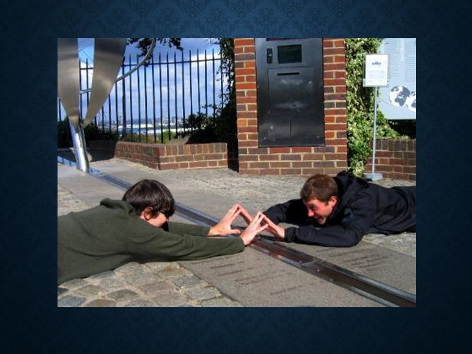
LOCATION OF GREENWICH

18
PUTTING IT TOGETHER Equator Prime Meridian Lines of Latitude (Parallels) Lines of Longitude (Meridians) 40°S 20°S 80°N 60°N 40°N 20°N 60°S 80°S 70°W 100°W 40°E 70°E100°E
 Lines of Longitude (Meridians) 40°S 20°S 80°N 60°N 40°N 20°N 60°S 80°S 70°W 100°W 40°E 70°E100°E")
19
HEMISPHERES Each of our zero points divides the earth into two pieces Each of our zero points divides the earth into two pieces Those pieces are called “hemispheres” Those pieces are called “hemispheres” The equator divides the earth into a northern hemisphere and a southern hemisphere The equator divides the earth into a northern hemisphere and a southern hemisphere North of the equator = northern hemisphere North of the equator = northern hemisphere South of the equator = southern hemisphere South of the equator = southern hemisphere The Prime Meridian and International Date Line divide the earth into an eastern hemisphere and a western hemisphere The Prime Meridian and International Date Line divide the earth into an eastern hemisphere and a western hemisphere East of the Prime Meridian = eastern hemisphere East of the Prime Meridian = eastern hemisphere West of the Prime Meridian = western hemisphere West of the Prime Meridian = western hemisphere

20
WHAT WE SAY VS. WHAT WE MEAN We say that Europe and Africa are in the Eastern Hemisphere, but We say that Europe and Africa are in the Eastern Hemisphere, but All of Spain, Portugal, Ireland and Iceland, most of the UK and a piece of France are west of the Prime Meridian All of Spain, Portugal, Ireland and Iceland, most of the UK and a piece of France are west of the Prime Meridian About 1/6 th of Africa is west of the Prime Meridian About 1/6 th of Africa is west of the Prime Meridian We mean that the Americas are “Western Hemisphere” or “New World” and that everyone else is “not New World” or “not Western Hemisphere” We mean that the Americas are “Western Hemisphere” or “New World” and that everyone else is “not New World” or “not Western Hemisphere”

21
LET’S DO SOME LOCATING Most world maps showing North America on the left are centered on the Prime Meridian (fold the map in half to find it) Most world maps showing North America on the left are centered on the Prime Meridian (fold the map in half to find it) The Equator is close to the N-S dip on the NE coast of South America (this is approximately where the Amazon River empties into the Atlantic Ocean) The Equator is close to the N-S dip on the NE coast of South America (this is approximately where the Amazon River empties into the Atlantic Ocean)
 Most world maps showing North America on the left are centered on the Prime Meridian (fold the map in half to find it) The Equator is close to the N-S dip on the NE coast of South America (this is approximately where the Amazon River empties into the Atlantic Ocean) The Equator is close to the N-S dip on the NE coast of South America (this is approximately where the Amazon River empties into the Atlantic Ocean)")
22
EASTERN AND WESTERN HEMISPHERES Eastern HemisphereWestern Hemisphere

23
NORTHERN AND SOUTHERN HEMISPHERES Southern Hemisphere Northern Hemisphere

24
AND TOGETHER… Eastern Hemisphere Southern Hemisphere

25
ACTIVITY Put your name, ID number, the date and your period on your map Put your name, ID number, the date and your period on your map Using a straight-edge (ruler or folded sheet of paper), draw and label: Using a straight-edge (ruler or folded sheet of paper), draw and label: The Equator The Prime Meridian Label North America South America Europe Asia Africa Australia
, draw and label: Using a straight-edge (ruler or folded sheet of paper), draw and label: The Equator The Prime Meridian Label North America South America Europe Asia Africa Australia")
27
TOMORROW We will learn how to use Latitude and Longitude to locate things on the Earth’s surface. We will learn how to use Latitude and Longitude to locate things on the Earth’s surface.

Similar presentations


>")


