Download presentation
Presentation is loading. Please wait.

1
Geography of the Czech Republic

2
The Czech landscape is quite varied
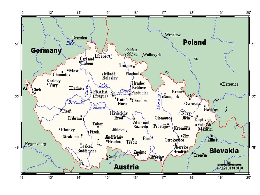
The Czech landscape is quite varied. Bohemia, to the west, consists of a river basin, drained by the Elbe (Czech: Labe) and Vltava rivers. It is surrounded by mostly low mountains such as the Sudetes with its part Krkonoše, containing the highest point in the country, the Sněžka at 1,602 metres (5,256 ft). Moravia, the eastern part, is also quite hilly and is drained predominantly by the Morava river, but also contains the source of the Oder (Czech: Odra) river. Water from the landlocked Czech Republic flows to three different seas: the North Sea, Baltic Sea and Black Sea.
 and Vltava rivers. It is surrounded by mostly low mountains such as the Sudetes with its part Krkonoše, containing the highest point in the country, the Sněžka at 1,602 metres (5,256 ft). Moravia, the eastern part, is also quite hilly and is drained predominantly by the Morava river, but also contains the source of the Oder (Czech: Odra) river. Water from the landlocked Czech Republic flows to three different seas: the North Sea, Baltic Sea and Black Sea.")
3
The Czech Republic also possesses Moldauhafen, a 30,000-square-metre (7.4-acre) enclave in the middle of Hamburg docks, which was awarded to Czechoslovakia by Article 363 of the Treaty of Versailles to allow the landlocked country a place where goods transported downriver could be transferred to seagoing ships; this territory reverts to Germany in 2028.
 enclave in the middle of Hamburg docks, which was awarded to Czechoslovakia by Article 363 of the Treaty of Versailles to allow the landlocked country a place where goods transported downriver could be transferred to seagoing ships; this territory reverts to Germany in 2028.")
5
Location: Central Europe, southeast of Germany
Satellite image of the Czech Republic Geographic coordinates: 49°45′N 15°30′E Map references: Europe Area: total: 78,866 km2 (30,450 sq mi) land: 77,276 km2 (29,836 sq mi) water: 1,590 km2 (610 sq mi) Area - comparative: slightly smaller than South Carolina; slightly larger than Scotland Land boundaries: total: 1,881 km (1,169 mi) border countries: Austria 362 km (225 mi), Germany 815 km (506 mi),[1] Poland 658 km, Slovakia 215 km (134 mi)
 land: 77,276 km2 (29,836 sq mi) water: 1,590 km2 (610 sq mi) Area - comparative: slightly smaller than South Carolina; slightly larger than Scotland. Land boundaries: total: 1,881 km (1,169 mi) border countries: Austria 362 km (225 mi), Germany 815 km (506 mi),[1] Poland 658 km, Slovakia 215 km (134 mi)")
6
Coastline: 0 km (landlocked) Maritime claims: none (landlocked)
Climate: temperate; hot summers; cold, cloudy, white winters Terrain: Bohemia in the west consists of rolling plains, hills, and plateaus surrounded by low mountains; Moravia in the east consists of very hilly country

7
lowest point: Elbe River - 115 m (377 ft)
Elevation extremes: lowest point: Elbe River m (377 ft) highest point: Sněžka - 1,602 m (5,256 ft) Natural resources: hard coal, soft coal, kaolin, clay, graphite, timber, uranium Land use: arable land: 41% permanent crops: 2% permanent pastures: 11% forests and woodland: 34% other: 12% (1993 est.) Irrigated land: 240 km2 or 93 sq mi0 (1993 est.) Natural hazards: flooding
 highest point: Sněžka - 1,602 m (5,256 ft) Natural resources: hard coal, soft coal, kaolin, clay, graphite, timber, uranium. Land use: arable land: 41% permanent crops: 2% permanent pastures: 11% forests and woodland: 34% other: 12% (1993 est.) Irrigated land: 240 km2 or 93 sq mi0 (1993 est.) Natural hazards: flooding.")
8
Sněžka

Similar presentations


 (three bullet points)>")


![449927853 The traditional view (mostly influenced by Russian and Polish historiography) [17] on the etymology of Ukraine is that.](/21/6282538/big_thumb.jpg "449927853 The traditional view (mostly influenced by Russian and Polish historiography) [17] on the etymology of Ukraine is that.>")
