Download presentation
Presentation is loading. Please wait.

2
Geography of Mesopotamia What does Mesopotamia mean? The Land Between the Two (2) Rivers Tigris River 11.11. Euphrates River 22.22. What are the names of these two rivers?
 Rivers Tigris River Euphrates River What are the names of these two rivers .")
3
What is another name for the Area Around Mesopotamia? The Fertile Crescent Why would we call it that? Because it is shaped like a quarter moon and the land is able to be farmed over and over. (Green Area)
.")
4
What is a Plateau? An area of elevated flat land.

5
Flood Plain 2. The Two Rivers form and run over the Elevated Flat Land 3. The Rivers flow and flood the low land making the land fertile for planting crops Persian Gulf 4. The Two Rivers Empty into the Persian Gulf 4. The Two Rivers Empty into the Persian Gulf The paths of the Tigris and Euphrates Rivers. This creates Mesopotamia and rich farming land. Can you name the current country Mesopotamia is located in? Plateau Taurus Mountains (In Present Day Turkey) 1. Water from the melting snow rushes to the valley below.
 1. Water from the melting snow rushes to the valley below..")
6
IRAQ

7
Silt Silt flows down Tigris & Euphrates Deposits mostly down near Persian Gulf (Southern Mesopotamia) Droughts Not much Rain Flood at Harvest Time not at Growing Time Irrigation Create Canals and Artificial Lakes Controlled Water for use when needed
 Droughts Not much Rain Flood at Harvest Time not at Growing Time Irrigation Create Canals and Artificial Lakes Controlled Water for use when needed")
9
March 16, 2005 February 7, 2005 Satellite Image of the Tigris River Before & After Flooding Iraq, 2005 Tigris River

11
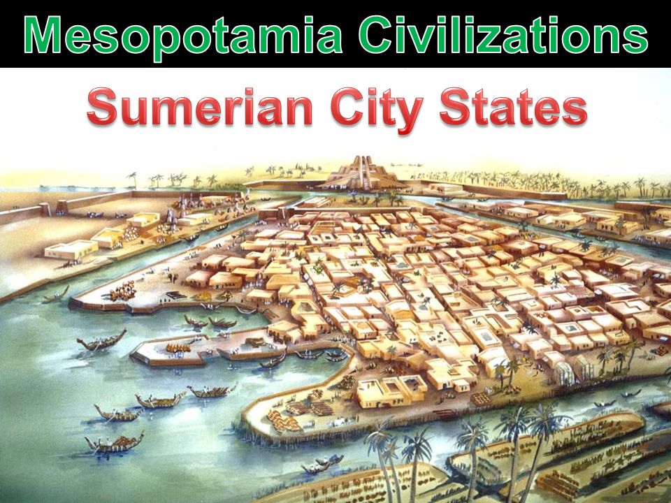
Sumer What is a city-state? A self-governing city which also governs surrounding villages. Erid u Most important city- states were: Ur, Uruk, Eridu

12
Sumer City-States c. 3000 BC Same time as Menes unified Egypt Sometimes fought for control of neighboring city-states

13
Architecture (building) - Ziggurat Located in center of cities, large, towering mud-brick building. Had a temple at the top, for religious purposes.

15
Writing Cuneiform – System of writing invented in Sumer. Used for record keeping, laws, stories, instructions, riddles, proverbs, education, math, and science. Scribes – Mostly Boys, but some girls (rare)
.")
16
Pictur e

17
City Life Huge city gates, with large walls. Often went to war with other city-states, for resources such as river water. Food brought to cities by area farmers

18
Religion City revolved around temple & religion. Food brought to feed temple god and priests and King. Each city-state worshiped a different god or goddess. Polytheism (many gods) (Ishtar – Love & War or Enki – Water)
 (Ishtar – Love & War or Enki – Water).")
19
Sargon Founder of the World’s 1st Empire (Akkadian Empire) Worked his way up as servant of King of Kish, and then took over as King. Expanded Empire North (Syria) and West to Mediterranean Coast (Phoenicians)
 and West to Mediterranean Coast (Phoenicians).")
20
Sargon 2334 BC - 2279 BC He traded with all areas of his empire. Mesopotamian farm goods traded for timber & wine. Cuneiform writing became the language of the empire.

Similar presentations


, Assyrians and Phoenicians and their contributions to civilization.>")


